
 An oxbow lake is a body of water that forms when a meander in a river is cut off from the main river channel. This is a natural process of the way meanders form. In areas of low slope, flood plains and such, the path of the river begins to wander back and forth creating meanders, curves.
Along each curve, the flow of the river is constantly eroding the outside bank of the meander, while at the same time depositing material on the inside. This is because the area of fastest flow in the river is forced to the outside bank on the curves and the slowest flow is on the inside. 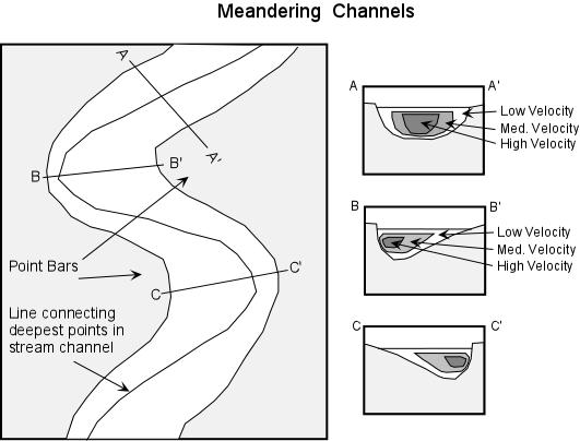 Faster water carries more sediment causing the erosion. The slower water is unable to carry as much sediment, so some sediment drops out of the water.
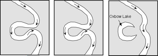
Over time, this erosion on the outer bank of each turn in the river exaggerates each turn until the meanders turn back on themselves and meet. The river then changes course slightly and takes the shorter route through the connected meander, leaving the other branch of the meander as an oxbow lake.
Another way for a meander to be abandoned is through a flood. The high flow during a flood bypass the long winding pathways for a more direct route before the meanders have a chance to connect.
When the LA River flowed freely, it meandered through this area. This park is an example of what the river may have looked like as it passed through the LA Basin. This small meander was later abandoned for some other path. Now LA River has been channelized and forms a straight path to the harbor.
 All images from Prof. Stephen A. Nelson, Tulane University. Click images for a larger version.
An animation of river meander formation can be found at http://www.cleo.net.uk/resources/displayframe.php?src=309/consultants_resources%2F_files%2Fmeander4.swf
Logging requirements:
Send me a note with :
- The text "GC1199N Oxbow Lake on the LA River" on the first line
- The number of people in your group.
- Identify the areas along the lake that would have been where the most erosion would have occurred and were deposition would have occurred.
- From what you can tell, using the occurance of plants, which area of the lake is the deepest and does that agree with the diagrams of the meander provided.
The above information was compiled from the following sources:
- Wikipedia, Oxbow lake,
- http://en.wikipedia.org/wiki/Oxbow_lake Prof. Stephen A. Nelson, Tulane University, Streams and Drainage Systems, http://www.tulane.edu/~sanelson/geol111/streams.htm, This page last updated on 15-Oct-2003
- Brown, Arthur R. and John Cooper, A Day on the Palos Verdes Peninsula, Pacific Section SEPM Field Trip to Commemorate the 60th Anniversary of the Publicaion of Geology and Paleontology of the Palos Verdes Hills, California, By Woodring, Bramlette, and Dew, USGS Professional Paper 207, Pacific Section SEPM, Book 102, October 7, 2006.
- Another piece of interesting information for this particular oxbow lake can be found at the following link:
http://lapropo.org/sitefiles/Machado/machadointro.htm