Caballo Overlook on Brushy Mountain Traditional Geocache
Caballo Overlook on Brushy Mountain
-
Difficulty:
-

-
Terrain:
-

Size:  (regular)
Please note Use of geocaching.com services is subject to the terms and conditions
in our disclaimer.
|
The cache is hidden on Brushy Mountain at the end of a rough
jeep road. It is about a mile past the Travelers Crossroads cache
(GC116JE) along the same road. See GC116JE for more information on
the area. Also, the roads and both caches are visible on Google
Earth - it's worth some planning so you don't take the wrong road
fork.
The terrain is rated a 3.5 due to the length of the hike
(assuming that many of you will have to hike to get to this cache)
and the rough, rocky area where the cache is hidden. It was very
roughly a 10 mile round trip hike for me, although I could have
driven further and cut the hiking distance.
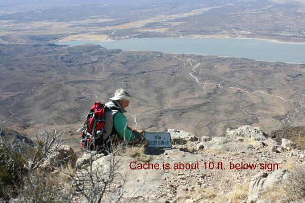
The cache is now an ammo can. It's hidden in a hole under the
base of the 10 foot drop-off at the end of the road (see photo
below). It's probably easiest to find the zero on top (use the
picture), then go back up the road until you find an easy way down
to the lower level. You do NOT need to climb down the 10 foot
drop-off.
To get to the cache area
Some of the roads are not well marked, and the road numbers seem to
vary depending on what maps you use, but here goes: from the south,
take the Upham exit off of I25, then take CR E072 then CR E070
which turns into CR A013. From the north, take NM 51 to Engle and
then go south on CR A013. From CR A013 go west on CR A039 (becomes
A012) to A008 to A010 to A003 (see waypoints below). These roads
were passable by reasonable clearance 2wd vehicles until I got to
Timber Mountain. The road up Timber Mountain (CR A003) was steep
and a little rougher, but still a pretty good road. 2wd vehicles
should decide for themselves how far in to drive. High clearance
4x4's should be able to get to the road fork at the high ridge to
Brushy Mountain (at the old water tank). From there on the road is
pretty rough. Those with short wheel base high clearance vehicles
(Jeeps and ATV's) may be able to drive to the cache - you decide.
If you're in good shape and want a longer hike or mountain bike
ride, park at the bottom of the mountain and go from there (rough
guess is about 10 miles). See GC116JE for Cespilot's route
description. Note that there are lots of roads in the area and
perhaps a better route is available, but I have no idea of the road
conditions.
|
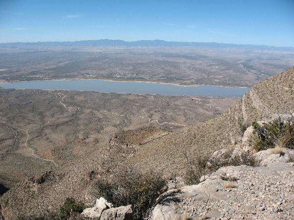
View of Caballo Lake from cache
location on Brushy Mountain
Cache is hidden about 10 feet below the
sign
Additional Hints
(Decrypt)
[See photo below and take the picture with you!]