Waupaca's Bandstand on the Yellowstone Trail 2.0 Mystery Cache
Waupaca's Bandstand on the Yellowstone Trail 2.0
-
Difficulty:
-

-
Terrain:
-
Size:  (small)
Please note Use of geocaching.com services is subject to the terms and conditions
in our disclaimer.
The historic Yellowstone Trail went through Waupaca, and this cache will first take you to 3 of the historic buildings along the route of the Yellowstone Trail, and then to nearby Brainerd Bridge Park just 1 mile NW of downtown to find the final cache alongside the river.
At the coordinates listed above, you will be parked near the Dane's Antique Store, which during the days of the Yellowstone Trail was the Danes Opera House.
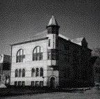 The Dane’s Home Society was organized in 1877 for social and literary purposes. The great brick building you see at this location was constructed in 1884. The Society provided a Danish language library, insurance, and other help to its Danish membership and its doors were open to the community for social gatherings. The building was referred to as the Dane’s Opera House after the city’s opera house burned in 1904. It was also used for drilling the National Guard, school graduations, and public lectures. The Society disbanded in the 1940’s, and the building is now an antique store. It is private property, and you do not need to go inside, unless you are interested in antiques.
The next location to visit is the bandstand, which has been used as the City of Waupaca’s trademark.
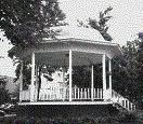 It was built in 1898 to accommodate the city’s two bands and provide a place for civic and social gatherings. It is one of the oldest bandstands in the state. President-to-be Ronald Regan spoke to a national audience in 1980 from this location.
The bandstand is at 44.21.436; 89.05.088.
The third location to visit is the Yellowstone Garage, now called Hanson’s Auto Exchange.
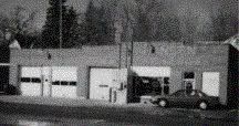
This building was constructed in approximately 1909. C. E. Johnson rented it as a garage in 1913. In 1915 he purchased the building and made extensive improvements. In February 1917 Dayton Baldwin leased the garage, and named it the “The Yellowstone Garage,” from Johnson, who remained on as a mechanic. An office was added for use in selling Oldsmobile and Oakland automobiles. You might notice the old Oldsmobile sign still present at this location.
The Yellowstone Garage still has an old Shell gas pump out in front, with gas a fraction of today’s prices. (PLEASE NOTE: AS OF 3/22/16 THE PUMP IS GONE, BUT THE PRICE WAS 49CENTS WHEN THE PUMP WAS STILL THERE. THE GARAGE IS STILL STANDING FOR THOSE WHO CARE TO TAKE A GANDER.)
The garage is at 44.21.587; 89.05.143
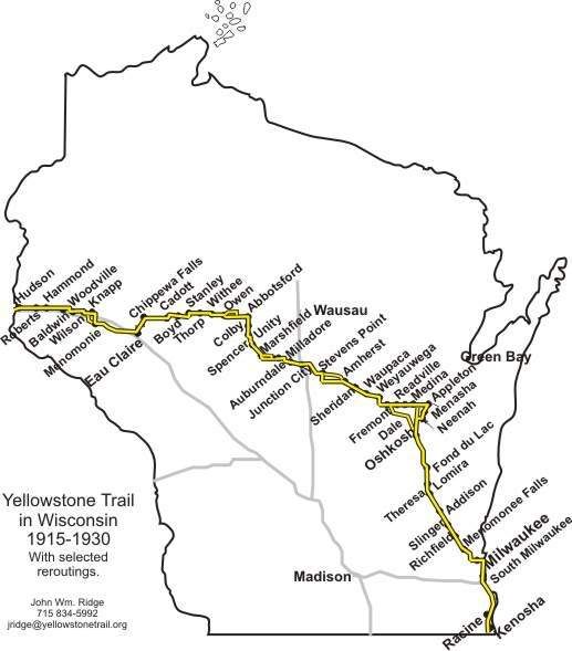
This is one of several caches I have placed along the route of the historic Yellowstone Trail. The trail is a historic motor route that went across Wisconsin from 1918 to 1930. The Wisconsin portion of the Yellowstone Trail is 406 miles long, starting at the state line south of Kenosha and going north, and then west to Hudson. The Wisconsin segment is just a part of one of America’s first transcontinental auto routes, a 3,754-mile long road that started in Plymouth Rock, Massachusetts and went to Puget Sound, Washington.
Before there were numbered highways in the United States there were names attached to roads to help motorists navigate from town to town or from county to county. Hailed as being “A Good Road from Plymouth Rock to Puget Sound,” the Yellowstone Trail began as a 25-mile stretch of road near Ipswitch, South Dakota.
In October 1912, Mr. J. W. Parmley formed the Yellowstone Trail Association. By 1917 the Yellowstone Trail had grown to become the main auto route for those travelling from the East Coast to Yellowstone National Park and the Pacific Northwest. While the Association did not build roads, it did lobby local governments in towns along the Trail to help promote the fledgling automobile tourism industry by building and maintaining “good roads.” Trail towns paid the Association a small fee or “assessment” to help cover advertising expenses and upkeep of the Trail.
More information on the Yellowstone Trail, including maps can be found at http://www.yellowstonetrail.org/id18.htm
The Yellowstone Trail entered the city of Waupaca by what was the Bunker Hill School located on the south side of current Highway 10 at County Road A (on Appletree Lane). It followed Appletree Lane north through the original Barnes Apple Orchard and into what is now Churchill Street. From Churchill Street the Yellowstone Trail turned west onto School Street (which becomes Badger Street) to the downtown area. A north turn at Badger Street the traveler went up Main Street, turning north at the Dane’s Home onto Granite Street. It continued west onto Hillcrest where it merges into Fulton Street, leaving town westward past “Chady’s Corner” (State Hwy. 54 and County Hwy. QQ).
There are many historic buildings in Waupaca along the route of the Yellowstone Trail. For this cache, I am listing just 3 of them, but a complete list can be found at: http://www.mainstreet-marketplace.com/pages/web_Pages/new_page_7.htm
The trail almost did not go through Waupaca. During planning meetings in Marshfield, cities such as Grand Rapids, Shawano and Wausau tried to divert the route through their areas citing the bad condition of roads in the Waupaca/Weyauwega area.
Under the guidance of Erle Whipple, of Waupaca, it was determined to leave the route as initially proposed. Here is an interesting quote from the 1915 Waupacan Republican: "Tuesday, May 25, was the date for the meeting of delegates all along that section of the proposed Yellowstone Trail lying in Wisconsin and there was a large attendance at Marshfield to complete plans for securing the necessary concerted action on the part of those living along the proposed route to secure the necessary work on this route to warrant the promoters in pledging that this highway will be constructed and maintained in suitable condition to be used as an ocean to ocean route for automobiles. The road from Stevens Point to Fremont through Amherst, Sheridan, Waupaca and Weyauwega has been shunned by auto drivers for the past year or more and a large delegation from Grand Rapids was present at Marshfield in the hope that the road might be diverted away from Stevens Point and go through Grand Rapids instead. Mr. Erle Whipple of this city very naturally joined with the delegation from Stevens Point in an effort to hold the route through these points as was originally planned. Wausau and Shawano also made an attempt to divert the route north of the route outlined and it is necessary for the people living along this section of the Trail to get busy and keep a good thing when it is offered."
Whipple was active in setting up “Trail Days” to improve the roads. He was also the sub-relay manager in September, 1917, when the War Department and Yellowstone Trail Association set up a relay to send an official War Department message from coast to coast in 5 days. An average of 30 miles an hour was required to meet this challenge and the sub-manager not only arranged for cars capable of traveling these speeds required to meet the deadline, but arranged for drivers not to be arrested by police while driving through their areas at such reckless speeds.
The final cache is at:
44.21.9BC
89.06.DE4
B = The number of sides on the bandstand - 1.
C = The number of Yellowstone Trail signs within sight of the bandstand.
D = The third digit of the street address of the Dane House.
E = The number of sides of the tower on the SE corner of the Dane House - 2
Additional Hints
(Decrypt)
Gurer hfr gb or na nzzbpna va gur oebxra gerr urer. Ubjrire vg jnf fgbyra, naq ercynprq jvgu n cersbez unatvat 5 srrg uvtu