As this is an EarthCache there are special
logging requirements and NO container to find. Logs not meeting the
posted requirements below may be deleted.
The listed coordinates N44 25.461 W87 56.443 are for the parking
area. Park hours are 8am to dark. No pets are allowed and great
care should be taken if children are brought to the site. Do not
leave the established trail as the cliffs are potentially
unstable.
Fonferek Glen is part of the
Brown County Park System. Here you will see a beautiful waterfall.
While the best time to see the waterfall in action is after a
strong rain, a visit any time of the year will be rewarded with
great views, in fact visiting in winter you will likely get to see
the falls as a large column of frozen water. You should expect to
walk about a quarter of a mile round trip on mostly level
ground.
* Welcome to the brink: Fonferek
Falls *
Formation:
A waterfall can be formed in many ways; here the water flows over a
sudden break in elevation. At Fonferek Falls this break in
elevation is provided by the Niagara Escarpment.*
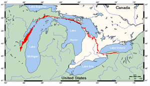
*The Niagara Escarpment
|
| The Niagara Escarpment shown above in red is the edge of a
thick series of dolomite (sedimentary stone) layers formed during
the Silurian age. The rock is very resistant to erosion and stands
up in relief as a prominent line of bluffs. This steep bluff owes
its prominence to both the resistance of the Silurian dolomite
layers and the relative softness of the Ordovician and Devonian era
rocks on either side. |
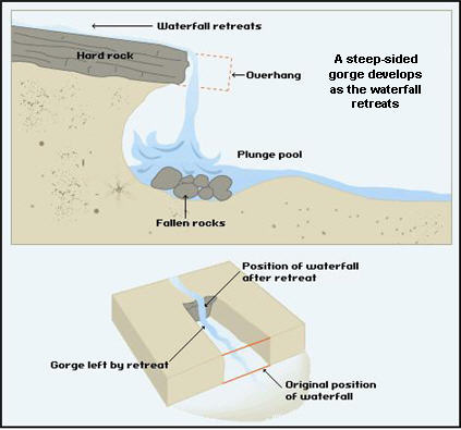
Waterfall Features:
Looking at the picture below one can see many features typical of a
waterfall. Depicted is an example much like the falls you are
viewing at Fonferek Glen. As you can see the upper layer of rock is
more resistant to erosion than the lower layers. When this is the
case you will see undercutting due to splashback. This will form a
shallow cave-like formation behind the waterfall and a plunge pool
under the waterfall. Eventually, the overhangs more resistant cap
rock will collapse into the pool below. These fallen rocks are then
broken down by attrition as they collide with each other. The rocks
also erode the base of the waterfall by abrasion, creating an even
deeper plunge pool.
This constant action of undercutting and collapse
results in a steady retreat upstream creating a gorge of recession.
A part of this same escarpment, Niagara Falls used to recede about
3.8 feet each year before water diversion and anti-erosion efforts
were put into place beginning in 1906. Here as the water supply is
far smaller the rate of recession is only a fraction of that at
less than an inch per year.
Please be sure to obey all signs and stay behind
the protective fencing.
|
Logging Requirements:
***DO NOT GO
BEYOND THE TRAIL FOR ANY REASON***
The photo and questions are to be taken/answered from the
trail.
You must
E-mail me the answer to the following two questions:
(do not answer these questions in your log)
Question
one: ESTIMATE the height of the falls.
Question two: On sign #10 in the parking lot, email me the second
line of text on the sign.
Uploading
pictures of the waterfall is the best way to thank the cache
developer and to provide a year round glimpse of this
feature.
|
Permission for this cache has been granted by
Douglas R. Hartman, Brown County Facility and Park
Management.
References:
http://www.uwsp.edu/geo/projects/geoweb/participants/dutch/geolwisc/geostops/fonferek.htm
http://www.gowaterfalling.com/waterfalls/wequiock.shtml