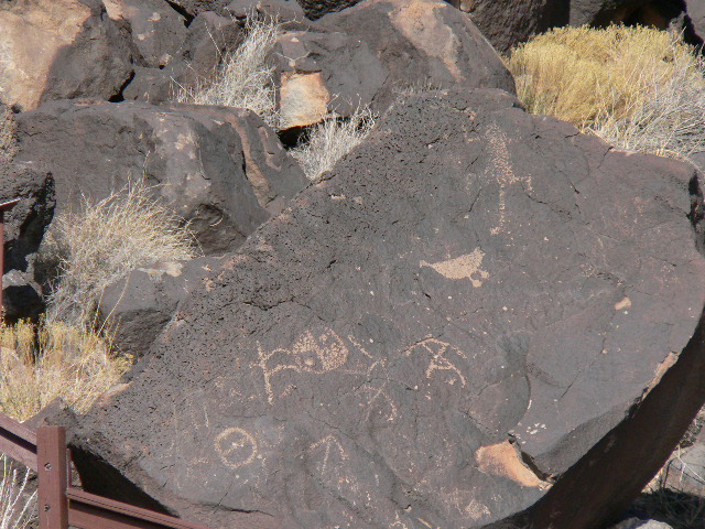
This line of unique volcanoes is located on Petroglyph National Monument, a 7,236 acre (29.28 km2) park created in 1990 to preserve the unique cultural and natural resources including the volcanic cones, “archaeological sites and an estimated 25,000 images carved by native peoples and early Spanish settlers.” [1]
The Petroglyphs were etched on the volcanic rocks, rocks whose minerals oxidized to form the desert varnish coating on the surface. However, do not expect to see petroglyphs near the volcanoes and the trails to the west that lead to them. They are found on the east slope of the mesa; the western portion of the park offers “a lesson in the greater volcanic geology and creation of the National Monument.”[2]
The Rift between us
The Albuquerque volcanoes are a relatively recent addition to the Rio Grande Rift Valley’s history, their advent being a direct result of the rift action.
This volcano story began long before the eruptions about 150,000 years ago (some sources estimate 130,000 years ago). Beginning 25 Million years ago the earth’s crust in New Mexico was “sporadically stretched and thinned between the Colorado Plateau… to the west and the Great Plains … to the east.” At the same time (geologically) during the rifting, the Sandia, Manzanita, Manzano, and Los Pinos Mountains began uplifting along the east side.[3]
|
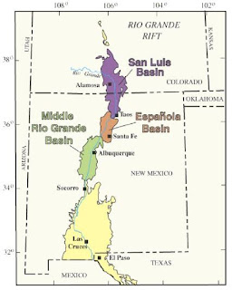
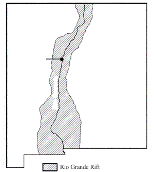
Map of Rio Grande Rift region showing rift basins (from USGS).
|
Rifting is not a ‘smooth’ process and results in a series of basins rather than a single long depression. Albuquerque is in one of these basins and was slowly filled with sediments from rivers and streams originating to the north and west. The sediments that filled the basin are known as the Santa Fe Formation. As the rift deepened, the rivers and streams eventually ran north to south and finally merged to create the Rio Grande. This formation of the Rio Grande (river) valley occurred about 1 million years ago.[3]
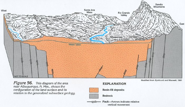
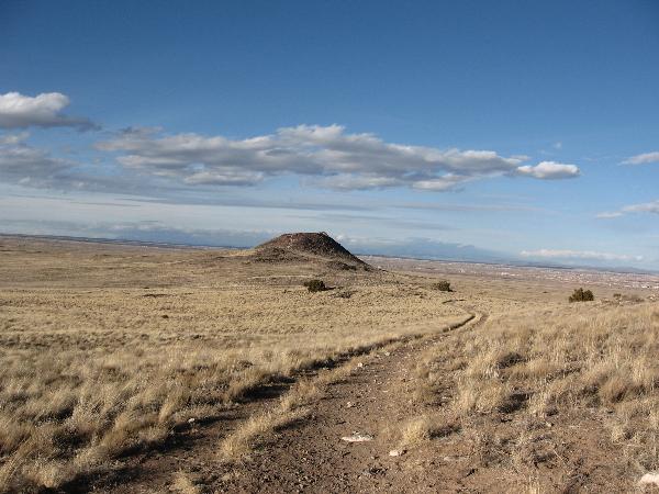
Today the rift manifests itself in the Albuquerque area over the 40 miles between the Sandias and the Rio Puerco.

The way was opened
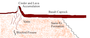
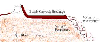
With the spreading crust creating an unstable area subject to earthquakes, and with the thinned crust in the rift valley, the stage was set for an eruption! If you were hoping for a big explosion, unfortunately this was not the case. A five-mile long deep crack (below the surface) in the crust, or fissure, was likely opened by an earthquake and magma arose to the surface. As this was a ”non-violent fissure eruption, lava flowed eastward in a sheet-like fashion and covered the Santa Fe Formation.” This was now about 150,000 years ago. The cooled lava is the black basalt rock you see in the National Monument.[4]
The cooled lava then blocked the fissure except for in a few places, vents, where “cinder and lava accumulated creating the volcanic cones we see today.” On the east slope of the mesa, the basalt rock broke apart leaving tons of materials for the ancient artists.[4]
Scoria? Spatter?
Although fissure eruptions are not uncommon and can be seen in Hawaii and Iceland, the fissure that gave us this line of scoria and spatter cones is unusually long. Scoria cone, or cinder cone volcanoes are typically steep conical hills. The rock fragments contain numerous gas bubbles "frozen" into place as magma exploded into the air and then cooled quickly.[5]
Similarly spatter cones are formed when the erupting lava contains enough explosive gas to prevent a lava flow, but not enough to shatter it into small fragments. The lava is torn into liquid hot clots by expanding gasses called spatter. When the spatter that has solidified accumulates around a vent it is called a spatter cone. “A spatter cone is formed of molten lava ejected from a vent somewhat like taffy. Expanding gases in the lava fountains tear the liquid rock into irregular gobs that fall back to earth, forming a heap around the vent. The still partly liquid rock splashes down and over the sides of the developing mound is called spatter. Because spatter is not fully solid when it lands, the individual deposits are very irregular in shape and weld together as they cool, and in this way particularly differ from cinder and ash.”[6]
Dr. Larry Crumpler, Curator of Research, Volcanology & Space Science at the NM Museum of Natural History and Science, wrote at this link that some of the Albuquerque volcanoes, including Vulcan, were “cones formed from spatter and thin lava flows coating an interior of cinder.”[7]
To log this EarthCache:
0. If you don't know how an EarthCache is different and why we didn't put a container here on NPS land, read this.
1. Review the park regulations page.
2. Hike from the Petroglyph National Monument Day Use area [Parking/Trailhead waypoint] to the posted coordinates just north of and below Vulcan’s summit. In your log, post a photo of yourself and/or your GPSr with one or more of the volcanoes in the background nearby. As of 1 January 2011, photographs are optional, but we'd still like to see what you saw!
As the Park Service notes, “Ancestral and Modern Pueblo peoples believe that hiking to the top of the volcanic cones desecrates this landscape. Please respect this belief by not climbing on or to the top of the volcanoes.“ Please stay on established trails as you will not need to hike to a summit to log this EarthCache. The trail loops around the summit.[8 ]
If you start and return to the trailhead at the NW corner of the lot, the distance is just over 2 miles round trip. If you loop around the cone and over Black to the trailhead in the SE corner, plan closer to 2¾ miles with more elevation changes. If you park near the outer gate near Atrisco Vista Boulevard (formerly Paseo del Vulcan), then add an additional quarter mile each way.
For your hike it is also worth noting that “this area is fully exposed, with no cover from the elements. Lightning can strike at anytime so please keep the weather forecast in mind. Weather can also change within minutes.”[2] Take Drinking Water!
3. On your hike look for evidence of scoria (rock fragments containing numerous large gas bubbles) and/or spatter (heaps around the vent or irregular shaped deposits that may be welded together). Describe (by name) the rocks you saw, or (easier) post an optional photo with the rock type named in the caption or description. I saw (I think) spatter evidence on the south-facing slope near the top. Can you find any other? Volcanic basalt rocks with a white-deposit coating are not evidence of either, but caliche, a calcium carbonate substance which is described on the national monument website.
4. Bonus Question: Petroglyph NM is 7,236 acres. Suppose that the lava flows covered 10,000 acres to a depth of 10 feet, and taking a uniform specific gravity of 3 for the basalt, roughly how much lava flowed from the fissure? Adding in the volume of the five cones is trickier without knowing their heights, but you can make reasonable guesses for those and add them in too if you like.
If you don't plan to answer #3 by using one or both of the magic words in your log and/or photo, then please don't post a found it log. We will send friendly reminders but eventually we'll delete your log.
The placement of this EarthCache was approved by the management of Petroglyph National Monument. Thank you!
References (updated 1 July 2015):
- Wikipedia, "Petroglyph National Monument", http://en.wikipedia.org/wiki/Petroglyph_National_Monument
- Pro Trails® "Albuquerque Volcanoes - The Three Sisters: 2.0 miles", http://www.protrails.com/trail/244/petroglyph-national-monument-albuquerque-volcanoes-the-three-sisters"
- Crumpler, L. S., Newsom, J., and Aubele, J. 2004, "Albuquerque's Geoscape": poster, http://www.joannewsom.com/AlbuquerqueGeology/ [dead link]
- National Park Service, "Geology: Designer of the Land", http://www.nps.gov/petr/planyourvisit/geology.htm
- USGS Volcano Hazards Program, "Photo glossary of volcano terms: Cinder cone", https://volcanoes.usgs.gov/vsc/glossary/cinder_cone.html
- Wikipedia, "Volcanic cone", http://en.wikipedia.org/wiki/Volcanic_cone
- New Mexico Museum of Natural History and Science, "Albuquerque Basin Volcanic Field", http://nmnaturalhistory.org/albuquerque-volcanic-field.html
- National Park Service, "The Volcanoes", http://www.nps.gov/petr/planyourvisit/volcanoes.htm