Hawai'i Volcanoes National Park - Pu‘u Huluhulu EarthCache
Hawai'i Volcanoes National Park - Pu‘u Huluhulu
-
Difficulty:
-

-
Terrain:
-

Size:  (not chosen)
Related Web Page
Please note Use of geocaching.com services is subject to the terms and conditions
in our disclaimer.
Aloha and welcome to Hawai‘i Volcanoes National Park
Earthcaching Program. This earthcache site is available year round.
This cache is on trail. Please do not travel off trail for your
safety and preservation of resources. There is a trail guide
available for this hike at the Hawaii Volcanoes Mational Park
website: nps.gov/havo or link to it here:
http://www.nps.gov/havo/planyourvisit/upload/mauna_ulu_trail_guide.pdf
Pu‘u Huluhulu, a forested hill in a lava field located in
Hawai‘i Volcanoes National Park.
Information regarding Pu‘u Huluhulu and the Mauna Ulu
parking lot area.
The main trail to access this cache is the Napau Trail. There is
free parking at the trailhead in the Mauna Ulu parking lot. Pets,
bicycles, and pack animals are not permitted on this trail. Camping
is permitted only at Napau Campground. Permits are required for
camping and hiking beyond Pu‘u Huluhulu.
• Pu‘u Huluhulu is open 24 hours.
• All plant material, rocks, animals, and historical features
are protected by law and may not be collected or disturbed.
Safety information:
- Prepare for hot, windy, and rainy weather.
- Depending on the weather, volcanic fumes may be present.
- If you have heart or breathing problems, avoid this trail.
- Hiking this trail at night is permitted. Bring a good flashlight,
extra batteries, and set out before sunset.
Kilauea Visitor Center Information:
- Open daily from 7:45 AM – 5:00 PM.
- Hawai‘i Volcanoes National Park
- Phone number: 808-985-6017
- In emergency: dial 911
Geological Information
Leaving the parking lot you walk down a road, not just any road,
but a road that was used over 80 years ago; this was the Chain of
Craters Road. Kilauea is a dynamic and changing place and where the
cache takes you will show you how.
Picture yourself here 40 years ago. The only sounds you here are of
birds and the occasional car driving by; a calming place untouched
by society and by man. But that soon changes. In an instant of time
the sound of birds is over taken by the roar of an eruption. The
ground cracks and breaks, the surface you’re standing on
becomes unstable as magma approaches the surface. The smell of
gasses soon fills your senses and you know an eruption is imminent.
This was how the eruption of Mauna Ulu, began its five year
eruption.
Walking along the trail to Pu’u Huluhulu sights of how lava
burned through the rainforest are seen. As the trees are covered in
lava they burn and create methane gas, the methane gas builds, and
BOOM!!! The rocks explode up and fragments of rock fly into the
air. As the lava hits moistures laden ‘Ohi‘a trees,
some of the lava is frozen around the trees forming erect
“lava trees” or sunken tree molds. There are places
where the rainforest did not burn. These areas are called
kipuka(s), areas that were not burned or destroyed by lava flow. In
some cases these kipukas can be hundreds of years old and these are
the best places to find old growth rainforests. Where this cache
is, is one example of that.
Remember the eruption that was mentioned earlier? This is the cone
you see from the cache. On May 24, 1969, fissures from here all the
way across the lava field to where you started opened up in a
northeast to east direction. The episodes that formed Mauna Ulu had
fountains as high as 1900 ft, but this was not the only type of
flow. Not only did the lava come out as curtains and flow, but as
you look out towards Mauna Ulu, you see what a lake of lava was!
This lava lake formed as lava pooled on the flanks of Mauna Ulu.
The sides cooled faster than the middle and built levees. These
levees grew as the liquid rock splashed and cooled along the edge.
As you can see, the lava drained out of the lake, as some of the
levees are higher then the “pond”. Looking towards the
summit there’s a channel. This is how lava came down the
slopes of Mauna Ulu. If the channel would have crusted over then
there would have been a lava tube.
The summit is a hazardous area. The crater of Mauna Ulu is over 350
feet deep. The edge is weak as can be seen by the fractures in the
crust. The active sulfur and steam vents that you see are a direct
link with the magma chamber. Beneath our feet magma is traveling
from the summit of Kilauea toward Pu‘u ‘O‘o.
These sulfur vents can precipitate different types of minerals such
as; sulfur, gypsum, calcium carbonate, and even opal. This cone is
considered active!
Will Mauna Ulu erupt again? Only time will tell. But one thing that
is for sure is that the species of plants and animals will continue
to adapt to the ever changing conditions of this volcano. That even
in our short lifetime, we can watch the creation, death, and
re-birth of this unique environment. It is with that understanding
that the impacts that we make as humans can have life changing
effects as well. Continue to hike the many different trails at
Hawai‘i Volcanoes National Park, but please leave only
footprints and take only memories. The rock here is basaltic in
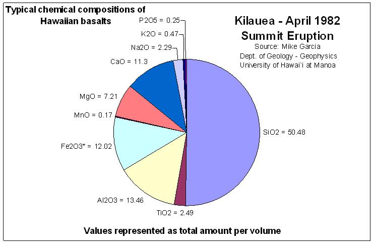
composition.
There are two main chemical make-ups of these rocks, alkalic and
tholeittic. The majority of lavas that make up the islands are
tholeittic in composition. The average make up of Hawaiian Basalt
for summit eruptions is between 47 - 50% SiO2, 12 - 13% Al2O3, 13%
FeO, 6 -9% MgO, 10 - 11% CaO, 2% TiO2, 2% Na2O, and the remainder
are all less than 1% of P2O5, K2O, MnO, and other trace
elements.(Garcia, 2008)
To Log this EarthCache, please answer the following questions
via the park's profile:
1. Which is older, Pu’u Huluhulu or Mauna Ulu? Why do you
think so?
2. At the monument at the top, what is the farthest feature that it
points to?
Sources:
Frey, F. A.; Garcia, M. O.; Wise, W. S.; Kennedy, A.; Gurriet, P.;
Albarede, F., 1991, The evolution of Mauna Kea Volcano,
Hawai‘i Petrogenesis of Tholeittic and Alkalic basalts,
Journal of Geophysical Research, V. 96, I. B9, p.
14375-14375.
Garcia, Mike, 2008, University of Hawaii at Manoa, personal
communication and data.
Hawai‘i Volcanoes National Park, 2008, Hawai‘i
Volcanoes National Park, National Park Service, P.O. Box 52,
Hawai‘i National Park, HI, 96718.
Hazlett, Richard W., 2002, Geological Field Guide Kilauea Volcano,
Hawai‘i Natural History Association.
Additional Hints
(Decrypt)
Guvf rnegupnpur vf ybpngrq ng gur gbc bs Ch‘h Uhyhuhyh. Gurer vf n zbahzrag ng gur gbc.