Parfrey's Glen State Natural Area (No. 1)
The listed coordinates are for parking.
As this is an EarthCache there are special logging requirements and NO container to find. Logs not meeting the posted requirements below may be deleted.
From the parking area it is a short hike across a field and over several footbridges into ever deepening woods to your final destination. The sounds of birds and a babbling brook will be your constant companion. A park sticker is required and pets are NOT allowed. Open daily from 6am to 8pm, Parfrey's Glen is managed by the DNR and was designated as Wisconsin's first State Natural Area in 1952. As this is an SNA, PLEASE STAY ON THE TRAIL.
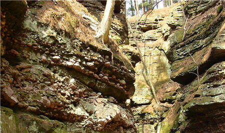 The glen walls you will be passing through were formed by Cambrian-age sandstone which was deposited when this area was covered by a shallow inland sea 530 million years ago. As you can see in the picture below, Baraboo Quartzite is studded and sometimes layered throughout the Cambrian sandstone. While there is no obvious contact between the Cambrian sandstone and the much older quartzite, a conglomerate of the two can be found here. Hurricane fueled sea currents likely washed the quartzite to this area from nearby sources where it eventually embedded itself into the sandstone. Later on glacial melts played a part in bringing the quartzite to the glen. This glacial melt also played a part in the actual cutting of the gorge you see here as the meltwater flowed in abundance throughout the area.
The gorge continues to weather and erode due to several ongoing forces such as:
Root pry: Tree roots claw and dig their way while chipping away at the cliff walls.
Frost: When ice freezes and thaws rock is broken lose from the walls.
Running water: The movement of water and sediment change the shape of the gorge's base.
***2008 & 2010 FLOODS***
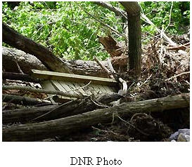 In June of 2008 record rainfalls in the area showed us exactly what kind of power water has. Not only did the rains cause the complete draining of nearby Lake Delton when it bust through its banks, the rains also changed the shape of this glen shifting boulders and creating landslides. This park used to have an extensive series of elevated boardwalks which extended to the end of the glen where a small waterfall is located. The raging storm water destroyed those boardwalks and forever changed the path of the water running through the glen.
In 2010 the area was hit by hard rains and once again the park was closed for over a year while repair work was done. Both of these massive rains and resulting floods help to demonstrate the power of erosion which continue to shape this gorge.
Logging Requirements:
E-mail me an estimation of the height of the bluff at it highest point; now optional, take a photo of one of the forms of erosion mentioned on the cache page.
Posting photos is the best way to thank an EarthCache developer and to encourage others to visit.
The Geocache Notification Form has been submitted to Thomas A. Meyer Conservation Biologist, State Natural Areas Program. Geocaches placed on Wisconsin Department of Natural Resource managed lands require permission by means of a notification form. Please print out a paper copy of the notification form, fill in all required information, then submit it to the land manager. The DNR Notification form and land manager information can be obtained at: http://www.wi-geocaching.com/modules.php?name=Wiki&pagename=Hiding%20A%20Cache
References:
http://www.dnr.state.wi.us/org/land/er/sna/sna1.htm
http://www.gwaihir.org/hiking/wi/parfrey.html
http://www.uwgb.edu/dutchs/geolwisc/geostops/ParfreysGlen.HTM
http://www.uwm.edu/~caberg/mtp5/virft/glacial/parfreys.shtml
http://www.dnr.state.wi.us/org/land/parks/regions/scr/parfrey.html
|
 IATCC is the cache designation to highlight a series of EarthCaches along the Ice Age National Scenic Trail grouped into a special category called "ColdCache." IATCC is the cache designation to highlight a series of EarthCaches along the Ice Age National Scenic Trail grouped into a special category called "ColdCache."
The Ice Age Trail is one of eleven (11) National Scenic Trails designated by the National Park Service. This unique trail is entirely within the state of Wisconsin and follows along the terminal moraine of the most recent glacier.
This project is supported by the Ice Age Trail Alliance. The goal is to bring more visitors to the trail and promote public awareness, appreciation, and understanding of Wisconsin’s glacial landscape.
More information on the Ice Age Trail Atlas, the ColdCache Project and Awards Program is available at: www.iceagetrail.org/hiking-awards-and-programs.
|