Heads Up! Traditional Geocache
-
Difficulty:
-

-
Terrain:
-

Size:  (regular)
Please note Use of geocaching.com services is subject to the terms and conditions
in our disclaimer.
A cache on the Mountain-Bay Trail. A 2.5-mile round-trip walk or
bike from the parking coordinates. Posted parking coordinates are
highly recommended.
This cache is placed at a location that can be quite interesting
depending on when you are there. The public Mountain-Bay Trail runs
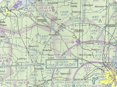
perpendicular to the end of the runway of the Pulaski Airport (also known as
Carter Airport, code 92C). If you are on the trail at the right
time and the winds are blowing anywhere from about 210 to 30
degrees on your compass, a plane will literally fly just 100 feet
or so above your head to land on either the asphalt or grass strip,
or even lower if "gotta fly" is flying and decides give you a buzz
job.
Now of course, geocaches can't be placed on or near an airport, so
this is placed far enough away to keep you out of trouble. It is
also placed with the knowledge and consent of the airport owner.
Regardless, please be aware that the cache is placed on public
land, just a few feet off the trail, and is a regular ammo can to
make it easy to find. As always, do not go onto any private
property to hunt this cache.
The Geocache Notification Form has been submitted to Gary Hanson of
the Wisconsin DNR. Geocaches placed on Wisconsin Department of
Natural Resource managed lands require permission by means of a
notification form. Please print out a paper copy of the
notification form, fill in all required information, then submit it
to the land manager. The DNR Notification form and land manager
information can be obtained at:
http://www.wi-geocaching.com/hiding
Additional Hints
(No hints available.)