This EarthCache brings you to an unlikely spot in the midst of the
urban environment where you are able to view one of nature’s most
efficient methods of flood control and water quality control – a
marsh. The marsh, as described in detail below, provides a place
for excess water to go during times of high flow. It also allows
sediment and pollutants to be filtered out of runoff water before
getting into the Root River. Please enjoy the area.
ROOT RIVER
The Root River is a river, about 35 mi (55 km) long, that flows
to Lake Michigan in Racine. Racine and Racine County are named for
the river, as racine is the French word for root.
The Root River Watershed is located in portions of Waukesha,
Milwaukee, and Racine Counties, and drains almost 2/3 of the entire
Root-Pike Basin. (198 square miles). There are a total of 117 miles
of rivers and streams in the Root River Watershed.
The headwaters begin in west central Milwaukee and eastern
Waukesha counties. From there, the river flows southeast, picking
up contribution from eight sub-watershed, and ultimately emptying
into Lake Michigan in the City of Racine.
The Root River Watershed ranges from heavily urbanized at the
headwaters and mouth, to agricultural use in the middle drainage
area and back to urban near the City of Kenosha. All told,
agricultural uses dominate land usage, at 49 percent, followed by
grasslands at 16 percent. Urban land uses cover about 14 percent of
the land area. The remaining land uses consist of five percent
wetland, and five percent barren and shrubland. Municipalities
within the Watershed include: the Cities of Franklin, Greenfield,
Milwaukee, Oak Creek, West Allis, Racine, New Berlin, and Muskego;
Towns of Paris Caledonia, Dover, Mt. Pleasant, Raymond, and
Yorkville; and the Villages of Greendale, Hales Corners and Union
Grove.
WIMMER MARSH
Marshes are composed of both seasonal and emergent wetlands.
They are often found meandering throughout the state in conjunction
with river floodplains, at upper ends of lakes and reservoirs, and
in other lowland areas. Seasonal wetlands often called “moist-soil
wetlands” are shallow marsh areas that dry and reflood annually.
Over 150 species of birds use this type of habitat and it is
especially attractive to migrating ducks and geese. Emergent
wetlands are flooded through much of the growing season and contain
vegetation that emerges above the water surface. These plants
include perennial vegetation like cattails, rushes, and sedges.
They also provide feeding, brood rearing, and resting habitat for a
variety of birds as well as a wide range of other wildlife. Managed
in conjunction with each other these two wetland types provide
diverse habitat for many species of wildlife.
There are four wetland ecosystem types – marshes, swamps, fens
and bogs – and each of them is different.
Of all the wetland types, the marsh is the most productive.
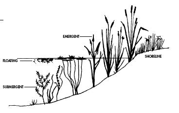
Marshes are shallow wetlands less than two metres deep. In
different areas of the marsh, different plant communities thrive.
In deep water areas, submergent and floating leaved plants grow. In
the shallower portions of the marsh, emergent plants can be found.
Marshy areas like this may also develop in the shallow parts of
lakes and streams.
Marshes provide a wide range of benefits to people as well as
wildlife. As our rivers rise above and beyond their banks, adjacent
lowlands become flooded. The occurrence of high water is followed
by a slow release of floodwater, leaving behind rich alluvial soil.
This rich nutrient influx provides, for example, the base for
future plant production along with rich mixes of macro-invertebrate
bugs; both favorite foods with different nutritional importance to
both waterfowl and hundreds of other species of wildlife. All types
of wetlands act as filters to keep our rivers clean and return
purified water back to aquifers. When floodways are expanded by
restoration of wetlands, these wetlands also help reduce the
severity of downriver floods by storing and slowly releasing
floodwaters back into the rivers.
Marshes, like other wetland types, have been severely altered
and/or destroyed by humans throughout our history. Many of the
original wetlands that once existed are now gone. These wetlands
were extensive and only a fraction now remains.
POSTING REQUIRMENTS
In order to claim this Earthcache, you must meet the following
requirements:
1. Please post a picture of you and/or your GPS with the marsh
or the river in the background. Also in your online post, please
indicate which (if any) types of wild life you encountered. A photo
of your group doing the second posting requirement will also
satisfy this requirement.
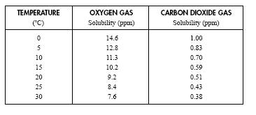
2. Temperature and dissolved oxygen are two elements in water
which affect how much aquatic life the water can support. Measure
the temperature of the root river at the time of your visit, and
estimate the amount of dissolved oxygen in the river at the time of
your visit.
The temperature of a stream can be changed by several things,
including:
how much sunlight a stream gets--if it is shaded or not by
vegetation
if warm water is being released into the stream by industries or
storm runoff from the cities
if there are particles in the water, such as dirt or algae, the
temperature can increase because the particle can absorb more solar
energy.
The Dissolved Oxygen levels may be affected in the following
ways:
a change in the water temperature
turbulence in the stream mixes air and water and increases the
DO--water is turbulent when the flow is unstable, such as over
rapids or waterfalls
organic wastes, such as from a wastewater treatment plant or
food processing plant, may decrease the amount of DO in the
stream.
some nutrients released from farm fertilizers and runoff can
cause algae growth to increase and will eventually lead to
decreases of the dissolved oxygen.
Notes:
An example of how the amount of dissolved oxygen in water has a
significant effect on fish (and other animal) health and growth
rate is shown on the table below. The table shows how trout growth
can be slowed by a reduction in the amount of dissolved oxygen in
water. Shallow wetlands like marshes and swamps do not support
trout. Only species that can withstand lower oxygen levels and
higher water temperatures, such as pike and sticklebacks, are found
there. When wetlands are too shallow they may freeze to the bottom
in winter and oxygen levels drop to very low levels. Fish dieoffs
will occur under such anoxic conditions.
