On top of Old Baldy EarthCache
-
Difficulty:
-

-
Terrain:
-
Size:  (not chosen)
Please note Use of geocaching.com services is subject to the terms and conditions
in our disclaimer.
One of the tallest sand dunes at WhiteFish Dunes State Park, WI.
Plan a minimum of two hours to hike forested trails, boardwalk and
stairs to an elevation of 93 feet. Insect repellent is suggested,
as well as comfortable footwear for hiking and climbing.
The sand dunes at Whitefish Bay are the largest deposits of sand
along the Lake Michigan shore in Door County, and are among the
highest in the state of Wisconsin. " Old Baldy" rises 93 feet above
the lake level.
During your visit, you will learn how sand dunes change over time
and how human activity can impact sand dunes.
How do Sand Dunes Form?
“Little drops of water, little grains of sand
Make the mighty ocean, and the pleasant land.”
Julia A. Fletcher Carney
From Little Things 1845
How are the sand dunes along the shores of Lake Michigan formed?
While water and sand are part of the answer, the wind is the
important force in creating sand dunes.
If you have visited the Lake Michigan shores, you know the winds
can range from gentle puffs to ferocious gales. Loose, light,
grains of sand on the shore get caught up in the wind, and are
carried inland. The downwind movement of the particles of sand is
called saltation. As the wind slows over the land, the grains drop
to the earth.

Saltation moves small particles in the direction of the wind in a
series of short hops or skips.
This sand “relocation” happens over and over again, until the pile
of sand grows into a sand dune. Sand dunes are constantly forming
and moving!
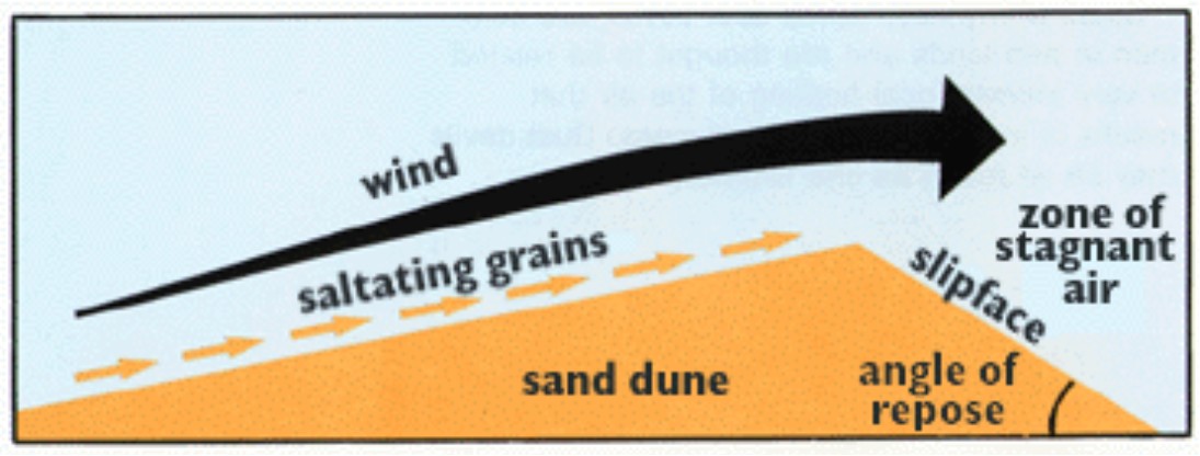
Wind-blown sand moves up the gentle upwind side of the dune by
saltation or creep. Sand accumulates at the brink, the top of the
slipface. When the buildup of sand at the brink exceeds the angle
of repose, a small avalanche of grains slides down the slipface.
Grain by grain, the dune moves downwind.
Diagrams in this article were taken from the
U.S. Geological Survey website.
To successfully complete this EarthCACHE challenge, please answer
the questions and complete the following task. Please note a
digital camera is required for task 3.
1. Why is the top of Old Baldy sand dune concave? What caused this
unusual shape?
2. List 3 things that whitefish Dunes State Park is doing to
protect the sand dunes.
3. Take a picture of yourself and your GPS unit on top of the
observation deck while you are facing Lake Michigan. Please e-mail
this photo to log your visit to Old Baldy.
Prior to your visit, please visit the following sites for
information on the formation of sand dunes.
http://www.great-lakes.net/teach/geog/shoreline/shore_3.html
http://www.nps.gove/archive/whsa/Sand Dune Geology.html
Podcast available at
http://www.travelistic.com/video/show/7502/Door-County-WI-Travel-Show---Whitefish-Dunes-State-Park
Large sand dunes aren't common in Wisconsin and occur only in a
few locations along Lake Michigan, Lake Superior, and inland. One
of the principle purposes of Whitefish Dunes State Park is the
preservation of the dunes and the unique plants that depend on
them. Please stay on marked trails while hiking in the dune area of
the park. By staying on the trail you will help to preserve the
dunes and the rare plants living here.
Excellent book sources are also available:
Dott, Robert H. and John W. Attig Roadside Geology of Wisconsin
Missoula, MT: Mountain Press Publishing Company, 2004.
Skadden, Bill The Geology of Door County, Sturgeon Bay, WI: golden
Glow Publishing Company, 1978
Additional Hints
(Decrypt)
Cnex oebpuher naq Angher Pragre rkuvovgf pna uryc nafjre dhrfgvbaf 1 naq 2.