 UNESCO Geopark Bergstrasse Odenwald – Felsenmeer
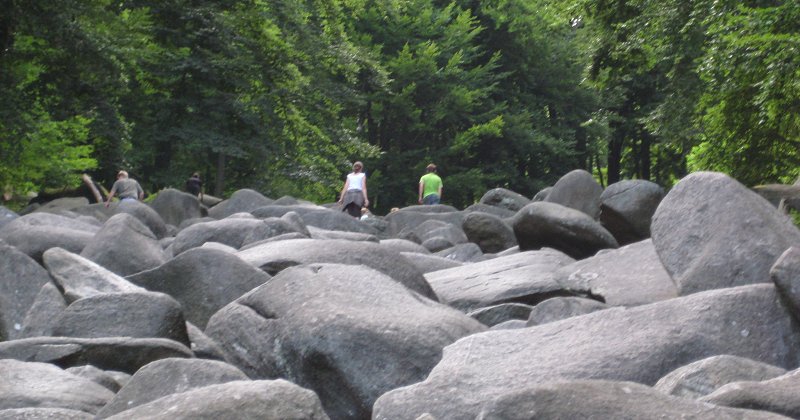
Jahrmillionen haben diese Landschaft zwischen Rhein, Main und Neckar geformt. Die Erdgeschichte ist zum Greifen nah. Jeder Stein erzählt ein Stück davon. Im kristallinen Odenwald durchwandert man Gesteine, die einst Kilometer tief in der Erde beim Zusammenprall zweier Urkontinente entstanden sind. Gewaltige Absenkungsprozesse schufen den Oberrheingraben und die steilen Hänge der Bergstrasse. Die Felsen im Felsenmeer waren einst eine Schicht Granit, die in einem Bett aus Geröll lagen. Über viele Jahrmillionen wurde die Granitfelsen aus dem Geröll gewaschen und setzen sich langsam ab. Übrig blieben gewaltige Felsen, die im weichen Untergrund nicht splitterten, wie zB die Schotterflächen von Endmoränen.
Die Entstehung des Felsenmeers:
In der Karbonzeit fand eine Kontinentkollision statt mit Bildung von Gesteinsschmelzen. Quarzdiorit-Intrusion in 12-15km Tiefe.
Vor 340 Million Jahren:
Der Felsberg bildet sich als Teil des Variszischen Gebirges, der "Nahtstelle" der kollidierenden Kontinente
vor 50 Millionen Jahren:
In der Tertiärzeit Abtragung der überlagernden Gesteinsschichten und Freilegung des Intrusivkörpers
vor 10 Millionen Jahren:
Intensive Subtropische Verwitterung - Wollsackverwitterung
vor 2,5 Millionen Jahren bis vor 10000 Jahren:
In der Pleistozänzeit Versteilung des Reliefs durch eiszeitliche Talbildung. Lockermaterial wird weggespült. Dioritblöcke bilden an den Talflanken Blockmeere.
Aber nun zum Cache.
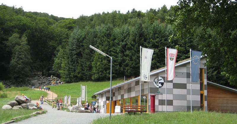
Beginne deine Wanderung am Felsenmeer-Besucherzentrum in Reichenbach. Das Auto kann man dort den ganzen Tag für jetzt mittlerweile 4 (war mal 3, war mal 2) Euro parken. Das Terrain wechselt von 3,5 wenn du die Felsen läufst, auf 2,5 wenn du die Wege benutzt. Achtung! Die Felsen sind sehr glatt wenn sie feucht sind! Kalkuliere 2-3h für die gesamte Wanderung. Viel Spaß!
Folgende Logbedingung muss erfüllt sein:
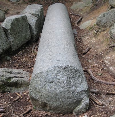
1. Gehe zur Riesensäule und schätze das Gewicht und die Länge.
2. In welchem Jahrhundert wurde die Felssäule von den Römern behauen?
3. In welchem Jahrhundert fiel die Säule um, bzw wurde sie umgestoßen? (Da es immer wieder Probleme gibt: Die stand mal und es war nicht das Jahr 1477. Eine Tafel am Parkplatz, oder das Internet hilft hier weiter)
4. Mache ein Foto von deinem GPS und der Riesensäule. Optional darfst du natürlich auch mit drauf sein
5. In welchem Jahr wurde die neue Holzbrücke über das Felsenmeer errichtet? (man muss schon selbst hingehen und es ablesen, 1989 ist falsch)
6. Es gibt viele Felsen, die spezielle Namen erhalten haben, wie zB die „Riesensäule“. Sende mir mindestens zwei weitere Namen von speziellen Felsformationen.
Logeinträge ohne Foto, oder ohne Email an mich werden gelöscht. Sende deine Antworten an meinen GC-EMAIL-Account. NICHT ins Nachrichten-Center! Danach kannst du sofort loggen. Ist etwas falsch, melde ich mich bei dir.
 UNESCO Geopark Bergstrasse Odenwald – Felsenmeer
The landscape between the river Rhine, Main and Neckar took millions of years to evolve. Earth history lies just underneath your feet. Each rock can reveal a part of this long story. The rocks you find on a walk trough the Crystaline Odenwald at the Felsenmeer (Sea of Rocks) were formed several kilometres deep in the earth’s crust during the collision of two ancient continents: The Rhine Rift Valley and the steep slopes of the Bergstrasse were formed during huge downward movements of the crust. The rocks of the Felsenmeer were once a layer of granite lying in a bed of gravel. Over many millennia, the elements weatherd the granite down. The gravel below washed away, leaving the huge rocks to sink into the soft soil beneath.
The genesis of the “Felsenmeer”:
Carboniferous time:
Continental drift with formation of stone melting magma hearth
340 million years ago
The “Felsberg” was build as a result of orogenic movements on
a fault-plane of two colliding continents.
Quartz diorite intrusion 12-15 kilometer below.
50 million years ago
Tertiary denudation of the upper rock formation. Exposure of the intrusive rock corpus.
10 million years ago
Intensive subtropical weathering and decomposition in quartzite blocks
2.5 million years - 10000 years ago
At pleistocene time moving the rocks into a steeper relief because of ice age valley
formation. Loose masses washed out. Diorite blocks building “sea of rocks”
at the mountainside.
But now more about the cache:
Start your trip to the rocks at the Reichenbach Geopark Felsenmeer Visitor Centre. The parking fee is 2 Euros for the whole day. If you climb the rocks then the terrain difficulty is 3.5-star, if you use the trails then the difficulty is 2.5-star. Take extra care climbing the rocks. Don’t climb the rocks when they are wet. Calculate 2h - 3h in time to walk this Park site. Have fun!
To log, please answer:
1.) Walk to the “Riesensaeule” (giant column) and appraise weight and length.
2.) In which century was it shaped by the romans?
3.) In which century was it knocked down?
4.) Take a photo from your GPSr and the “Riesensaeule”
5.) Find the plaque at the wooden brigde over the Felsenmeer. Write down the opening year of the new brigde.
6.) There are more rocks with fancy names like “Riesensaeule” (giant column). Find at least two more fancy rock names (German or English names)
Logs without a picture upload or without sending the answers to my GC.com Email will be deleted! I'll try to give log-permission as soon as possible.