There are several approaches to the summit. If you use the
parking coordinates below, the round trip hike will be about 5.5
beautiful miles:

Park Here
N 39° 02.924
W 086° 15.001
Notice on the map above that there is an intersection of
trails about 1.3 miles into the hike; if you climb over the large
tree blocking the path (instead of going around), you will miss
it.
At 930 feet tall, Browning Hill (also sometimes known as
Browning Mountain, or Indiana's Stonehenge) is the 53rd highest
peak in Indiana.
It is known as stonehenge because of an unusual group of
sandstone blocks positioned in a circle at the west end of the
summit (the cache is located some distance away near the exact,
USGS summit of 930 feet).
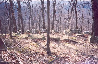
The blocks are a non-native siltstone, (Keokuk
limestone) hewn with right angles, and occasional angular fillets,
3-4 ft wide, 2-3 ft thick, and 5-15 ft long. The nearest Keokuk
limestone source is believed to be near Edwardsville, in Floyd
County, Indiana, a remarkable distance from Brown County, if the
stones were moved by manpower in pre-Columbian times. It is known
that Miami Indians come from Iowa to make use of this site for
certain ceremonies to this day.
The cache is in a small plastic jar covered with black
tape.