Guntersville Dam EarthCache
-
Difficulty:
-

-
Terrain:
-

Size:  (not chosen)
Please note Use of geocaching.com services is subject to the terms and conditions
in our disclaimer.
HYDROLOGIC
MODIFICATIONS
Guntersville
Dam
 The following cache will
bring you to the Southern side of Guntersville Dam. Here you will
find a man made Hydrologic Modification.
The following cache will
bring you to the Southern side of Guntersville Dam. Here you will
find a man made Hydrologic Modification.
Whether you notice it or not, water is continuously on the move
all around us. It’s falling to the land in the form of
precipitation. It’s moving across landscapes making its way to
streams. Streams are running to rivers and rivers are running to
oceans. Water is the ultimate recycled element thanks to the
hydrologic cycle, which constantly moves water from the
atmosphere–down to the planet’s surface and then back into the
atmosphere. When built the Guntersville Dam site was chosen for the
solid bedrock below. After creating a new channel for the river to
flow while the dam was under construction, the site was excavated
of all top soil, down to the limestone bedrock that would give the
dam the strength it would need to withstand the flood waters that
raged through this valley. Damming the river to control these
floods, has for the time, slowed the rivers natural ability to
meander through the valley below the dam and opening up the flood
plain below for agricultural development. The main area subject to
these floods is the Lacey Springs area south of Huntsville. Looking
at a aerial photo, you can see evidence of where the river once
flowed.
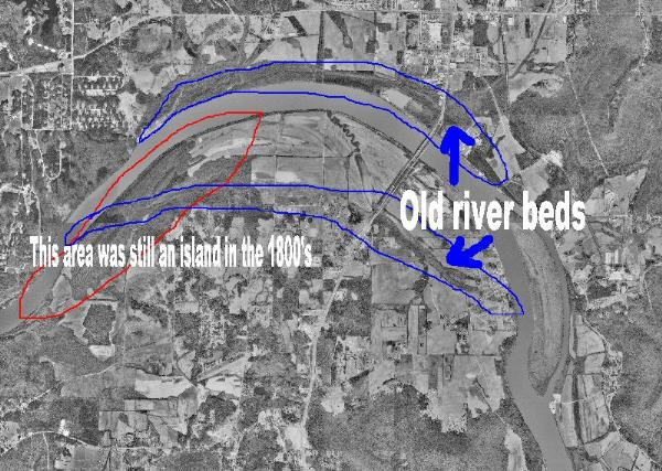 Visual evidence of the land
shaping powers of water.
Visual evidence of the land
shaping powers of water.
Before human modifications,
water "percolates" through many different elements, sand and dirt,
rocky and grassy areas, before reaching waterways like creeks,
streams and rivers. Each of these, help filter out pollutants,
sometimes they act as holding areas, creating standing water
waiting to go through the system. Man has since come along and made
hydrologic modifications, working around this natural flow, and
forcing water more directly into waterways, creating a large
reservoir, Guntersville Lake. Depending on Rain fall, the amount of
water passing over the dam will vary. All so if the turbines are on
the water flow here will change from day to day, in an attempt to
control flooding both up river and down. Water will still have its
way and each day continues to chance the face of our Earth.
Guntersville Dam was part of President Franklin Delano Roosevelt's
New Deal project, the Tennessee Valley Authority. Construction
started in 1935 and was completed in 1939.Guntersville lake now
provides almost 890 miles of shoreline and 67,900 acres of water
surface. The dam itself is 94 feet high and stretches 3,979 feet
across the Tennessee River. The Dam has two locks to handle
commercial shipping and recreational boating. The larger of
Guntersville’s two locks was built in 1965 to handle the growing
river traffic. Guntersville lake has a flood-storage capacity of
162,000 acre-feet. The generating capacity of Guntersville is
140,400 kilowatts of electricity.
The building of this dam not only brought precious jobs to the
area in the 1930's, it also brought electricity and the end of
flooding in the Tennessee Valley. It also brought with it numerous
recreational opportunities, including boating on the river and
lake, fishing, hiking, camping and many other outdoor activities,
forever changing the landscape in this region of
Alabama.
** Note Since 911, security
is much stiffer around all dams. Several areas are now off limits.
So please be aware and observe any No trespassing sings. As a whole
TVA Land is Public. The TVA Police are aware of this cache and
still may question you if they see you. So don’t be surprised. If
there is an issue, Captain Patterson on the TVA Police does know
about this Earth Cache.
Meander From Wikipedia, the
free encyclopedia
A hypothetical stream bed following a tilted valley. The maximum
gradient is along the down-valley axis represented by a
hypothetical straight channel. Meanders develop, which lengthen the
course of the stream, decreasing the gradient.
A meander in general is a bend in a sinuous watercourse, also
known as an oxbow loop, or simply an oxbow. A stream of any volume
may assume a meandering course, alternatively eroding sediments
from the outside of a bend and depositing them on the inside. The
result is a snaking pattern as the stream meanders back and forth
across its down-valley axis. When a meander gets cut off from the
main stream, an oxbow lake is formed.
To log this cache, you will have to complete a few requirements.
All requirements must be done with in 14 days of logging or it will
be deleted.
1) Take a picture of yourself or your geocaching group with the
dam in the background.
2) Calculate the flow rate in "Feet Per Second" for Tennessee
River at this location. This may be done by measuring a distance
along each of the rivers banks, floating an object from your
starting point to the ending point, and recording the time it takes
the object to float the distance. Once the "Distance" and "Time"
are determined, calculate the "Feet Per
Second".


Additional Hints
(No hints available.)