marish Multi-Cache
urban vlo: Jammer, maar helaas. Het einde van marish.
We bedanken iedereen voor de fijne logs, de foto's en de vele favorieten.
Vanmorgen ook daadwerkelijk de cache opgehaald.
Geogroet van ons.
-
Difficulty:
-

-
Terrain:
-

Size:  (regular)
Please note Use of geocaching.com services is subject to the terms and conditions
in our disclaimer.
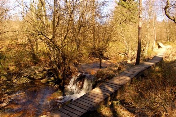
Marish is een 15 km lange multicache. De wandeling is voor 99% over onverhard pad en zeer gevarieerd. Het moeilijke van deze cache zit in de lengte en de paden en niet in het vinden van de tags of puzzelen voor de cache.
Marish is a 15 km long multi cache. The walk is for 99% unpaved path and divers. The difficulty of this cache is the length and not in solving puzzles or finding the tags.

marish
1-10 2023 gaat Marish het archief in!!!!!!!
ki
Deze cache is uitgezet door middel van tag's. Metalen plaatjes van 10 x 15 cm. waar het coördinaat van het volgende waypoint en een aanwijzing voor de cachelocatie zijn ingeponst. De tag's zijn lichtgroen gespoten. Als je de hints - gegeven bij de waypoints - gebruikt zijn ze makkelijk te vinden. Ze zitten op duidelijke plaatsen ( b.v. brug, infobord).
De route is 15 kilometer lang en gaat soms over smalle, natte en modderige paadjes. Goede schoenen zijn belangrijk en de route is niet geschikt voor rolstoelen, kinderwagens en kleine kinderen. Je komt langs of dichtbij een aantal andere caches (GC131RD, GC11FY6, GC11JVT, GC1XBJ5, GC1G78Q, GC17XPZ en GCGBVX).
Op de parkeerplaats staat een infobord. Dit is waypoint 01 en op de achterzijde zit de tag (nu weet je meteen hoe ze eruit zien). Vergeet niet steeds de aanwijzing voor de cache te noteren.
Net voor de parkeerplaats is een brug over een riviertje. Dit is de Trô Marêt en deze zullen we tot waypoint 06 stroomopwaarts volgen. Zorg dat je steeds het pad volgt dat het dichtst langs het riviertje loopt. In de vallei van de Trô Marêt kan de ontvangst wat slecht zijn, maar de waypoints zijn duidelijk omschreven en de tags makkelijk te vinden. Voor WP 04 is er zelfs een spoiler.
Bij WP 13 heb je alle informatie om de cache locatie te berekenen, er is daar een bankje. We raden aan om via WP 14 en WP 15 naar de cache te lopen. Vergeet niet bij "Additional Waypoints" te kijken naar de hints voor de verschillende waypoints. Na het vinden van de cache loop je het pad verder naar beneden af, aan het eind rechts en je bent weer op bekende weg.
. De cacheberekening. Noord A' (C*D).(E+G+I+L) Oost 006' K. (F+H+J+M)
This cache is made on basis of tags, metal plates of 10*15 cm, on which you can find the coördinates for the next WP and an indication for the final coördinates. The tags are light green. If you use the hints -given by the WP- they are easy to find. They are on obvious places (f.e. bridge, information board).
The route is 15 kilometres long and some path's are small, wet or muddy. After a wet period it can be slippery. Good walkingshoes are a must and the route is not accesible for wheelchairs, buggy's and very young children. During this walk you pass some other caches, or they will be in the neaberhood: GC131RD, GC11FY6, GC11JVT, GC1XBJ5, GC1G78Q, GC17XPZ and GCGBVX.
At the parkingplace you'll find an information board. This is WP 1 and on the back side you find the tag (now you know how they look like). Don't forget to write down the indication for the final coördinates.
Just before he parking place is a bridge over a little river. It's the Trô Marêt and we will follow it upstream until WP 06. Always follow the path closest to the river. In the valley of the Trô Marêt the receive of your GPS can be very bad, but the hints by the waypoints are very clear and the tags are easy to find. For WP 04 we made a spoiler photo.
At WP 13 you have all the information to calculate the final coördinates, there is also a bench. We suggest to walk through WP 14 and WP 15 for the final. Look at the "Additional Waypoints" for the hints of the next waypoint. If you found the cache you continue this path down, at the end you turn right and you are on a path you walked before.
. Cache-location: Nord A' (C*D).(E+G+I+L) East 006' K. (F+H+J+M)
La cache est construite sur base de plaquettes métalliques de 10*15 cm sur lesquelles se trouvent les coordonnées du WP suivant et un indice pour les coordonnées de la cache finale. Les plaquettes sont vert clair. Si vous utilisés les hints (indices) liés à chaque WP, ces plaquettes sont faciles à trouver. Elles se trouvent à des endroits évidents (par exemples un pont, un panneau indicateur, …)
La balade fait 15 km de long et certains chemins sont étroits, humides ou boueux. Après une période de pluie, ils peuvent aussi être glissants. De bonnes chaussures de marche sont nécessaires et les chemins ne sont pas praticables pour les fauteuils roulants, les voitures d’enfant et les jeunes enfants. Durant la balade, vous passez à proximité d’autres caches : GC131RD, GC11FY6, GC11JVT, GC1XBJ5, GC1G78Q, GC17XPZ and GCGBVX.
Au parking, vous trouverez un panneau d’information. Il s’agit du WP 1 à l’arrière duquel se trouve la première plaquette (Maintenant vous savez à quoi elles ressemblent). N’oubliez pas de noter l’indice pour les coordonnées finales.
Juste avant le parking, il y a un pont qui traverse une petite rivière. C’est le Trô Marêt que nous allons remonter jusqu’au WP 6. Toujour suivre le chemin le plus proche du ruisseau. Dans la vallée du Trô Marêt, la reception GPS peut être très mauvaise, mais les indices des WPs sont très clairs et les plaquettes faciles à trouver. Pour WP 4, une photo spoiler existe.
Au WP 13 vous avez toutes les informations necessaries pour calculer les coordonnées de la cache finale. Il y a aussi un banc. Nous vous suggérons de passer par les WP 14 et WP 15 pour la cache finale. Regarder la section "Additional Waypoints" pour les indices relatifs aux WPs suivants. Lorsque vous avez trouvé la cache, continuer à descendre le chemin et à la fin, vous tournez à droite et vous reviendrez sur un chemin que vous avez emprunté avant.
.. Cache: Nord A' (C*D).(E+G+I+L) Est 006' K. (F+H+J+M)
Bedankt/Thanks/Merci esc78 voor de Franse vertaling.
code for the banner:
<a href="http://www.geocaching.com/seek/cache_details.aspx?wp=GC1G2VB" target='_blank'><img src="http://img.geocaching.com/cache/5f60fe25-2bf6-411a-987b-047c63277b85.jpg"></a>


Additional Hints
(Decrypt)
Jnlcbvag 4 frr fcbvyre, JC4 ibve cubgb fcbvyre
Pnpur:
Baqre fgrra, ovw nstrmnntqr obbz.
Haqre fgbar, ol jung vf yrsg bs n gerr.
Fbhf har Cvreer, à yn onfr qr pr dh'vy erfgr q'ha neoer.