Iowa has been the site of some very significant
floods throughout the years. Two floods recently caused major
damage and disaster…1993, 2008.
The Great Flood of 1993 was among the
most costly and devastating ever to occur in the United States,
with $15 billion in damages. The 1993 flood even surpassed the 1927
flood, at the time the largest flood ever recorded on the
Mississippi.
Then the most recent Flood of
2008…called the 500-year Flood. This flood impacted
nearly the entire state especially hit hard was the Eastern part of
the state. While the Great Flood of 1993 was greater in continental
terms, in local Iowa terms, the June, 2008 Midwest floods were
considerably worse. Lessons learned in 1993, however, helped
prevent or otherwise ameliorate damage, extensive as it was; one
example is how the city of Des Moines raised its levee around its
domestic water and sewage treatment plants.
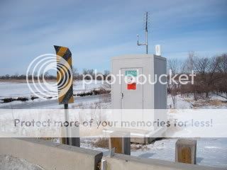
A great website to watch the levels of rivers
and lakes during these events is www.rivergages.com This
website can provide vital information on current levels of water
and helps communities prepare. Iowa is located in the Rock Island
District.
The coordinates will take you to the Beaver
Creek Gage located in Polk County, IA on the left bank, 10ft
upstream from the NW 70th Ave bridge, 0.5 miles downstream of
Little Beaver Creek, 2.5 miles east of Grimes, 6miles above the
mouth of the Beaver Creek. This particular gage is considered to be
in the Des Moines River Basin. Flood stage for this Beaver Creek
Gage is 12.0ft. The highest level recorded at this gage was during
the Great Flood of 1993. This gage reached 16.58ft on July 10,
1993.
LOCAL GEOLOGY: The area surrounding
the Beaver Creek is mostly farm land. This area floods very easily
because of the topography. This site is approximately 826 ft
elevation. The river itself has very small banking therefore once
the water comes out of is banks the flooding begins to the
immediate East. The elevation begins to drop and thus causing the
fields and roads to begin to flood. The area immediately to the
west and the next 2 miles of the river the elevation to the west
rises over 100ft. This causes a ramping effect of the river to go
into the low lying fields.
In times of heavy flooding these gaging
stations along the creeks and rivers surrounding the city are vital
in the early warning of potential flooding of low lying areas along
the Beaver Creek and the other rivers of Polk County and further
downstream
To get credit for this cache you must do the
following:
1. Post a picture with your log on the south
bridge with your GPS
EMAIL THE FOLLOWING ANSWERS TO ME, DO NOT
POST IN YOUR LOG:
2. While on the bridge calculate the current
width of the creek. You can do this by making a way point at one
edge of the creek and walking across the bike path until you get to
the next edge of creek.
3. Remembering the website I mentioned and
the District and Basin this gage is located. What is the current
depth stage of this gage while you were doing this
Earthcache?
4. Remembering the website I mentioned and
the District and Basin this gage is located. During the 500-Year
Floods of 2008, the highest recorded level was almost broken. How
high (in hundredths) and what day in 2008 was the peak of this
Beaver Creek Gage?

If you enjoyed this Earthcache, please
give it a favorite point...thanks