IATCC Mishigami
Type of Land:
Wisconsin State Forest - Point Beach State Forest.
Open 24 hours per day, 365 days per year. Pets are allowed on leash. No bicycles, snowmobiles, or other vehicles. Hunting is allowed in Wisconsin State Forests
Terrain:
Fairly easy with small hills
Beach area would make it difficult for most wheelchairs or strollers.
Description of Area:
Trailhead is at south end of park boundary. Parking and walking into the park at this point does not require an entrance fee. Drive north on Park Road in Two Rivers, WI to cul-de-sac. Parking area is at a cul-de-sac in a residential area. Please do not block driveways or park in front of fire hydrant. Take the wooded trail to the sandy beach.
Suggested Equipment and Supplies:
Warm weather - water sandals / Cold weather - waterproof boots that are at least knee high.
· Tape measure or other method of measuring distance.
· Thermometer (recommend range of at least 0° - 100°); a candy thermometer works well.
· GPS Unit
GPS Coordinates:
Parking - N44 09.448' W087 32.731'
Site Point A - N 44 09.438' W087 32.552'
Site Point B - N 44 09.590' W087 32.337'
Site Point C - N 44 09.635' W087 32.354'
Educational Information:
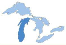
Mishigami, the Ojibwa or Algonquian Indian word for "great water," is believed to be the origin of the current name for Lake Michigan. Lake Michigan is the third-largest of the five great lakes of North America and the only one located entirely within the United States of America.
The drainage basin, approximately twice as large as the 22,400 square miles of surface water, includes portions of the surrounding states of Wisconsin, Michigan, Indiana, and Illinois.
Lake Michigan is approximately 307 miles long by 118 miles wide with a shoreline of 1640 miles. It has the largest surface area of any lake that is entirely within one country, and is the fifth largest lake in the world by surface area. The lake's average depth is 279 feet, while its greatest depth is 923 feet, for a total volume of 1,180 cubic miles of water. Because Lake Michigan is joined to Lake Huron at the Straits of Mackinac, they are considered one "hydraulic" lake. The surface level of both lakes averages 577 feet above sea level.
The primary outlet is through the Straits of Mackinac to Lake Huron. The Saint Lawrence Seaway links it with the Atlantic Ocean. A civil engineering feat in 1900 changed the flow of the Chicago River from entering into Lake Michigan for sanitation reasons. There is now a diversion from Lake Michigan into the Mississippi River basin through the Chicago River.
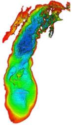
The Milwaukee Reef runs from Milwaukee, Wisconsin to a point between Grand Haven and Muskegon, Michigan. This natural underwater feature divides the lake into northern and southern pools that each have a counterclockwise flow of water. The flow of water derives from rivers, winds, and the Coriolis Effect, which is a physics term for a deflection of moving objects from a rotating reference frame. Internal waves (up welling) can produce a 15 degree Celsius water temperature decrease along the coast in only a few hours.
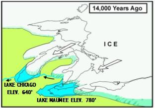
Lake Michigan is believed to be a large glacier feature that was scourged during the last Great Ice Age. The advance of the Wisconsin glacier progressed in several major lobes through the region. These lobes were mostly caused by outcrops of highly resistant bedrock. The surface rocks were relatively soft shales and sandstones which the drainage system cut into creating river valleys. The valleys provided avenues for the ice to follow and the glacier advance widened and deepened the valleys. During the advanced stages and early retreat, the glacier melt water flowed into the Mississippi watershed and down into the Gulf of Mexico. As the glacier retreated into Canada, the great lakes were formed and the primary outlet changed to the Atlantic Ocean through the Saint Lawrence Seaway.
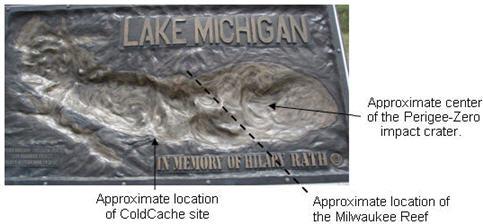
Another recent theory is that the southern pool of Lake Michigan may have also been the site of a shallow Perigee-Zero impact crater created by a meteorite strike into the Wisconsin Ice Sheet.
Lake Michigan's significance to both human and natural ecosystems remains strong despite the fact that it has diminished from its original size over time.
In order to log this EarthCache as a find the following tasks must be completed:
1. At site point A (N 44 09.438' W087 32.552')
· Record air temperature, weather, and lake conditions; (eg: wind, waves, etc)
· Record water temperature at a point that is at least a foot past the low point of the waves; (if frozen; estimate thickness of ice)
· Measure distance from the marker to the high point of the waves
2. At site point B (N 44 09.590' W087 32.337')
· Record water temperature; (if frozen; estimate thickness of ice)
3. At site point C (N 44 09.635' W087 32.354')
· Record water temperature; (if frozen; estimate thickness of ice)
· Explain why the water temperatures may be different at the various locations.
Please email the answers to me via my profile on the cache page.
Side Trip Point of Interest:
Visit a relief map of Lake Michigan at a pull off along Memorial Drive between Two Rivers and Manitowoc (N 44 08.228 W087 35.169).
 IATCC is the cache designation to highlight a series of EarthCaches along the Ice Age National Scenic Trail grouped into a special category called "ColdCache."
The Ice Age Trail is one of eleven National Scenic Trails designated by the National Park Service. This unique trail is entirely within the state of Wisconsin and follows along the terminal moraine of the most recent glacier which retreated about 10,000 years ago.
This project is supported by the Ice Age Trail Alliance (IATA). The goal is to bring more visitors to the trail and promote public awareness, appreciation, and understanding of Wisconsin’s glacial landscape.
The IATA has created an awards program to encourage visits to the trail and ColdCache sites. This awards program is separate from, and in addition to, any other Geo- or EarthCache awards program.
A current list of approved ColdCache sites can be found on the “IATCC Bookmark List”. More information on the Ice Age Trail Atlas, the Companion Guide, the ColdCache Project and Awards Program can be found on the “ColdCache Webpage”
The Geocache Notification Form has been submitted to Guy Willman. Geocaches placed on Wisconsin Department of Natural Resource managed lands require permission by means of a notification form. Please print out a paper copy of the notification form, fill in all required information, then submit it to the land manager. The DNR Notification form and land manager information can be obtained at: http://www.wi-geocaching.com/modules.php?name=Wiki&pagename=Hiding%20A%20Cache