Monte da
Lua
The Earth's surface is the result of a balance
between the planet's internal forces, that create volcanoes,
mountain ranges and depressions and move the rigid chunks of the
crust around (the tectonic plates) and the never ending effects of
the external atmospheric elements and the
river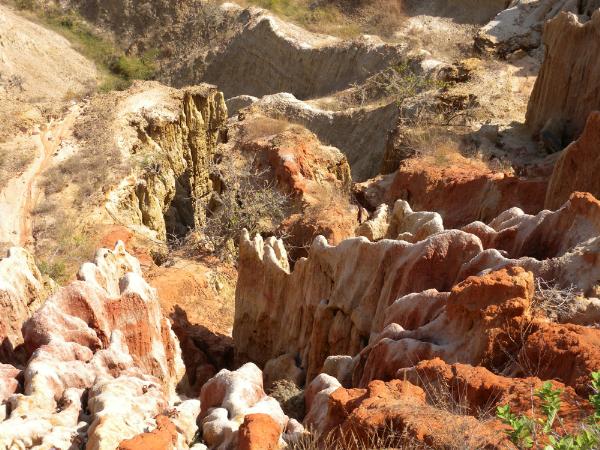 s and oceans (basically air
and water, liquid or solid) . Internal forces create
topographic features, irregularities, and air and water (with
the help of the long geological time) smooth them out. Where
there is a hill, there's material moving to fill a
valley.
s and oceans (basically air
and water, liquid or solid) . Internal forces create
topographic features, irregularities, and air and water (with
the help of the long geological time) smooth them out. Where
there is a hill, there's material moving to fill a
valley.
A gully is a landform created by running water
that sharply erodes the soil, typically on a hillside. Gullies
resemble large ditches or small valleys; their size varies from
meters to tens of meters in depth and width. When the gully is
being formed, it acts as a preferential channel and the water flow
rate can be substantial, reinforcing the erosional potential and
increasing the soil cutting action.
Gullying, or gully erosion, is the process by
which gullies are formed. Hillsides are more prone to gullying when
they are cleared of vegetation, through deforestation, over-grazing
or otherwise. The eroded soil is easily carried array by the
flowing water, normally during short, intense storms. The total
soil loss from gully formation and the consequent downstream river
sedimentation can be sizable. Gullies reduce the productivity of
farmland where they incise into the land and produce sediment that
may clog downstream water bodies. Gullies can affect also whole
localities (e.g. Calonda, in Lunda Norte, Angola), destroying paved
houses, roads and other infrastructures. Because of this, much
effort is invested into the study of gullies within the scope of
geomorphology, namely in what concerns in the prevention of gully
erosion and in the restoration of gullied landscapes.
Gully erosion represents an important sediment
source in river systems and accounts for as much as 70 to 90% of
the overall sediment production of a catchment. In mountain areas,
the steep slopes enhance gully processes, accelerate sediment
transfer from uplands to valley bottoms and generate natural
hazards: mudflows, overflowing of heavily loaded floods, silting up
of reservoirs, for example.
The cache:
The cache will lead
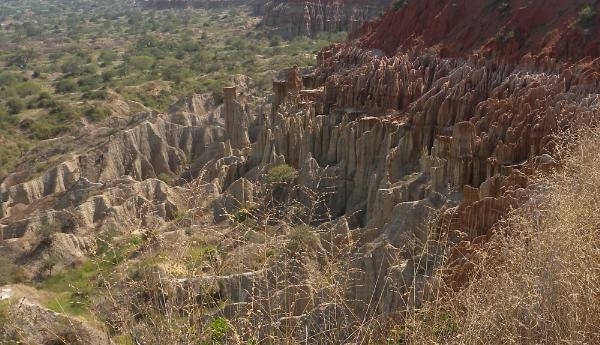
you to a beautifull scenario, Monte da Lua, where the gullying
process is clearly visible (Monte da Lua, Moon Hill, would be a
clearly appropriate designation had not current water been the
cause of the process...). The wide grain size distribution of the
fomrations' sediments (larger stones acting as caps of finer
grains) is in the basis of a scenic bonus, the hoodoos (fairy
chimneys), a by-product of the gullying process.
To claim
the cache, on the PZ facing south, you have to answer this
questions:
-
How many
beds can you see?
-
What is
the thickness of the first bed (top)?
-
What is
the color and texture of the first bed?
-
Take a
picture of you with MrGPS, where we can also see the
gullying.
Mail me
the answers, and after permission, make your log and upload your
picture.
A cache:
Esta cache leva-o a um magnífico miradouro
denominado Monte da Lua. Aqui podem ser observados os efeitos sobre
a topografia do fenómeno "ravinamento".
Para
reclamar esta cache, coloque-se no PZ, observe a ravina a Sul e
responda às seguintes questões:
-
Quantas camadas
distintas compõem a
ravina?
-
Qual a espessura da
primeira camada?
-
Qual a cor e a
textura da primeira camada?
-
Tire uma fotografia
sua com o MrGPS, onde seja possível visualizar também a
ravina.
Envia-me
as respostas por mail, e após autorização faça o seu log e o upload
da fotografia exigida.
