Eskers: Ancient Glacial Riverbeds EarthCache
Eskers: Ancient Glacial Riverbeds
-
Difficulty:
-

-
Terrain:
-

Size:  (not chosen)
Please note Use of geocaching.com services is subject to the terms and conditions
in our disclaimer.
This is an Earthcache. There is no container hidden for this type of geocache. Instead, it is an educational cache in which you answer questions about a geologic feature at the listed coordinates to get credit for the cache.
Earthcache Requirements:
This Earthcache is located along the scenic Ice Age Trail. Permission has been granted by Eric Sherman of the Ice Age Trail Alliance. Park at the Ice Age Trailhead off Paradise Drive at N43º 23.902, W088º 12.650. Follow the YELLOW markers and PLEASE STAY ON THE TRAIL!
Email the following to owner:
1. At the posted coordinates, look closely at the landscape. Find the esker. What is the directional orientation of the esker?
2. Estimate the height and width of the esker in front of you.
3. Are eskers formed during a glacial advance or a glacial retreat?
4. Both moraines and eskers are ridges of sediment and debris. How do they differ?
Eskers: Ancient Glacial Riverbeds
Look around where you’re standing or sitting right now. If you were in Wisconsin just 15,000 years ago, you would be encased in a colossal sheet of ice called a glacier!
What is a Glacier?
Glaciers are multiple layers of fallen snow, compressed into ice over hundreds of years. Glaciers form during an extended cold period when snow remains in the same area year-round, with additional snow accumulating on top of the existing snow. Each new layer of snow buries and compresses the previous layers. This compression forces the snow to re-crystallize. Gradually, these crystallized grains grow larger and the air pockets between the grains get smaller, causing the snow to slowly compact and increase in density. After about two winters, the snow turns into firn -- an intermediate state between snow and glacier ice. Years of compression gradually make the ice denser over time, forcing out the tiny air pockets between crystals until it becomes a solid sheet of ice.
Glaciers On the Move
A unique feature of glaciers is their ability to move, mostly from sheer mass, like a slow-moving river away from the polar caps. When the climate is cold, the glaciers advance. These periods are often called “Ice Ages.” During warmer temperatures, they start to melt and retreat.
These temperature flucuations have occurred frequently over the past 2 million years, a time known as the Pleistocene Epoch. Many times, the glaciers spread from the Arctic, engulfing most of northern North America. The most recent series of glacial advances and retreats was called the Wisconsin Glaciation, lasting from about 100,000 to 10,000 years ago. It last flowed into Wisconsin about 25,000 years ago, and by 14,000-16,000 years ago, advanced to cover about 2/3 of the state before melting back.
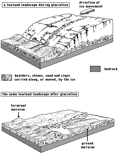
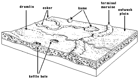
As the glacial ice advanced, it froze around grains of sand, pebbles, and even large boulders, picking them up and carrying them along. Large boulders that were moved a long distance are called erratics. When these rocks and boulders were at the bottom of the moving glacier, they sometimes scraped across the land, making scratches and striations in the bedrock. In some places, they formed elongated hills called drumlins. You can see the direction the ice flowed from the direction and striations of the drumlins. Drumlins are are aligned parallel to the ice flow.
When the ice melted during a glacial retreat, all the sand, silt, pebbles, and boulders that were previously trapped in the ice were dropped or carried to the outer edge of the retreating glacier. This mound of debris formed ridges called moraines. These ridges vary in different parts of the state, but some areas have moraines as high as 300 feet. Sometimes, when the flow of melting stopped during a cooler period, a block of ice would get separated from the glacier and get buried among the debris. When this block of ice finally melted during a warmer period, a basin or depression would be left in its place. These depressions are called kettles. Many of Wisconsin’s lakes, bogs, and marshes are actually Ice Age kettles that filled with water when the ice melted.
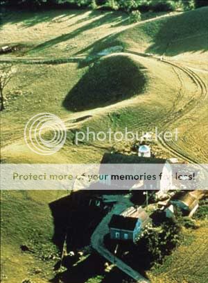
As the ice melted, the flowing meltwater also shaped much of the landscape. Streams flowing over, under, and beyond the glacier left behind deposits of sand and rock debris. Conical water-rounded mounds of debris deposited by streams flowing downward through cracks in the ice are called kames. Narrow, steep-sided ridges formed from deposits of sand and gravel as the river flowed through tunnels at the base of the glacier are called eskers.
All About Eskers
The word Esker is derived from the old Irish Gaelic eiscir, meaning “ridge of gravel.” Eskers are formed from meltwater flowing in channels along zones of weakness at the base of glaciers. Melting ice, water, and debris that are trapped in the ice from the last glacial advance (such as rocks, gravel, and sand) fall through cracks in the glacier until they reach the bottom. The trapped water builds up, forming pools. Eventually, the water breaks through ice at the base, flowing out as a stream, carrying the debris with it. Esker rivers prefer to erode the overlying ice rather than bedrock. As the stream flows, the debris is deposited along the riverbed. After many years, the debris in the riverbed accumulates upward, forming a ridge in the shape of the stream. Sometimes the streams are very curvy, depending on their path beneath the glacier. When the glacier finally melts, a snakelike hill remains.
The esker deposits range from cobbles and boulders in high flow-rate areas to fine sand or silt in areas of low discharge. The slower the stream, the greater the chance for a deposit. Because of this, many eskers are not continuous, but a series of ridges, because the sediment was only deposited in places where the meltwater slowed down. Like drumlins, eskers are usually parallel to the ice flow.
Eskers have some unique features. Since the meltwater was confined by the surrounding ice, the river sediments were deposited above the surrounding terrain, and in some cases, the river even flowed uphill. Subglacial esker rivers are not only driven by gravity like regular rivers, but also by the hydrostatic pressure of the overlying ice.
Eskers come in many shapes and sizes. They can be straight or curvy. Some are only a few feet high, while others are as high as 250 feet. Their length can range from a tenth of a mile to tens of miles, and their width varies from a few feet to over 400 feet wide. They might be broad and flat topped, or have single or multiple crests. Many eskers, like other glacial formations, have been modified and reduced by erosion over time, but the Kettle Moraine region still has many impressive examples of these remnants from the end of the last Ice Age.
Eskers have provided some practical applications in recent history. Because they are mostly made of highly porous sand and gravel and are well-drained, they have been used since prehistoric times as a natural elevated roadway. Many civilizations have used them as sites for graveyards. And eskers are frequently quarried for construction materials.
Sources:
1. University of Wisconsin: http://www.uwex.edu/wgnhs/iceage.htm
2. National Snow and Ice Data Center: http://www-nsidc.colorado.edu/index.html
3. The National Park Service: http://www.nps.gov/archive/iatr/expanded/history.htm
Additional Hints
(No hints available.)