Vulkankrater Gebirgsstein EarthCache
Vulkankrater Gebirgsstein
-
Difficulty:
-

-
Terrain:
-

Size:  (not chosen)
Please note Use of geocaching.com services is subject to the terms and conditions
in our disclaimer.
In der Zeit des Tertiär fanden innerhalb der Erdkruste bedeutende
Bewegungen statt. Dort wo an tiefen Brüchen vor etwa 10 bis 30
Millionen Jahren Magma aus dem Erdmantel bis an die Erdoberfläche
steigen konnte, entstanden ausgedehnte Vulkangebiete wie zum
Beispiel hier in der Rhön. Normalerweise sind diese Vulkane heute
so weit erodiert, dass ihre Kraterform nicht mehr zu erkennen
ist.
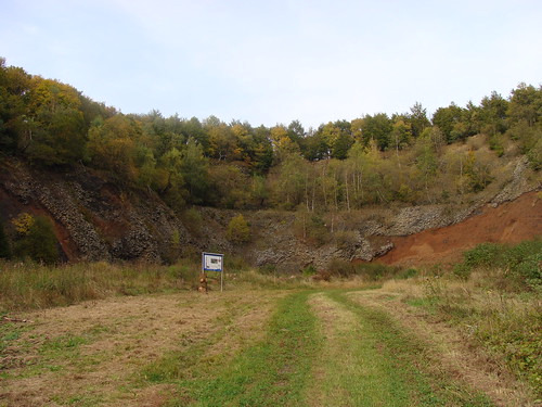
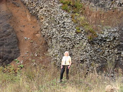
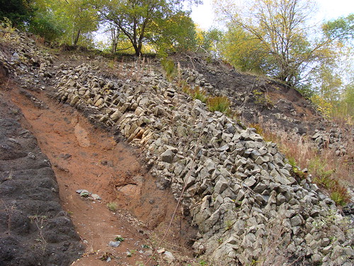
Im Steinbruch Gebirgsstein wurde durch den Abbau von Basalt (1937
bis 1962) jedoch die Struktur eines ehemaligen Vulkankraters wieder
sichtbar und zeigt in einzigartiger Weise einen Querschnitt durch
den Schlackenkegel mit dem darin liegenden Lavasee. Der im Zentrum
des Kraters angelegte Steinbruch erschließt 2 unterschiedliche
Gesteine vulkanischen Ursprungs (Schlacke und schwarzer Basalt),
die bei verschiedenen Ausbruchsphasen entstanden sind. Genauere
Details stehen auf der Infotafel die man an den oben angegebenen
Koordinaten findet.
Logbedingungen:
1) Schicke mir die Antworten auf folgende 2 Fragen über mein Profil
zu:
a) Schlacke ist das Produkt welcher Phase des Vulkanismus?
b) Wie ist der schwarze Basalt entstanden?
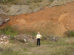
2) Stelle mit Deinem Log ein Foto von Dir und Deinem GPS-Gerät ein,
bei dem man im Hintergrund den Vulkankrater sieht.
Interessante Links:
Vulkankrater
Vulkan
Lava
Basalt
Vulkankrater Gebirgsstein (Anfahrtsbeschreibung)
P.S.: Für den Erstfinder gibt es wie immer eine noch nicht
aktivierte Geocoin zusammen mit dem Aktivierungscode. Diesmal passt
sie jedoch nicht in den Cache und kann daher nur per Post
zugestellt werden.
English:
At the time of the tertiary period significant movements were
within the crust. Approximately 10 to 30 million years ago at deep
fractures magma rose from the mantle up to the earth’s surface,
which caused expanse volcanic regions such as here in the Rhön
Mountains. Normally these volcanos are now eroded to such an extent
that the crater form is no longer visible.
Through the digging of basalt (from 1937 to 1962) in the stone
quarry Gebirgsstein the structure of an old volcanic crater is
visible again in a unique way and shows a profile of the cinder
cone with a lava lake. The stone quarry in the center of the crater
opens up 2 different volcanic rocks (scoria and basalt) that have
arisen at various stages of the eruption. More precise details are
available on the information board at the coordinates given above.
If you want to log this earthcache:
1) Send me the answers of the following 2 questions through my
profile:
a) Scoria is a product of which stage of volcanism?
b) How did the black basalt come into existence?
2) Please log with a photograph of your group and your GPS in front
of the volcanic crater.
Interesting Links:
Volcanic
crater
Volcano
Lava
Basalt
Vulkankrater Gebirgsstein
Additional Hints
(No hints available.)