Trockental Falkenstein
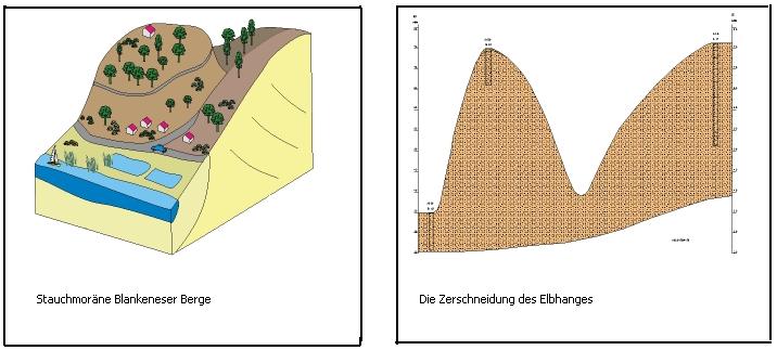
Die Blankeneser Berge weisen eine Gesamtlänge von ca. 5km auf und zählen neben den Harburger Bergen zu den höchsten Erhebungen Hamburgs.
Und jeder, der dort schon einmal spazieren gegangen ist oder mit dem Fahrrad unterwegs war, weiß, dass dort teilweise Gefälle bzw. Anstiege von bis zu 16% zu bewältigen sind.
Wie allerdings dieser durch mehrere Täler durchschnittene Höhenzug entstanden ist, ist oftmals unbekannt.
Daher lädt euch dieser Earthcache ein, mehr über dieses Gebiet und insbesondere über das Falkensteiner Trockental zu erfahren, das als ein besonders gut erhaltenes Beispiel für Trockentäler gilt.
Ein kleiner Rundgang, auf dem ihr ca. 60 Höhenmeter überwinden müsst, verschafft euch einen ersten Eindruck vom Gelände und dessen Entstehung im Laufe der letzten Eiszeit, der Mittleren Saale-Kaltzeit.
Start ist bei N 53.33.997, E009.46.768. Dieser Punkt ist mit öffentlichen Verkehrsmitteln zu erreichen, und hier könnt ihr auch Parken.
Folgt nun dem Weg Richtung N 53.33.735, E 009.46.784 bis hinunter zur Elbe.
Unten angekommen, trefft ihr auf ein Straßenschild: haltet euch rechts und folgt dem Falkensteiner _ _ _ _",
(gesuchte Buchstaben: 2.=D, 3.=E)
bis ihr in gut 200m auf die Straße "Falken_ _ _ _ _ _ _ _ trefft.
(gesuchte Buchstaben: 3.=A, 8.=B)
Nun geht es wieder aufwärts: biegt nach rechts in diese Straße ein und folgt ihr solange, bis ihr auf den "_ _ _ _ _ _weg" trefft.
(gesuchte Buchstaben: 2.=F, 6.=C)
(Die Buchstaben entsprechen ihrer jeweiligen Position im Alphabet.)
Jetzt ist es nicht mehr weit bis zu dem Punkt, der u.a. als Logbedingung gilt und von dem ihr einen herrlichen Ausblick auf die Umgebung und die Elbe habt:
N 53.33.A(B:5)(C:2), E 009.46.D(E-1)F
Wenn ihr oben seid, setzt euch erst einmal und genießt die Aussicht!
Auf eurem Rundweg durch das Falkensteiner Trockental trefft ihr auf diese 2 Findlinge aus der Eiszeit, an denen ihr eine kleine Aufgabe lösen müsst, um diesen Cache zu loggen (s. Logbedingungen):
(Wichtig: Nehmt eine Schnur oder ein Metermaß mit auf diesen Cache!)

Logbedingungen:
Mailt mir die Antworten auf folgende Fragen - ich freue mich ebenfalls sehr über ein Foto von euch und/oder eurem GPS an dem Baum der "Final"koordinaten (optional, keine Logbedingung).
1. Warum spricht man hier von einem Trockental? Nenne einen der Prozesse, der zur Bildung dieser Täler führt.
2. Durch welchen Vorgang kam es zur Zerschneidung des Elbhanges, und aus welchen Materialien bestehen die Blankeneser Berge hauptsächlich?
3. Welche Länge (in cm) weist der größere (rechte) der beiden Findlinge auf?
Ich wünsche euch viel Spaß beim Erkunden des Falkensteiner Trockentals!
Du darfst diesen Earthcache mit Beantwortung der Fragen per eMail gleich loggen. Sollten Deine Antworten falsch sein, melde ich mich.
------------------------------------------------------------
English Version:
The Dry Valley of Falkenstein
The "Blankeneser mountains" have a total length of about 5 km and are in addition to the "Harburger mountains" the highest elevations of Hamburg.
And everyone who has gone there once before walking or cycling knows, that there are gradient increases of up to 16%.
However, the origin or development of this area is often unknown.
This Earth Cache invites you to learn more about this area and in particular on the "Falkensteiner Dry Valley", which is considered a particularly well-preserved example of dry valleys.
On this small tour through the valley where you have to surmount about 60 meters, you get a first impression of the terrain and its origin in the course of the last Ice Age, the Middle Saale-glaciation.
Start is at N 53.33.997, E009.46.768.
This point can be reached by public transport, and here you can also park your car.
Now follow the path towards N 53.33.735, E 009.46.784 down to the river Elbe.
Reached the bottom, you hit a street sign, you keep right and follow the
Falkensteiner _ _ _ _
(sought letters: 2.=D, 3.=E)
approximately 200 meters where you will meet on the street
Falken_ _ _ _ _ _ _ _
(sought letters: 3.=A, 8.=B)
Now it's back up: turn right into this street and follow her until to the
_ _ _ _ _ _weg.
(sought letters: 2.=F, 6.=E)
(The letters correspond to their respective position in the alphabet.)
Now it's not far to the final point that is condition for to log this cache and from which you have a wonderful view of the surroundings and the river Elbe:
N 53.33.A(B:5)(C:2), E 009.46.D(E-1)F
If you reached the top, sit down once and enjoy the view!
On your way through the valley you pass by two conspicuous glacial stones (see photo above). Here you have to solve a small task (see log conditions).
Important: Take a cord or tape measure wirh you on this cache!
Log conditions:
Mail to me the answers to the following questions - I would be very happy if you take a picture of you and/or your GPS at the tree of the final coordinates (optional, not a log condition):
1. Why this is called a dry valley? Designate one of the processes leading to the formation of these valleys.
2. By what process it came to the fragmentation of the "Elbhang", and of what material the "Blankeneser Mountains" consist mainly?
3. What is the lenght of the more bigger of the two glacial stones (the right of the two) in cm?
I wish you much fun exploring the Falkensteiner Dry Valley!
You can log this earthcache immediately by answering the questions via email. Should your answers be wrong, I will contact you.