Fox Locks #3 | Chasing the Fox Mystery Cache
Fox Locks #3 | Chasing the Fox
-
Difficulty:
-

-
Terrain:
-

Size:  (small)
Please note Use of geocaching.com services is subject to the terms and conditions
in our disclaimer.

Part of the newly revised Fox Locks
series, this set of caches is intended to bring about an awareness
and appreciation for the For River Lock system, highlighting all 17
locks from Menasha to Kauakuna. These 17 locks, now incorporated
and controlled under that auspices of the The Fox River
Navigational System Authority (FRNSA), once again allow navigation
downriver from Lake Winnebago to Green Bay. The ability to traverse
these waters has not possible since the locks closed in
1982.
Fox Locks caches would not be complete without a little
history:
Great Lakes-Mississippi Water Link
Sought*
On a mission for Samuel de Champlain, the governor of New
France, Jean Nicolet was charged with finding a route from the
Great Lakes to the Mississippi River. In 1634 he arrived at La Baye
des Puans, where the Fox River empties into Lake Michigan, and
claimed the region for France. But La Baye did not gain importance
until 16DB when Jesuit missionary
Father Claude Allouez, who established a mission there, traveled
the length of the Fox River and discovered a waterway to the
Mississippi River, indirectly linking the St. Lawrence and the Gulf
of Mexico.
La Baye became a fur-trading center and its future importance was
secured when Nicolas Perrot was made commandant of La Baye. Perrot
was an effective diplomat who made alliances and trade agreements
with Native Americans. The lands of the upper Mississippi became
the possession of the French Empire when a formal agreement was
signed at Fort St. Antoine in 1689, turning a lucrative fur trading
region over to the French. But when Perrot was recalled to France
in 17FD, his diplomatic policy was
replaced by a military regime. The resulting tensions developed
into warfare with the Fox Indians that continued until 1740, when
fur trading again prospered and permanent housing was
constructed.
In 1745 Augustin de Langlade established a trading center on the
bank of the Fox River; his relations with Native Americans were
built on trust and respect. Langlade's large family controlled the
region's trade, owned large parcels of land, married Menominee
tribe women, and lived independent of French rule. During the
French and Indian War, the Langlades left La Baye to fight against
the British in Ohio and Canada. The British gained control of what
was known as the Northwest Territory and captured Fort La Baye,
which they rebuilt and renamed Fort Edward August. The British also
renamed the area Green Bay, after the green-tinted streaks that
stripe the bay in springtime. Trade flourished for both French and
English settlers during the period of British rule and continued to
prosper after the Northwest Territory was transferred to the U.S.
government after the Revolutionary War.
As I develop this series and expand upon it I discover new things,
including the recent revelation that this navigable waterway once
extended far beyond the confines of the Fox River Valley, indeed
stretching all the way to the Mississippi River as a navigable
waterway.

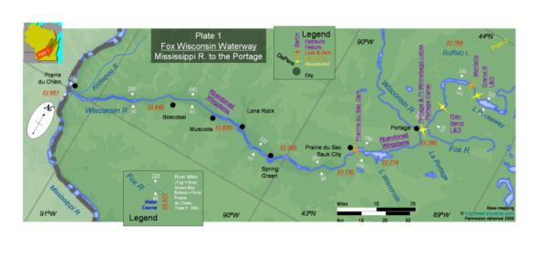

As well as pulling a couple numbers from the signage at the posted
cords, you will also need to reference the flowage profile and
waterway plates to get your answers. According to the signage, the
rapids that were once here descended 1C0 feet over the course of 3B miles between Winnebago and Green Bay. At
the mouth of Green Bay the water level is 577 feet with the most
dramatic drop in elevation occurring between Appleton and Kaukauna.
In fact, there are only A locks
whose upper fill level is below 600'. Studying the profile and the
traverse plates reveal a lot about the system and it's state of
repair as it was when these plates were assembled. Much of the
middle section of the navigable waterway is marked as being
not-so-navigable. Besides the series of closed wingdams in the
western part of the state, the Longitudinal Profile depicts
E combined Dam and Lock locations
with abandoned locks as well as F
dam only locations marked closed.
Final Cords are N44°15.ABC
W88°23.DEF
Remember this friends, you will be quizzed on it later....
*University of Wisconsin-Green Bay-Area Research Center, 2420
Nicolet Drive, Green Bay, WI 54311-7001; telephone
(920)465-2539
Additional Hints
(No hints available.)