The name of the mountain evolved from a 1652 rendering of the
indigenous name for the mountain, Carasarga, which it is surmised
means "notch-pointed- mountain of pines."
Kearsarge is a monadnock (a small mountain that rises abruptly from
a gently sloping or virtually level surrounding plain), and
although of only moderate elevation, its isolation gives it 2,100
ft of relative height above the low ground separating it from the
higher mountains farther north. That makes Kearsarge one of twelve
mountains in New Hampshire with a prominence over 2,000 ft. On a
very clear day, skyscrapers in the city of Boston, Massachusetts 80
miles away are visible from the fire tower on the summit.
Below we will learn about the last glacier that came through
this area and about evidence of it that still exists.
Brief Glacial
History
The last glacial period is sometimes colloquially referred to as
the "last ice age", though this use is incorrect because an ice age
is a longer period of cold temperature in which ice sheets cover
large parts of the Earth, such as Antarctica. Glacials, on the
other hand, refer to colder phases within an ice age that separate
interglacials. Thus, the end of the last glacial period is not the
end of the last ice age. The end of the last glacial period was
about 12,500 years ago, while the end of the last ice age may not
yet have come:little evidence points to a stop of the
glacial-interglacial cycle of the last million years.
The glaciations that occurred during this glacial period covered
many areas, mainly on the Northern Hemisphere and to a lesser
extent on the Southern Hemisphere. In its entirety, the ice sheet
that covered much of the Northern part of the North American
continent was known as the Laurentide ice sheet. The glaciation
that covered New England is known as the Wisconsinan or Wisconsin
glacial episode. This glaciation is made of three glacial maxima
(sometimes mistakenly called ice ages) separated by interglacial
warm periods (such as the one we are living in). These glacial
maxima are called, from oldest to youngest, Tahoe, Tenaya and
Tioga. The Tahoe reached its maximum extent perhaps about 70,000
years ago, perhaps as a byproduct of the Toba super eruption.
Little is known about the Tenaya. The Tioga was the least severe
and last of the Wisconsin Episode. It began about 30,000 years ago,
reached its greatest advance 21,000 years ago, and ended about
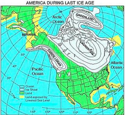
10,000 years ago. At the height of glaciation the Bering land
bridge permitted migration of mammals such as humans to North
America from Siberia. At its maximum extent, global sea level was
about 390 feet lower than today’s level and the continental
shelf south of Cape Cod was exposed as a coastal plain!
Evidence of
Glacial Advance
Glacial landforms are those created by the action of glaciers.
Most of todays glacial landforms were created by the movement of
large ice sheets during the Quaternary glaciations. The three most
common classifications of landforms are:
Erosional
landforms
As the glaciers expanded, due to their accumulating weight of snow
and ice , they crushed and scoured surface rocks and bedrock. Rocks
and sediments are added to glaciers through various
processes.
Glaciers erode the terrain principally through two methods:
abrasion and plucking.
As the glacier flows over the bedrock's fractured surface, it
softens and lifts blocks of rock that are brought into the ice.
This process is known as plucking, and it is produced when
subglacial water penetrates the fractures and the subsequent
freezing expansion separates them from the bedrock. When the ice
expands, it acts as a lever that loosens the rock by lifting it.
This way, sediments of all sizes become part of the glacier's load.
The rocks frozen into the bottom of the ice then act like grit in
sandpaper.
Abrasion occurs when the ice and the load of rock fragments
slide over the bedrock and function as sandpaper that smoothes and
polishes the surface situated below. Visible characteristics of
glacial abrasion are glacial striations. These are produced when
the bottom's ice contains large chunks of rock that mark scratches
in the bedrock. By mapping the direction of the flutes, researchers
can determine the direction of the glacier's movement. Chatter
marks are seen as lines of roughly crescent-shape depressions in
the rock underlying a glacier, caused by the abrasion where a
boulder in the ice catches and is then released repetitively as the
glacier drags it over the underlying basal rock.

Depositional
landforms
Later, when the glaciers retreated leaving behind their freight of
crushed rock and sand (glacial drift), they created characteristic
depositional landforms. Examples include glacial moraines, eskers,
and kames. Drumlins and ribbed moraines are also landforms left
behind by retreating glaciers. The stone walls of New England
contain many glacial erratics, rocks that were dragged by a glacier
many miles from their bedrock origin.
Glacial lakes and
ponds.
Lakes and ponds can also be caused by glacial movement. Kettle
lakes form when a retreating glacier leaves behind an underground
or surface chunk of ice that later melts to form a depression
containing water. Moraine-dammed lakes occur when a stream (or snow
runoff) is dammed by glacial debris.
Mount Kearsarge has at its summit some good examples of the
glacial abrasion process noted above as striations. Glacial
striations on the trail and at the summit occur as multiple
straight, parallel grooves representing the movement of the
sediment-loaded base of the glacier. Large amounts of coarse gravel
and boulders carried along underneath the glacier provided the
abrasive power to cut the grooves, and finer sediments also in the
base of the moving glacier further scoured and polished the
bedrock. Look at the examples of striations below.


References:
Wikipedia
Laurentide Glaciation of the Massachusetts Coast, by Margaret
Martin
LOGGING
REQUIREMENTS
The cache coordinates will bring you to a glacial striation.
Email to me the answers to the following questions and post with
your log a picture of this striation with your GPSr in the picture.
(do not show the question #2 object)
Question #1: What is the compass direction of the
striation?
Question #2: Describe the object in the middle of the
striation?
Question #3: There are other striations close by. Describe their
direction.
While at the summit, wander about. There are striations of all
sizes all over the bare rock. Also, there is a chiseled town line
marker for the towns of Wilmot & Warner. See if you can find
it. If you take the red trail from the Winslow State Park side,
there are some good examples of striations right on the trail.