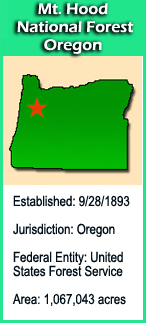
Located twenty miles east of the city of Portland, Oregon, and the northern Willamette River valley, the Mt. Hood National Forest extends south from the strikingly beautiful Columbia River Gorge across more than sixty miles of forested mountains, lakes and streams to Olallie Scenic Area, a high lake basin under the slopes of Mt. Jefferson. The Forest encompasses some 1,067,043 acres.
Our many visitors enjoy fishing, camping, boating and hiking in the summer, hunting in the fall, and skiing and other snow sports in the winter. Berry-picking and mushroom collection are popular, and for many area residents, a trip in December to cut the family's Christmas tree is a long standing tradition.
The Cascade Range Forest Reserve was established in 1893, and divided into several National Forests in 1908, when the northern portion was merged with the Bull Run Reserve (city watershed) and named Oregon National Forest. The name was changed again to Mt. Hood National Forest in 1924.
Some popular destinations that offer rewarding visits are Timberline Lodge, built in 1937 high on Mt. Hood, Lost Lake, Trillium Lake, Timothy Lake, Rock Creek Reservoir and portions of the Old Oregon Trail, including Barlow Road.
There are 189,200 acres of designated wilderness on the Forest. The largest is the Mt. Hood Wilderness, which includes the mountain's peak and upper slopes. Others are Badger Creek, Salmon-Huckleberry, Hatfield, and Bull-of-the-Woods. Olallie Scenic Area is a lightly-roaded lake basin that provides a primitive recreational experience.
 The Geocache Notification Form has been submitted to The Glacial Drumlin Trail office in Lake Mills, of the Wisconsin DNR. Geocaches placed on Wisconsin Department of Natural Resource managed lands require permission by means of a notification form. Please print out a paper copy of the notification form, fill in all required information, then submit it to the land manager. The DNR Notification form and land manager information can be obtained at: http://www.wi-geocaching.com/hiding