This earthcache will take you to three locations. One is an artesian well and the other three are locations that you can draw insight into the how porous (pervious) or impervious local rock formations are.
Definitions
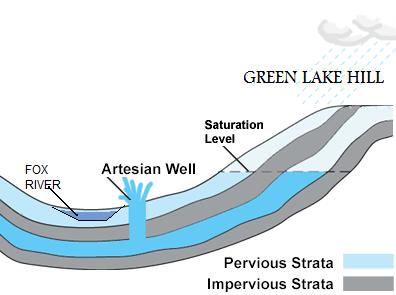
Artesian Well:An artesian aquifer is a confined aquifer containing groundwater that will flow upwards out of a well without the need for pumping.
Grain Size: The grain size of soil particles and the structures they form determine the ability of a soil to transport or retain water. The larger the size of the particles, the more porous the soil is and the easier it is for water is to enter or be transported through it.
Pascal's lawPascal's law predicts the theoretical hydrostatic pressure P: 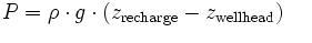
where p (rho) is the density of the fluid, g the acceleration due to gravity, and z is the elevation. In practical terms the pressure is expressed as feet of water column (zr - zw).
"Fossil water" aquifers can also be artesian if they are under sufficient pressure from the surrounding rocks. This is similar to how many newly tapped oil wells are pressurized.
In recharging aquifers, water flows from the well because the water table at its recharge zone is at a higher elevation than the head of the well.
 Source: http://en.wikipedia.org/wiki/Artesian_aquifer
Based on a report written by the Chief Wisconsin Geology in the 1800's their are seven leading conditions to have an artesian well:
1st. There must be a stratum sufficiently porous to permit a ready entrance and flow of water through it. In Wisconsin, this is either limestone or sandstone.
2d. There must be an impervious bed below to prevent escape of water downward.
3d. There must be a like impervious bed above to prevent escape upward, for the water, being under pressure from the head, would otherwise find relief in that direction.
4th. All these beds must form a basin, or at least be inclined, so that the edge at which the waters enter will be higher than the surface at the well.
5th. The edge of the porous stratum must be suitably exposed so as to take in a sufficient quantity of water to afford an adequate supply.
6th. To furnish this supply, there must be an adequate rainfall.
7th. There must be no escape for the water at a lower level than the surface of the well.
source: (Wisconsin. Chief Geologist / Geology of Wisconsin. Survey of 1873-1879 ... Volume I (1883))
To log this geocache you will need the following:
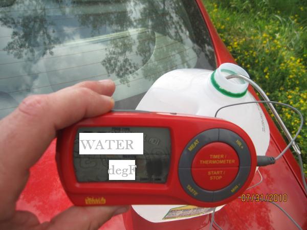
1: A one gallon jug : 
2: A watch :
3: A thermometer: 
You will need to e-mail me the answers to the following questions in your log:
A: What is the temperature of the water?
B: What is the flow rate of the well in gallons/min Example: It takes 15 seconds to fill the one gallon container. There are 60 seconds in a minute so by performing simple math it is determined that the output of the well is 4 gallons per minute.
C. After you have examined the rock layers at each location, e-mail me a description of the grain size or how well the water could flow through that type of rock/soil.
Finally,
D: (OPTIONAL) Please post a picture of you or your thermometer at the well.