The river
Nile and his cataracts…
The River
Nile, the worlds longest river, is a major north-flowing river in
Africa. The Nile has two major tributaries, the White Nile and Blue
Nile, the latter being the source of most of the Nile's water and
fertile soil, but the former being the longer of the two. The White
Nile rises in the Great Lakes region of central Africa to southern
Sudan, while the Blue Nile starts at Lake Tana and flowing into
Sudan from the southeast. The two rivers meet in the Sudanese
capital Khartoum. The northern section of the river flows almost
entirely through desert, from Sudan into Egypt, a country whose
civilization has depended on the river since ancient times. Most of
the population of Egypt and all of its cities, with the exception
of those near the coast, lie along those parts of the Nile valley
north of Aswan; and nearly all the cultural and historical sites of
Ancient Egypt are found along the banks of the river. The Nile ends
in a large delta that empties into the Mediterranean Sea.
In total he
overcame 2.700 m on his journey in the descent. Near Khartum, 2.700
km before the mouth the height sea level is only another 382 m,
that is the river Nile would have to flow actually quite leisurely
and it would have to be well navigable - however, this is not like
this !
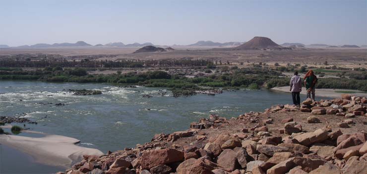
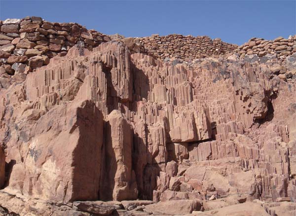
The cataracts
of the Nile are shallow stretches between Aswan and Khartoum where
the water's surface is broken by numerous small boulders and stones
lying on the river bed, as well as many small rocky islets. In some
places, these stretches are punctuated by whitewater and are
perhaps well characterized as rapids, while in others the water
flow is smoother. The six primary cataracts of the Nile were the
main obstacles for boats sailing on the Nile in antiquity. Counted
upstream (from north to south), the First Cataract is in Aswan
(Egypt) - the rest are in Sudan.
Look on the 3rd Cataract ...
The word
cataract is, literally "down-rushing", meaning "waterfall" or
"floodgate". However, none of the Nile's six primary cataracts
would be accurately described as waterfalls, and given the broader
definition, many minor cataracts should perhaps also be included in
the count. Geologists indicate that the region of the northern
Sudan is tectonically active and this activity has caused the river
to take on "youthful" characteristics. The Nubian Swell has
diverted the river's course to the west, while keeping its depth
shallow and causing the formation of the cataracts. Even as the
river bed is worn down by erosion, the land mass is lifted keeping
parts of the river bed exposed. These distinctive features of the
river between Aswan and Khartoum have led to the stretch being
often referred to as the Cataract Nile, while the downstream
portion is occasionally referred to as the "Egyptian" Nile.
[Reference: Wikipedia + Tom
Kjeldsen]
The rocky elevation at the
3.Katarakt at the East bank offers an impressive panorama over the
rapids lying before that. Already long before the Middle Ages these
geological factors were discovered near the cataract. Like
Observation- and checkpoints throne an eyrie on the rock plateau.
Still today you can find stones remaining of medieval
fortifications on the height.
... and on the "Eyrie" !
According to the Earthcache you must be able
to log to the following answers
questions...
1. Of which kind of
rock do the rock-barriers consist in the river bed of the
Nile ?
2. When and how did these
rock-barriers arise?
3. How many characters are under the
question mark on the cement-block ?
(You find the
cement-block at the cache-coordinates - see
spoiler-picture)
4. OPTIONAL logging task: Take a
photograph that shows your GPS and the cataract.
You can include people in
the photograph, but that is also optional and is not
required.
Attention: For the answer of the
question 3 you must search the cement block (Spoiler
picture) in the north side of the rocky elevation of the
"Eyrie". This is to be reached only from the top - [ T4
!! ]!
Mail us the
answers and if something is not right we’ll answer at
once.