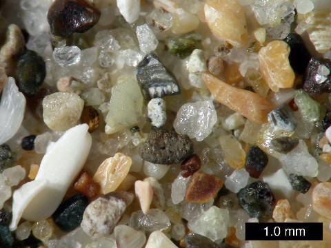
ISO 14688 grades sands as fine, medium and coarse with ranges 0.063 mm to 0.2 mm to 0.63 mm to 2.0 mm. In the United States, sand is commonly divided into five sub-categories based on size: very fine sand (1?16 - 1/8 mm diameter), fine sand (1/8 mm - ¼ mm), medium sand (¼ mm - ½ mm), coarse sand (½ mm - 1 mm), and very coarse sand (1 mm - 2 mm). These sizes are based on the Krumbein phi scale, where size in ? = -log base 2 of size in mm. On this scale, for sand the value of ? varies from -1 to +4, with the divisions between sub-categories at whole numbers.
Constituents
The composition of sand is highly variable, depending on the local rock sources and conditions. The bright white sands found in tropical and subtropical coastal settings are eroded limestone and may contain coral and shell fragments in addition to other organic or organically derived fragmental material.
Arkose is a sand or sandstone with considerable feldspar content, derived from the weathering and erosion of a (usually nearby) granitic rock outcrop.
Some sands contain magnetite, chlorite, glauconite or gypsum. Sands rich in magnetite are dark to black in colour, as are sands derived from volcanic basalts and obsidian. Chlorite-glauconite bearing sands are typically green in color, as are sands derived from basaltic (lava) with a high olivine content.
Environments
Sand is transported by wind and water and deposited in the form of beaches, dunes, sand spits, sand bars and related features. In environments such as gravel-bed rivers and glacial moraines it often occurs as one of the many grain sizes that are represented.
Study
The study of individual grains can reveal much historical information as to the origin and kind of transport of the grain. Quartz sand that is recently weathered from granite or gneiss quartz crystals will be angular. It is called grus in geology or sharp sand in the building trade where it is preferred for concrete, and in gardening where it is used as a soil amendment to loosen clay soils.
Sand that is transported long distances by water or wind will be rounded, with characteristic abrasion patterns on the grain surface.
People who collect sand as a hobby are known as arenophiles. Organisms that thrive in sandy environments are psammophiles
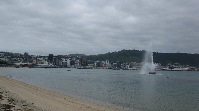
Oriental Bay - Wellington.
Introduction
Wellington City Council upgraded the Oriental Bay foreshore by enlarging and enhancing the existing Freyberg and Oriental Bay beaches, and creating a new beach east of the Band Rotunda.
There is now more sandy space for Wellingtonians and visitors to the city to enjoy walking, playing or relaxing. More than 27,000 tonnes of sand, from a site inland of Golden Bay in the northern region of the South Island, was placed on the beaches.
The entire project was funded by approximately $4 million from the Wellington City Council and approximately $3.5 million from the Plimmer Bequest. The existing sand is not a natural product of the Wellington harbour.
The sea wall around Oriental Bay stops any normal degradation of the coastline by wind and water and the coastline is not shaped in a way to capture sand. This area of the harbour is extremely vulnerable to the batterings of northerly storms which tend to move the sand away from the Bay.
Concept Development
Over the last 50 years, Oriental Bay's foreshore has evolved in a very unplanned way especially around the Freyberg area. Sand, which came from overseas, was dumped there during World War 2. From then on there have been several different haphazard changes and additions.
The Wellington City Council had to make a decision, either to let Oriental Bay degrade and in time have the sand shift away from the shore due to the severity of the storms that Wellington experiences, or given the Bay's popularity, do something to improve the area. The “Wellington Waterfront Development" project focused on the nearby waterfront which extends along Taranaki Wharf and in front of Te Papa, Museum of New Zealand.
The development project was the “Waterfront Park" which will transform the Chaffers area between Te Papa and Oriental Parade. The Oriental Bay foreshore development project is technically not part of the “Wellington Waterfront" project but is a geographic extension of it. The very strong link between the two and the popularity of Oriental Bay were good reasons to improve the standard of the area. No matter what time of the day or night, workdays, weekends, public holidays people can be seen walking, boating, relaxing, or exercising around the foreshore of central Wellington and Oriental Bay.
The catalyst for the project was a proposal put forward in 1996 to construct a small new beach east of the Band Rotunda. This proposal expanded into one to redesign Oriental Bay's entire foreshore area spanning 800 metres of coastline.
The sand as reclamation and its retention
The existing sand is not a natural product of the Wellington harbour. The sea wall around Oriental Bay stops any normal degradation of the coastline by wind and water and the coastline is not shaped in a way to capture sand. This area of the harbour is extremely vulnerable to the batterings of northerly storms which tend to move the sand away from the Bay.
A barge measuring 100 metres in length and 25 metres in width was used to bring sand, from a hillside near Takaka, to its new home at Oriental Bay. By the end of May 2003, nearly two thirds of the new sand was deposited on the main Oriental Bay beach and the new beach east of the Band Rotunda, where it is being filtered and shaped by the waves and tide.
The new sand appeared to be “washing away" off the beaches, but this is all part of the process of building the beach. The new sand, because it came from a hillside hadn't been naturally sorted by sea or river water. It has been intentionally placed with a steep edge so the waves will wash over it and filter out finer, almost silt-like materials – leaving on the beach the heavier grains of sand. The sand will also change colour as the finer grains are filtered out, leaving a lighter coloured sand behind.
Silt from sand was also dumped further out in the bay and sand from the mouth of the Hutt River is being used to fill in a natural depression on the harbour bed near Freyberg Beach – when the sand was dumped into the depression, a plume of silt discolours the water, making it look like sand is being washed out to sea.
One very important aspect in relation to the sand was the relationship with Iwi as a stakeholder. Wellington City Council managed this issue right from the outset before any decisions were made and continued to be in constant contact and communication with local Iwi throughout planning. Both Iwi from the north and south were comfortable with the transporting of sand from Golden Bay to Wellington.
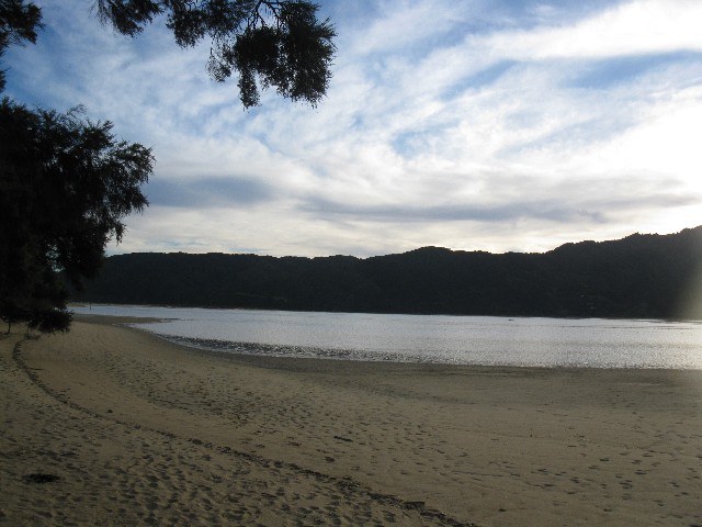
Golden Bay - Takaka.
Location
This location is made up of Separation Point Granite (Top layer) and Rameka Intrusive from Mid Devonian to Carboniferous which about 300 - 280 MYBP
Rameka Intrusive
Diorite, gabbro, norite and amphibolite are the main rock types in a large intrusive body at Rameka Creek on the Pikiruna Range. The intrusion is in the form of a folded silt or laccolith below the Mount Arthur Marble and has given rise to a variety of skarn rocks at marble contacts.
The sills show strong segregation of dark and light minerals suggestive of primary laying. Minor sepintines and gabbro's intrusive's into Ordovican rock elsewhere , and the Rameka Metavolcanics are probably related to the Rameka Intrusive. A Devonian age is likely.
Separation Point Granite
The Eastern highlands are formed of the Separation Point Granite, light coloured sodic to calc-alkali biotite granites, hornblende granites, syenite's and quartz diorite's.
For over 50 miles along the eastern highlands, granite concordantly underlies the Mount Arthur Marble. Contacts show inter-lamination of marble and granite and no contact alteration or chilling, thus indicating that marble and granite were isogradic at the time of metamorphism. A possible explanation is that the granite was formed in a place from granitised Ordovician sediments underlaying the marble.
The age of the Separation Point Granite is post Devonian and probably Carboniferous, as pebbles or similar granite appear in early Permian sediments of East Nelson.
Earthcache Tasks
There is four waypoint's that you must go to, to complete the task required to claim this Earthcache, you will also need to make and gather some extra equipment to be able to complete some of these task. All "TASKS" must be completed before you are able to claim this Earthcache.
Extra equipment
The following is a list of equipment that you will need to help you complete the following experiments. You will also be required to make you own hourglass to be able to complete all the required task.
More info can be found at the following Web page or you can google your own search.Link to making you own hourglass
Plastic cup
Electronic Scale
A Stopwatch or an accurate timekeeping device.
film canisters
Calipers or a very accurate ruler
Questions
All the results of each experiment and the answers for the following questions "MUST" be emailed to the owner before you can claim this Earthcache unless otherwise specified. Please "DO NOT" spoil it for other cachers that follow by posting spoilers.
Q 1: What is the most common constituent of sand in inland continental settings and non-tropical coastal settings called?
Q 2: What is the logarithmic scale for measuring sand called?
Q 3: Named 4 types of minerals that are found in the composition of sand?
Q 4: What is the geological term for Quartz sand called?
Q 5: Organisms that thrive in sandy environments are called what?
Q 6: Name 6 major industrial uses that sand will be required for?
Q 7: At the following waypoint S41 17.467 E174 47.576, a you will find 3 objects, a Chondrichthyes and two molluscs. What is their general name of these 3 sea creatures?
Q 8:According to the Wellington City Council, how many tonnes of sand was moved?
Q 9: Identify the two main formation which contribute to the sand in Golden Bay
Q10: What is the estimated MYPB
Q11: What does MYPB stand for?
Q11: What minerals forms this granite
Q12: At the following waypoint S41 17.444 E174 47.770 please describe in you own words standing facing the sea what the difference between the east and west of where you stand.
Experiments
Locations
S41 17.444 E174 47.770
S40 48.587 E172 56.758
At these two co-ordinates you can to take your samples of sand that you need for this experiments. You may need to take up to 100 grams. If the sand is wet you will need to dry it out.
Once you have your samples you will need to complete the following experiments: Once finished return the sand back to where you got it from.
1: Tip your sample into a plastic cup, then rotate your cup in a circular motion (creating a centrifuge effect) for 20 - 30 rotations. Tap cup gently on a flat surface once or twice to level out the sample.
2: Describe the layers of grain sizes from top to bottom.
3: Sieve your sample though a kitchen sieve to separate the coarse and fine grains, once done describe the sample and colours you observe.
4: Weigh the coarse and fine grain separately and record the weights.
5: Using the Wentworth scale classified your sample.
6: Now make your hourglass with a 1.0 - 4.0 mm hole (Whatever is required for the size of the sand.)
7: Tip your fine sand into the hourglass after taking the weight (Weight = X), tip the container with the sand on top and measure the time it takes for the sand to empty from the top to the bottom container (Time = Y) and calculate the flow speed amount of grams / second (Z). Email the answers for X and Y, and Z.
8: Create a "Sand Mandella", be creative and post a picture of your Sand Mandella with your online log.
At S41 17.454 E174 47.752(Optional) you will need to take a photo of the predominant man made object that is in the water and the surrounding background and the view beyond with you or your GPSr in the photo please place this with you online log.
At S40 48.587 E172 56.758 (Optional)you will need to take a photo of the escarpment that is across the water and the surrounding background and the view beyond with you or your GPSr in the photo please place this with you online log.
|

|

|

|
|
kiwicouple
|
isis58 |
????????? |