IATCC - Devils Lake EarthCache
-
Difficulty:
-

-
Terrain:
-

Size:  (not chosen)
Please note Use of geocaching.com services is subject to the terms and conditions
in our disclaimer.


This is an Earthcache and as such there is no physical container to find or log to sign. Failure to complete the logging requirements listed below may result in the deletion of your "Found it" log without notice.
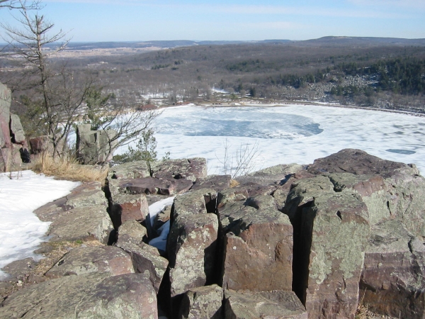
North Shore
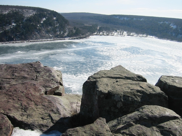
South Shore
Devils Lake
Approximately 1.85 billion years ago this area was covered by an ancient sea. For 200 million years the tributaries flowing into it carried quartz sand grains which were deposited in layers and cemented together, creating sandstone. A crustal disturbance occurred, just to the south of here, about 1.65 billion years ago. The immense heat and pressure caused the sandstone to metamorph into Quartzite and create the Baraboo range, which includes Devils Lake. The layer of quartzite in this area is estimated to be over 4,000 feet thick. As the uplift occured the sea receeded but a river continued to flow through this gap, eroding away the softer rock and creating the gorge between the east and west bluffs.
When the glaciers advanced into Wisconsin between 60,000 - 15,000 years ago, it altered the Devils Lake area again. The Green Bay lobe of the Laurentide Ice Sheet was diverted by the massive quartzite cliffs. The glacier wrapped around the bluffs advancing into both the north and south ends of the gorge. When the glacier melted back it left behind ridges of soil, gravel and rock. These ridges, called moraines, dammed both ends of the gorge, creating the Devils Lake basin. As the ice sheet melted, the large volume of water filled the basin and altered the drainage of the area, rerouting the river that once flowed through the gorge. It is estimated that the level of Devils Lake then was up to 100 feet higher than it is now.
The Devils Lake Nature Center sits atop the terminal moraine on the North Shore. A terminal moraine marks the spot where a glacier reached it's maximum extent before retreating. Inside the Nature Center are 4 dioramas with views of Devils Lake during the geologic events that created it. I highly recommend a stop at the Nature Center if time allows.
Your hike from the boat landing parking to the top will be about 0.8 mile. Follow the West Bluff Trail, which is also part of the Ice Age Trail, to the top. The listed coordinates will take you to an overlook with an informational sign. Use it and your compass to answer the questions below. Email your answers to me.
Logging Requirements
Failure to email the answers to me OR posting your answers online will result in your log being deleted.
From the overlook at GZ:
1) Estimate the direction, in degrees, to the center of the morraine blocking the north end of the gorge.
2) Estimate the direction, in degrees, to the center of the morraine blocking the sorth end of the gorge.
3) Briefly describe how the glacier's advance to this area changed the landscape.
Pictures of the view are optional but appreciated.
This cache is located in Devil's Lake State Park. A vehicle admission sticker is required.
The Devil's Lake State Park map will be a helpful resource when seeking this cache.
The Geocache Notification Form has been submitted to Steven Schmelzer of Devil's Lake State Park. Geocaches placed on Wisconsin DNR managed lands require permission by means of a notification form. Please print out a copy of the notification form, fill in all required information, and then submit it to the land manager. The DNR Notification form and land manager information can be obtained at http://www.wi-geocaching.com/hiding
IATCC is the cache designation to highlight a series of EarthCaches along the Ice Age National Scenic Trail grouped into a special category called "COLDCACHE."
The Ice Age Trail is one of eleven National Scenic Trails designated by the National Park Service. This unique trail is entirely within the state of Wisconsin and follows along the terminal moraine of the most recent glacier.
This project is supported by the Ice Age Trail Alliance. The goal is to bring more visitors to the trail and promote public awareness, appreciation, and understanding of Wisconsin's glacial landscape. For those who have the Ice Age Trail Atlas, this site is located on map 61f.
More information on the Ice Age Trail Atlas, the ColdCache Project and Awards Program is available at http://www.iceagetrail.org/coldcache.htm.
Additional Hints
(No hints available.)