Türkçe metin, Deutscher Text
Earthquakes in Istanbul
The never ending story
Questions:
The effects of the earthquakes of the past show up everywhere in Istanbul. Look around Hagia Sophia and find traces of past earthquakes. You may find them both inside as well as outside, so it's not necessary to enter Hagia Sophia with costs.
Send me an e-mail in which you describe the trace in your own words. Go here for the used materials and rock species that have been used to build the walls. What structures have withstood the earthquakes well? How do the traces of ancient earthquakes show today? It would be nice if you could attach pictures of the traces to your log.
Alternative:
Find a place in Istanbul where the consequences of earthquakes are visible. Mention its coordinate and describe the location it in your log. It would be nice if you also attach pictures of it to your log. With the help of your logs, I can expand the waypoints / map and can thus contribute to the documentation of this issue.
You need not wait for permission to log. But I reserve the right to send questions to your log and delete it if necessary.
1. The evolution of Istanbul
Istanbul was founded BCE 660th by Dorian Greeks as a colony on the European shore of the Bosphorus and so can look back on more than 2,600 years of history. In that time it was the capital of three empires and major center of two world religions.
After Emperor Constantine I united both parts of the united Roman Empire in 324 ,the new capital was known as Constantinople in honor of him. From 412 Theodosius II fixed the city by the still visible Theodosian wall and supplied water through aqueducts. Constantinople was now the largest and richest metropolis in the Mediterranean for centuries, with an area of 12 km². In the 6th Century, Constantinople developed magnificent under Emperor Justinian, and e.g. Hagia Sophia was built. From the mid-11th Century decreased the importance of Constantinople.
In 1453, the largely ruined and depopulated town was occupied by the Ottomans under Mehmet II after a long siege. As a result, it was tactically settled and built up again. Under Sultan Süleyman I and his architect Sinan, the city reached another period of prosperity in the 16th Century. Many mosques, palaces, bridges and wells were built and partially showing up today. Since that time Konstantiniyye was sometimes referred to Istanbul, until it was incorporated with that name in 1876 as official in the Constitution. With the decline of the Ottoman Empire its capital lost importance in the early 20th Century.
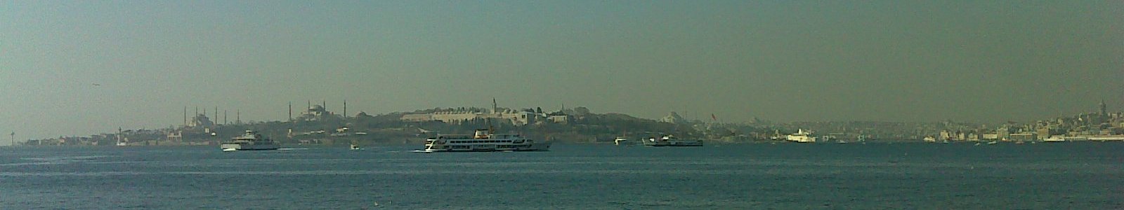
In 1923, after the Napoleonic wars, the capital of the Turkish Republic moved to Ankara under Mustafa Kemal, known as Ataturk, mainly to delimit from the Ottoman tradition. Istanbul today has an expansion of about 50 km in N-S and 100 km in E-W direction and is the third largest megacity in the world with an estimated 14-16 million inhabitants.
2. Earthquakes in Istanbul
Istanbul has always been shaken by serious, sometimes devastating earthquakes.
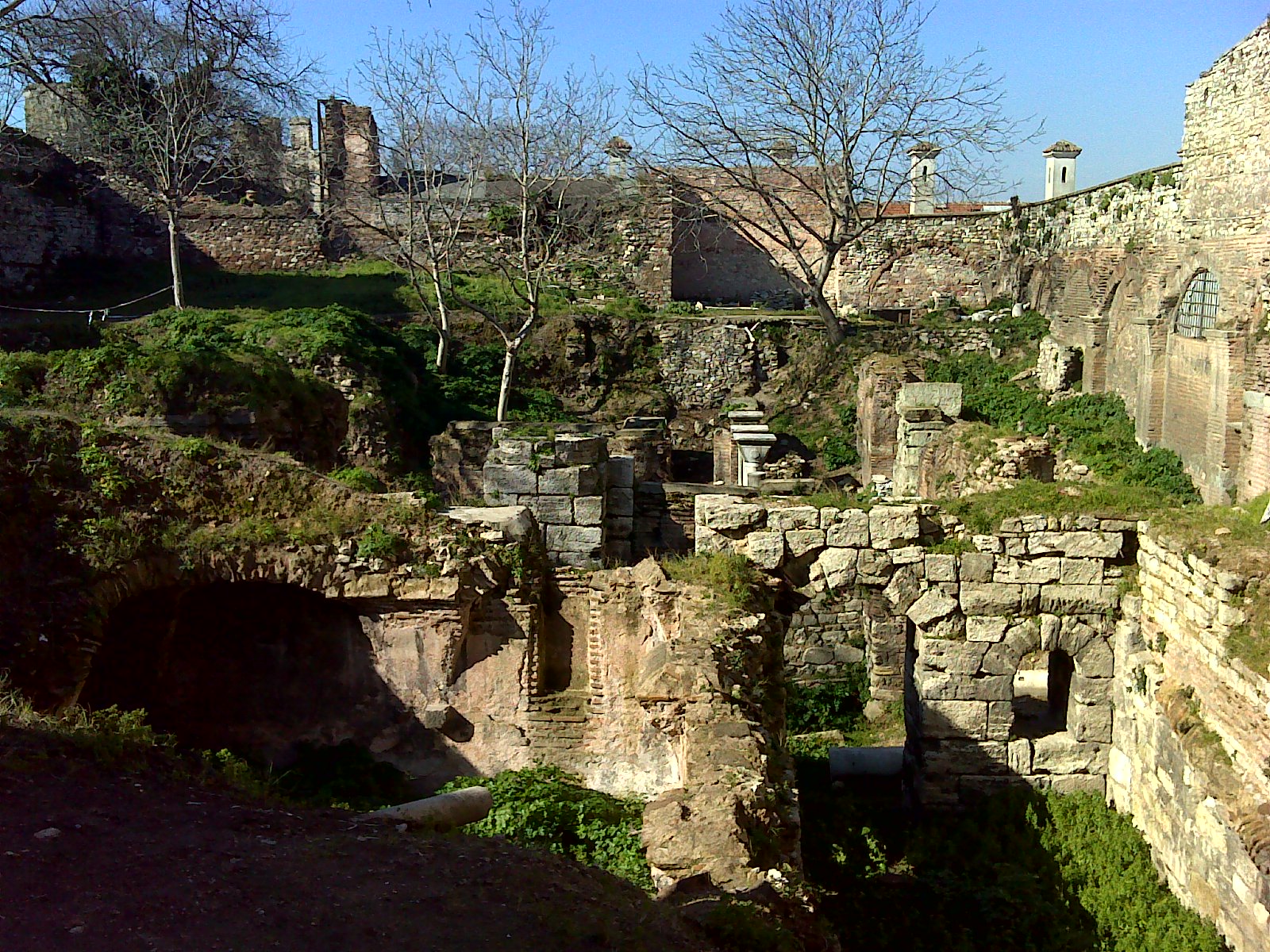
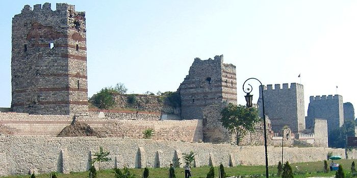
In the event of 447 fell 57 towers of his time unique Theodosian Wall, which protected Byzantine Constantinople to the west over a length of about 20 km. The ruins of fortress walls are still visible near the Ataturk airport today.
In 1509 an earthquake destroyed, together with a huge tidal wave that swept over the seawall, 109 mosques and 1070 houses. It is estimated 5,000-13,000 people were killed and the Ottoman fleet was almost completely destroyed.
Other strong earthquakes followed in 1559, 1690, 1719 and 1766. In 1894 an earthquake collapsed parts of the roof to the main bazaar, and numerous mosaics of Hagia Sophia were destroyed.
With the increasing population of Istanbul is also increasing the devastating effect, that is stimulated by earthquakes. The earthquake at Izmit in 1999 with a magnitude of 7.6 on the Richter scale, over 17,000 people were killed and nearly 44,000 people were injured. It is seen only as a harbinger of an even stronger earthquake until 2025, expected by geologists.
3. Causes of the earthquakes in Istanbul
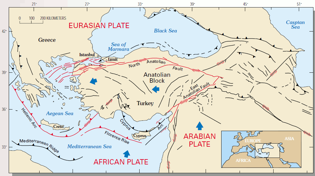
The geological situation around Istanbul is very complex and has its beginnings before the Paleozoic. The Mediterranean was already established as a zone of weakness on the super continent Pangaea. Here Pangaea shared in the southern continent of Gondwana and the northern Laurasia. To Laurasia included the present-day North America, Europe and Asia, to Gondwana South America, Africa, Australia, India and Antarctica. During the Jurassic about 200-145 million years ago formed between the two continents due to their divergence the Tethys Ocean. About 100 million years ago during the Cretaceous was reversed by the divergent movement, and Africa since then drifts northward. It emerged from the African Plate under the Eurasian and forms including the eastern Mediterranean to this day a subduction zone. Due to the collision of the two great continental plates since 50 million years ago, their edges broke off into numerous micro-plates, which since then perform a rotational movement between the large plates.
One of the fragments is the Anatolian microplate, which moves at a speed of 2-3cm per year westward. In the area of Turkey is not a subduction zone formed, but the plates move against each other here. This type of collision is called transform fault. The geological situation in this respect is very similar to the U.S. San Andreas Fault. A portion of the northern edge of the Anatolian microplate is stuck in Asia and there hooked on the North Anatolian Fault. This prevents a continuous movement, which would translate into many smaller quakes, but runs jerkily to defuse tension, when it has become too large. This caused so not quite as frequent, but therefor much stronger quakes.
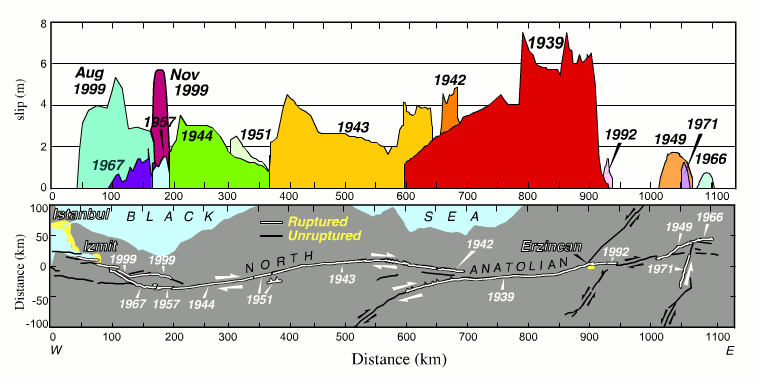
In the past 100 years, the seismic centers of the earthquakes were shifted to the west, which runs on to Istanbul. It was found that never the entire microplate is moving, but only a part of about 100 km in length. In this part the pressure is reduced after, however, at its western end it is raised even more and will be discharged there years to decades later. Thus, the immediate threat is emerging in Istanbul, because Izmit is only 80km east of the city.
The Kandilli Observatory Earthquake Research conducts intensive research with the aim of the next earthquake to detect as early as possible. So shall such automatic systems include gas pipelines, trains stop and stop traffic using traffic lights going red. But for timely early warning of the population there is so far still no way.
4. Magnitude of earthquakes
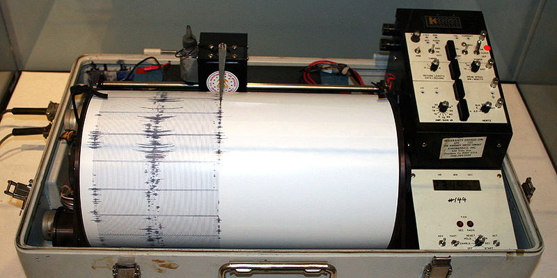
The strength and destructive power of earthquakes is measured by seismographs and today generally determined on the open-ended Richter scale. It was developed in 1935 in California for the frequent earthquakes occurring there. So any earthquake strengths can be measured, but levels greater than 9.5 are practically impossible to reach, because the rock can not save more energy, and before discharge. The value on the Richter scale is called the 'magnitude'. It is derived from the maximum deflection of a seismometer, that is established in 100km distance to the epicenter of the earthquake. A plus 1 of magnitude is equivalent to ten times the deflection of the seismometer and thus about 32 times a release of energy. The following table describes the classes of magnitude of the Richter scale:
|
Richter Magnitudes
|
Description
|
Earthquake effects
|
Frequency of occurrance
|
|
< 2.0
|
Micro
|
Micro earthquakes, not felt
|
˜ 8,000 per day
|
|
2.0 … < 3.0
|
Minor
|
Generally not felt, but recorded
|
˜ 1,000 per day
|
|
3.0 … < 4.0
|
Minor
|
Often felt, but rarely causes damage
|
˜ 49,000 per year (est.)
|
|
4.0 … < 5.0
|
Light
|
Noticeable shaking of indoor items, rattling noises. Significant damage unlikely.
|
˜ 6,200 per year (est.)
|
|
5.0 … < 6.0
|
Moderate
|
Can cause major damage to poorly constructed buildings over small regions. At most slight damage to well-designed buildings.
|
˜ 800 per year
|
|
6.0 … < 7.0
|
Strong
|
Can be destructive in areas up to about 160 kilometres (100 mi) across in populated areas.
|
˜ 120 per year
|
|
7.0 … < 8.0
|
Major
|
Can cause serious damage over larger areas
|
˜ 18 per year
|
|
8.0 … < 9.0
|
Great
|
Can cause serious damage in areas several hundred miles across
|
˜ 1 per year
|
|
9.0 … < 10.0
|
Great
|
Devastating in areas several thousand miles across
|
˜ 1 per 20 years
|
|
10,0 … 8
|
Epic
|
Never recorded
|
Extremely rare (Unknown)
|
5. To the location
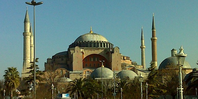
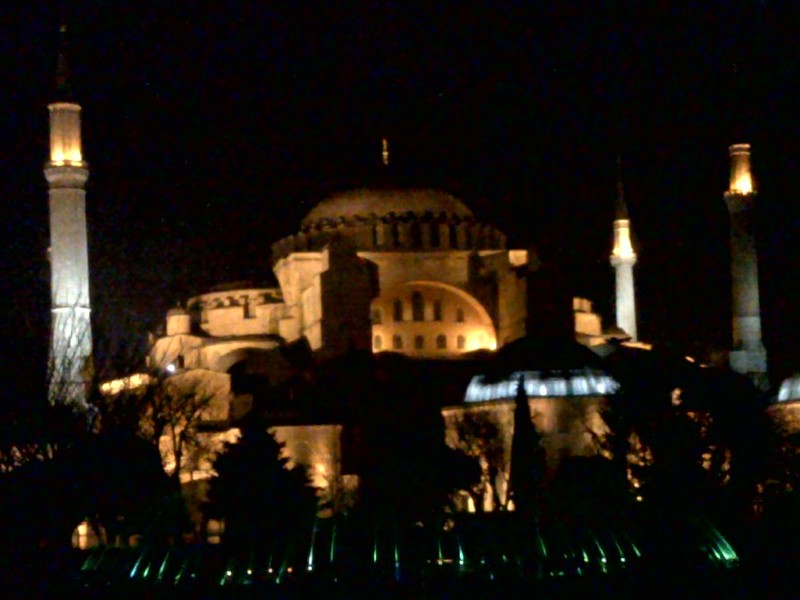
Hagia Sophia is a late antique building. It was the first Byzantine church, later mosque and now a museum. Its shell was finished in 537. It stands on the fundament of two smaller predecessors. During the construction period there were always smaller cracks in the brickwork. While the Romans have built successfully large dome structures, which have only been realisable through the use of the 'Roman concrete' Opus caementitium, Hagia Sophia was built in a classic east Roman construction with brick.
Shortly after its completion, the too flat curved dome fell in during an earthquake. It was replaced by a more curved dome, but a short time after this construction cracked, too. Then windows were installed in the lower part of the dome, which should prevent their collapse, allowing forming cracks to run into the void.

Again and again parts of Hagia Sophia collapsed in the aftermath. So from the 14th Century retaining walls were added at their outer sides. They changed the appearance considerably, but the risk of collapse could not be removed until today. The current status is regularly tested with radar technology with the aim to create a sustainable concept of conservation in the future.
The change from the church to the mosque since 1453 is facing out especially by the surrounding four minarets of Hagia Sophia. At the suggestion of Ataturk in 1934 Hagia Sophia was rededicated as a museum, which makes all the phases of its religious use accessible.
It is precisely the problematic, free-floating, giant dome of Hagia Sophia, that makes it so unique up to this day. For a millennium it was in late ancient world and the Middle Ages by far the largest church of Christianity, and even was known as the eighth wonder of the world. Today it is a UNESCO World Cultural Heritage.
Sources:
Istanbul: http://de.wikipedia.org/wiki/Istanbul
Measuring earthquakes: USGS: FAQ- Measuring Earthquakes
Richter scale: http://de.wikipedia.org/wiki/Richterskala
North Anatolian fault: http://de.wikipedia.org/wiki/Nordanatolische_Verwerfung and http://records.viu.ca/~earles/anatolian-mar00.htm
Bogazici University - Kandilli Observatory and Earthquake Research Institute: http://www.koeri.boun.edu.tr/eng/topeng.htm
Hagia Sophia: http://de.wikipedia.org/wiki/Hagia_Sophia
All images were even photographed during a visit to Istanbul in February 2011 or taken from Wikipedia, or taken from USGS. If not otherwise stated, they are published under the "GNU Free Documentation License".