Great Sand Bay EarthCache
-
Difficulty:
-

-
Terrain:
-

Size:  (other)
Please note Use of geocaching.com services is subject to the terms and conditions
in our disclaimer.

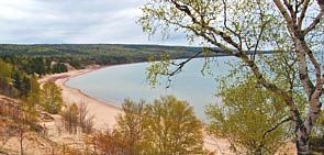
Great Sand Bay - Keweenaw Penninsula -
Michigan
The Great Sand bay is a stretch of beach, water, and sand dunes
that span over a thousand feet. It is one of the largest stretches
of sand beach on the Keweenaw Peninsula, and it's shore has several
rocky sections mixed with the sand dunes. The bottom of the bay is
covered in a thin layer of pristine white sand.
Lake Superior drops off gradually here, going barely over five feet
in depth for a hundred feet or so into the bay itself. There is a
large and wide sandbar further out into the bay which lowers the
depth further to just a few feet. In contrast, approximately 10
miles out, you will find some very deep areas of Lake Superior. On
account of the shallowness of the Great Sand Bay, it tends to
create some impressive wave action.
History of Sand Dune formation
As recently as 16,000 years ago, Michigan was covered with glacial
ice thousands of feet thick. This glacial ice contained a mix of
boulders, cobbles, sand, and clay. During glacial melting, this
deposit was left and is known as glacial drift.
This glacial drift is the source of sand in most of Michigan's
dunes. The sands were either eroded from glacial drift along the
coast by wave activity or eroded from inland deposits and carried
by rivers and streams. Only the hardest, smallest, and least
soluble sand grains were moved. Waves and currents eventually moved
these tiny rocks inland, creating beaches along the Great Lakes
shoreline.
Winds, blowing shoreward at speeds of 8 to 25 miles per hour, begin
to move the sand grains. The size of grains which are moving is
directly related to wind velocity larger grains require higher wind
speeds. These bouncing sand grains resemble tiny, skipping ping
pong balls as they are moved by the wind through a process called
saltation. Colliding with each other, barely a foot or two off the
ground, they may meet a slight obstruction, such as a clump of
grass, which deflects the wind and allows sand grains to drop. Thus
a slight mound or hummock is created.
 The wind continues to push sand grains up the
windward side of the dune crest, causing the dune to grow in the
downwind direction. Many sand grains continue moving and eventually
roll down the steep backslope. A dune is slowly being formed, and
its continued growth depends upon perennial vegetation, wind, and
sand. Because dune plants act as barriers to sand movement and hold
migrating sand, they play a critical role in the formation and
stabilization of dunes.
The wind continues to push sand grains up the
windward side of the dune crest, causing the dune to grow in the
downwind direction. Many sand grains continue moving and eventually
roll down the steep backslope. A dune is slowly being formed, and
its continued growth depends upon perennial vegetation, wind, and
sand. Because dune plants act as barriers to sand movement and hold
migrating sand, they play a critical role in the formation and
stabilization of dunes.
The sand dunes of the Great Lakes region represent the largest
freshwater coastal dunes in the world. These dunes are only
3,000-4,000 years old - that's very young, geologically
speaking.
Types of Sand Dunes
There are three major Dune Types: Perched dunes, Parallel
dunes, and Blowouts.
Perched dunes are some of the more famous and most spectacular land
features in Michigan. They are actually wind blown sand dunes
perched atop glacial moraines. Glacial moraines, common landforms
in Michigan, are ridges of sand, gravel, stone or clay left by
retreating glacial ice. The moraines lying along the present
shoreline of the Great Lakes were subjected to wind and wave
erosion. Sand, moved by waves and long shore currents, was blown up
the steep faces of the moraines by on shore winds, accumulating
along the summits and leeward sides, forming perched dunes.
Parallel dunes are series of low, linear dunes formed parallel to
the shores of large shallow bays. The parallel dunes along the
eastern shore of Lake Michigan were formed about 4,000 years ago
during the Lake Nipissing stage of Lake Michigan, when water levels
were 25 to 30 feet higher than present day Lake Michigan water
levels. Rivers entering the bays carried abundant sand, which was
then moved along the shore by lake currents. On shore winds formed
these sands into low lying dunes. As the water level of ancient
Lake Nipissing dropped, a series of parallel dunes were created.
They occurred in areas that were formerly wide bays in Lake
Nipissing.
Blowouts are saddle shaped or U shaped (parabolic) depressions in a
stabilized sand dune, caused by the local destabilization of the
dune sands. Blowouts, which originate on the summit or windward
face of a dune, are often rapidly formed by the wind, creating
narrow channels and exposing plant roots. Blowouts can create
interruptions in the shape of parallel dunes that may result in
deeply carved indentions called parabolic dunes. It is the
combination of interwoven parallel dune ridges and U shaped
depressions, including parabolic dunes, that characterizes the
classic dunes from Indiana, northward to Ludington, in
Michigan.
The moving sand from the blowouts often buries forests on the steep
lee slopes. Blowouts may also uncover the bleached trunks of trees
still standing after being buried in the dry sand for hundreds of
years. These "ghost forests" are silent testimonials to ancient
forests buried by blowouts in the past.
Blowouts have historically been caused by natural disturbances,
such as fires, wind storms, or plant diseases. However, in recent
decades, human activities and disturbance or destruction of sand
holding vegetation has initiated blowouts. Off road vehicle traffic
and human foot traffic are major causes, but clearing of protective
dune vegetation to build homes, cottages, and commercial buildings
has also resulted in large scale wind erosion man made blowouts.
Continuous human disturbance has the potential for much more
widespread destabilization because it does not allow blowouts to
stabilize.
Logging Requirements
In order to log this Earthcache send the answers to the following
questions to the Cache Owner.
- What type of sand dunes make up the Great Sand Bay?
- How old are the sand dunes here?
- (optional) While it is not required to take a picture, we enjoy
seeing pictures attached to logs of your visit to this area.
Additional Hints
(No hints available.)