Mali i Gjere massif located in the south of Albania, about 25 km away from town Saranda is an asymmetric anticline structure overturned. Easter side descend in northeast with angle 25-30° while the westside is detached tectonically till to riding. The Drinos-Saranda region is the main water pool in the Albanian territory related to carbonate deposits. In the karstie zones, the effective infiltration reaches a value of 45-55% of the annual rains. In the Mali i Gjere mountain, this value reaches 1200-1300 mm/year. (Tafi & Ennui, 2000). Water movement directions differ: for the lower horizon it is mainly towards the west, for two other horizons it is towards the east. The lower horizon (Upper Triassic - Lower Jurassic) is the most powerful one. It discharges considerable quantities of water in the Syri Kaltert, Kardhikaqi or Navarica springs. The springs are located at the contact between evaporite deposits in north and flysch deposits in south. Syri i Kalter (in English means "blue eye") is the main and biggest out of 18 springs in this area. This geological phenomenon and biggest karst spring in Albania is situated 177 meters above the sea level, on the western slopes of Mount Mali i Gjere.
The spring is located near the tectonic contact between the Mesozoic-Paleogenic Mali i Gjiere carbonate sequence and the Terziary flysch units of the “Ionian Zone” of Albania. The reason why is spring formed in this location is a result of complicated underground channel system into the massiv, where we can observe also some kind of "underground piracy" (Stevanovic 1994), where is one branch of spring "stealing" the water to another one, using the influence of basic physical process such a pressure and slope of the massiv. But the detailed research of the hydrosystem in this area is unfortunately absenting. 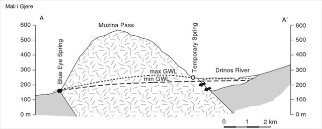 Anyway the karst networks in Albania clearly appear different from the fracture pattern of respective karst structures (Mandel 1963). They are organised more like fluvial systems. This happens even when the direction of bedding plains is perpendicular to that of the hydraulic gradient, as is the case of the Blue Eye Spring. The discharge area is characterized by the presence of Triassic evaporites, mainly constituted by gypsum and anhydrite, associated with clay, limestones, dolomite and halite. Based on isotopic investigations during years 1989-1990 and again in 1996, it is confirmed that the recharge resources of spring consist of precipitation (about 70%) and Drinos valley groundwater seepage into the massif ( about 30%) trough the Alluvial Plain (Eftimi, Amataj, Zoto 2007). The spring feeds the 25 km long Bistrica river, flowing to the Sarande Bay in Ionian Sea. The average yearly discharge of the Blue Eye Spring is about 18.4 m3/s and water flows at a temperature of 10 °C. The clear water of Syri i Kalter spring is coming from more than 70 m deep pool, but it is still unclear what the actual depth of the karst hole is. The Blue Eye drainage siphon has been explored by divers, first by an Italian team in 1992 then by French divers that reached a depth of 70 m (Touloumdjian, 2005). It was extremely difficult to dive against very strong ascending flow. After several attempts, this was achieved with support of 20 kg weight belts and special ropes.
Analyses of water samples from the spring show relatively high concentrations of calcium, sulphate (about 135 mg/l) and alkalinity, with a minor magnesium content and low concentrations of alkali-ions and chloride. The hydrochemical type of spring is: HCO3–SO4-Ca.
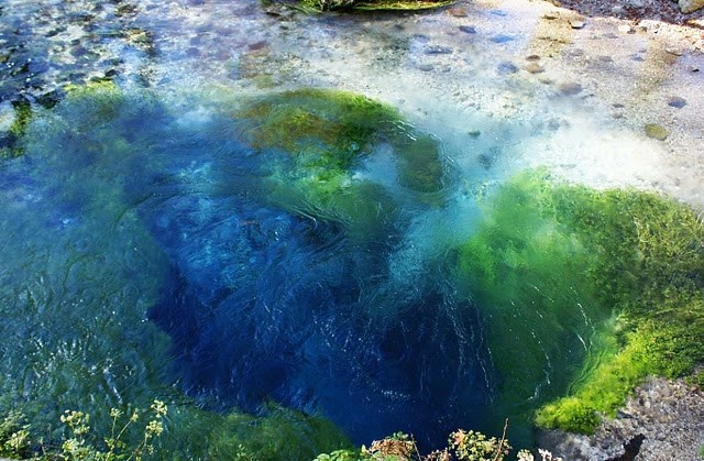
The water in the inner part of the spring appears very dark blue, like the pupil of an eye, and a lighter colour of blue as an outer ring (the iris), which gives the impression of a blue human eye. It is said the Blue Eye was blocked off to the general population during the communist days, only to be enjoyed by the ruling party members. The ancient legend tells that the waters sprung to the earth from a dragon that was burned by a clever peasant who had fed it a mule loaded with touchwood and cinder. The Syri i Kalter is inseparable part of every tourist guide of Albania. Next to a picturesque waterfall opposite the "Blue Eye" spring, there is a wood and stone built restaurant you may enjoy Albania's traditional food, such as roast lamb and grilled fish.
The Albanian Center for Marine Research with support from RPM Nautical Foundation conducted a scientific survey of the Blue Eye spring on July 2011. The underwater archaeologists dove to examine a plateau at twenty meters to find the evidence of ritual use of spring in the past. The vast majority of items were modern, such as broken glass, concrete, and iron pieces. There was potential evidence of older use, such as wood and animal bones. One bone showed evidence of cooking, which could point to ancient sacrifice where a feast would be prepared and animals killed in the honor of a deity.
If you want to log this cache:
Obligatory task:
1. Could you with your own words explain, what cause the two colour of water? 2. Could you find on the table, near spring, how much was the awerage flow in year 2002 and trying to guess, using the information from the eartcache text, why?
Optional task: take a picture of you in front of the spring and upload the image to your log.
Send me your answers via email and log the Earthcache. If there would be a problem with your answers, I will contact you. Do not post the answers to the log. All logs, that are not connected with the aswers on my email, will be deleted.
--------------------------------------------------------------------
Kjo earthcache do të ju merr në pranverë natyrore me ujë të pastër, konsiderohet gjerësisht si një treasure.It kombëtar natyror është cache lehtë e arritshme edhe me makinën me parkim mundësinë për metra çift lirë nga cache.
Mali i Gjere masiv gjendet në jug të Shqipërisë, rreth 25 km larg nga qyteti i Sarandës është një strukturë asimetrike antiklinalë përmbys. Pashkët anë të zbresë në verilindje me kënd 25-30 ° ndërsa Westside është shkëputur tectonically deri të hipur. Drinos-Saranda rajon është pishinë kryesor i ujit në territorin shqiptar në lidhje me depozitat karbonatike. Në zonat karstie, infiltrimi në fuqi arrin një vlerë prej 45-55 për qind të shirave vjetore. Në mal i Mali Gjere, kjo vlerë arrin 1200-1300 mm në vit. (Tafi dhe mërzi, 2000). Drejtimet Lëvizja e ujit ndryshojnë: për horizont të ulët është kryesisht drejt perëndimit, për dy horizonte të tjera ajo është në drejtim të lindjes. Horizonti i ulët (Upper Triasik - Jurassic Ulët) është më e fuqishme. Ajo shkarkon sasi të konsiderueshme të ujit në Kaltert Syri, e Kardhikaqi ose Navarica Springs. Burimet janë të vendosur në kontakt mes depozitave evaporite në veri dhe flishit depozitave në jug. Syri i Kalter (në anglisht do të thotë "sy blu") është kryesor dhe më i madh nga 18 burime në këtë fushë. Ky fenomen gjeologjik dhe pranverë e madhe karstike ne Shqiperi ndodhet 177 metra mbi nivelin e detit, në shpatet perëndimore të malit Mali i Gjere.
Pranverë është e vendosur në afërsi të kontaktit tektonik midis sekuencës Mesozoike-Paleogenic Mali i Gjiere karbonatike dhe njësive Terziary flishit të "Zonën Jonike" e Shqipërisë. Arsyeja pse është pranverë formuar në këtë vend është rezultat i sistemit të komplikuar nëntokësor kanal në MASSIV, ku ne mund të vëzhgojë edhe një lloj të "piraterisë nëntokësore" (Stevanoviç 1994), ku është një degë e pranverës "vjedhur" e ujit të një tjetër, duke përdorur ndikimin e procesit themelore fizike të tilla një presion dhe pjerrësia e MASSIV. Por hulumtim i detajuar i hydrosystem në këtë fushë është për fat të keq absenting. Gjithsesi rrjetet karstike në Shqipëri në mënyrë të qartë të shfaqet i ndryshëm nga modeli i thyerje e strukturave karstike përkatëse (Mandel 1963). Ata janë të organizuara si sisteme më lumor. Kjo ndodh edhe kur drejtimi i rrafshin shtrat është pingul me atë të gradient hidraulike, siç është rasti i pranverës Syri i Kaltër. Zona e shkarkimit është e karakterizuar nga prania e evaporites Triasik, kryesisht e përbërë nga gipsi dhe anhydrite, lidhur me balta, limestones, Dolomite dhe kripë guri. Bazuar në hetimet isotopic gjatë viteve 1989-1990 dhe përsëri në vitin 1996, është konfirmuar se burimet rimbushje prej pranverës përbëhet nga reshje (rreth 70%) dhe Drinos kullim lugina nëntokësore në masiv (rreth 30%) lug Plain aluviale (Eftimi , Amataj, Zoto 2007).Pranverë ushqen 25 km të gjatë lumit Bistricë, rrjedhin në gjirin e Sarandës në detin Jon.Shkarkimin mesatar vjetor i pranverës Syri i Kaltër është rreth 18.4 m3 / s dhe rrjedhat e ujit në një temperaturë prej 10 ° C. Uji i qartë i pranverës Syri i Kalter po vjen nga më shumë se 70 pishinë m të thellë, por ajo është ende e paqartë se çfarë thellësia aktuale e vrimë karstike është. Blue kullimit Syri kromi është hulumtuar nga zhytësit, së pari nga një ekip italian në vitin 1992, pastaj nga zhytësit francezë që kanë arritur një thellësi prej 70 m (Touloumdjian, 2005). Ishte jashtëzakonisht e vështirë të zhyten kundër rrjedhës shumë të fortë në ngjitje. Pas disa përpjekjeve, kjo u arrit me mbështetjen e 20 kg peshe rripa dhe litarë të veçanta.
Analizat e mostrave të ujit nga burimi tregojnë përqendrime relativisht të larta e, sulfat kalciumi (rreth 135 mg / l) dhe alkalinity, me një përmbajtje magnez vogël dhe përqendrimet e ulëta të alkali-joneve dhe klorid. Lloji hidrokimike e pranverës është: HCO3-SO4-Ca.
Ujit në pjesën e brendshme të pranverës blu duket shumë e errët, si nxënësit e një sy, dhe një ngjyrë më të çelët ngjyrë vjollce si një unazë e cekët (sipërfaqësore irisit), e cila jep përshtypjen e një sy blu e njeriut. Është thënë Syri i Kaltër është bllokuar jashtë në popullatën e përgjithshme gjatë ditëve komuniste, vetëm të jenë të gëzuar nga anëtarët e partisë në pushtet. Legjenda e lashtë tregon se ujërat çarë në tokë nga një dragua që u dogj nga një fshatar i zgjuar i cili e kishte ushqyer atë një mushkë ngarkuar me eshkë dhe zhir. Syri i Kalter është pjesë e pandashme e cdo guide turistike të Shqipërisë. Kërce tek një ujëvarë piktoreske të kundërt në pranverë "Syri i Kaltër", nuk është një dru dhe restorant gur ndërtuar ju mund të gëzojnë ushqim tradicional të Shqipërisë, të tilla si mish qengji rosto dhe peshku i pjekur në skarë.
Qendra Shqiptare për Kërkime Detare me mbështetjen e Fondacionit RPM Nautical kryer një studim shkencor të pranverës Syri i Kaltër në korrik 2011. Arkeologët nënujore pëllumbin për të shqyrtuar një pllajë në njëzet metra për të gjetur provat e përdorimit ritual të pranverës në të kaluarën. Shumica dërrmuese e artikujve ishin moderne, të tilla si xhama të thyer, beton, dhe copa hekuri. Nuk ishte dëshmi e mundshme të përdorimit të vjetër, të tilla si dru dhe eshtra të kafshëve. Një kockave tregoi provat e gatimit, e cila mund të pikëve për të sakrificës së lashtë, ku një festë do të jenë të përgatitur dhe kafshët vriten në nder të një hyjnie.
Nëse ju doni të hyni në këtë cache:
Detyra e detyrueshme:
1. Mund të me fjalët e tua shpjegoj, çfarë shkaktojnë ngjyra dy e ujit? 2. Mund të gjeni në tavolinë, pranë pranverë, sa ishte rrjedha awerage në vitin 2002 dhe duke u përpjekur të mendoj, duke përdorur informacionin nga teksti eartcache, pse?
Detyra Fakultativ: marrë një pamje të ju në frontin e pranverës dhe ngarkoni imazhin në log tuaj.
Dërgoni përgjigjet tuaja përmes emailit dhe hyni e Earthcache. Nëse nuk do të jetë një problem me përgjigjet tuaja, unë do t'ju kontaktojmë. Mos postoni përgjigje për log. Të gjitha shkrimet, të cilat nuk janë të lidhura me aswers në email time, do të fshihen.