Perguntas:
Para logar esse EarthCache, envie as respostas das perguntas abaixo através de email usando o meu perfil no geocaching.com. Coloque o texto "GC38T9K - Itaimbezinho" na primeira linha do email. Os cachers que não enviarem as respostas em no máximo 2 semanas terão suas entradas removidas.
1. Mande um email (não publique). Do ponto de observação P1, olhando através do cânion para o noroeste, qual é o elemento geológico natural (nome) responsável pelo contínuo alargamento do cânion?
2. Mande um email (não publique). Do ponto de observação P2, e olhando através do cânion para a parede no lado leste, quantas camadas de basalto você consegue contar da base para o topo do cânion? As camadas podem ser identificadas pelas linhas horizontais separando texturas diferentes do basalto e algumas vezes pela vegetação crescendo nas linhas entre as camadas.
3. Mande um email (não publique). Do ponto de observação P2, e olhando através do cânion para a parede do lado leste, qual é a espessura média (altura) das camadas de basalto?
4. Publique uma foto sua com o seu GPS e o cânion de fundo nas coordenadas do EarthCache. (opcional).
*! Parabéns Dekaru por ter sido o primeiro a logar este earthcache!*
Questions:
To log this EarthCache, cachers are asked to e-mail the answers to the following questions to me through my geocaching.com profile. Add the text "GC38T9K - Itaimbezinho" to the first line of the email. Cache loggers that do not send me answers within 2 weeks will have their logs deleted.
1. E-mail (do not post). From viewpoint P1 and looking across the canyon to the Northwest, what is the current natural geological feature (name) responsible for the continuous widening of the canyon?
2. E-mail (do not post). From the viewpoint in P2 and looking across the canyon to the wall on the East side, how many basalt layers can you count from the base to the top? The layers can be identified by horizontal lines separating different basalt textures and sometimes by vegetation clinging on the fissures between the basalt layers.
3. E-mail (do not post). From the viewpoint in P2 and looking across the canyon to the wall on the East side. What is the average thickness (height) of the layers
4. Post a photo of yourself with your GPS in hand with the canyon on the back at the EarthCache coordinates. (optional).
*!Congratulations Dekaru for the First To Find!*
Itaimbezinho
Chamado pelos índios Tupi-Guaranis de Ita Ai’be, significando “Pedra Afiada”, as escarpas abruptas onde animais em dias de neblina costumavam cair, foram aportuguesadas pelos colonizadores para Itaimbezinho, adicionando-se o sufixo -inho como diminutivo. O pequeno cânion da “Pedra Afiada”, ou Cânion do Itaimbezinho é uma maravilha geológica cuja criação abrange centenas de milhões de anos.
Localizado no Parque Nacional dos Aparados da Serra, o cânion Itaimbezinho tem 5,8 quilômetros de extensão, altura máxima de 700 metros, largura máxima de 2.000 metros e uma idade calculada em 130 milhões de anos.
Called by the region’s first nation – the Tupi-Guarani natives – Ita Ai’be, meaning “Sharp Rock” the abrupt cliffs where animals in foggy days used to fall, was approximated by the Portuguese European population colonizing the region to Itaimbezinho, where the suffix “zinho” means small. The “Small Sharp Rock” canyon, or Itambezinho Canyon is a geological marvel which creation spans hundreds of millions of years.
Located in the Parque Nacional dos Aparados da Serra, the Itaimbezinho canyon is 5.8 kilometres in length, 700 metres height, maximum width of 2,000 metres and an age estimated in 130 million years.
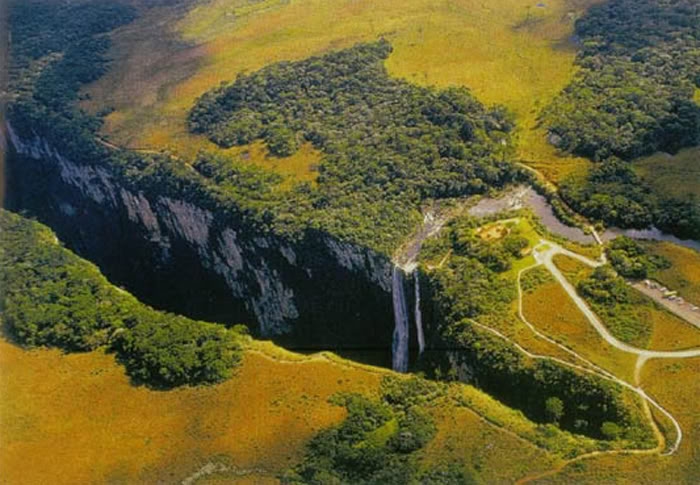
Canion Itaimbezinho – foto Aérea – aerial picture
A cerca de 137 milhões de anos atrás a Terra era formada por um único continente chamado de Pangea. O território onde hoje se localiza o cânion era constituído de um deserto chamado deserto Botucatu cobrindo a bacia sedimentar do Paraná. A região dos estados do Rio Grande do Sul, Santa Catarina e Paraná estava ligada a África na atual região da Namíbia. Há cerca de 125 a 135 milhões de anos, no início do período Cretáceo (145 – 65 milhões de anos atrás), placas tectônicas que constituíam esse super continente começaram a se mover. Erupções vulcânicas de grande escala começaram a ocorrer na região, mas diferente de explosões vulcânicas tradicionais, o magma que começava a recobrir vastas extensões do deserto provinha de fissuras no chão.
About 137 million years ago the Earth was formed by a single continent called Pangea.The territory where now stands the canyon consisted of a desert called the Botucatu desert covering the Parana Sedimentary Basin. The region of the Rio Grande do Sul, Santa Catarina and Paraná states was linked to Africa at the current region of Namibia. About 125 to 135 million years in the early Cretaceous period (145 – 65 million years ago), tectonic plates that made up this super continent began to move. Large-scale volcanic eruptions began to occur in the region, but unlikely the traditional volcanic eruptions, the magma that began to cover vast extensions of the desert came from cracks in the ground.
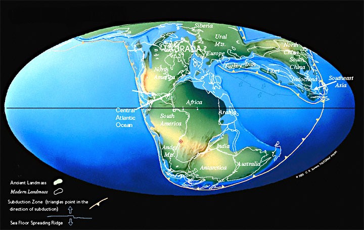
Pangea – o ponto vermelho marca a origem do magma (hot-spot). The red spot shows the magma origin (hot-spot)
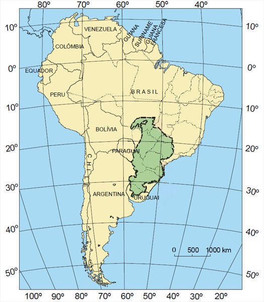
O magma expelido recobriu toda a porção centro-oriental da América do Sul, cobrindo total ou parcialmente os estados brasileiros do Rio Grande do Sul, Santa Catarina, Paraná, São Paulo, Mato Grosso, Mato Grosso do Sul, Goiás e Minas Gerais, além de parte do Uruguai, Argentina e Paraguai e estendendo-se a até o noroeste da Namíbia, criando a Bacia basáltica do Paraná-Etendeka. A área de distribuição do magma de basalto cobriu aproximadamente 1.200.000 km2 com uma espessura média em torno de 700 metros. Treze derrames basálticos consecutivos, com camadas de espessuras entre 15 e 55 metros, ocorreram nos 10 milhões de anos em que o processo esteve ativo. As atuais paredes do cânion assim como todo o planalto que hoje se estende pelo sul do Brasil é o resultado destes derrames conhecido como Paraná Traps e foi a segunda maior ocorrência de grandes derrames de lava basáltica do mundo. O maior derrame registrado até hoje é conhecido como Siberian Traps. O volume total de magma basáltico derramado no Paraná Traps é estimado em 8.600 km3.
The spewing magma covered all the central-eastern portion of South America covering all or part of the Brazilian states of Rio Grande do Sul, Santa Catarina, Paraná, São Paulo, Mato Grosso, Mato Grosso do Sul, Goiás and Minas Gerais, and part of Uruguay, Argentina and Paraguay and extending up to the northwest of Namibia, creating the basaltic basin of the Parana-Etendeka.The range of basaltic magma covered approximately 1,200,000 km2 with an average thickness of around 700 metres. Thirteen consecutive basaltic flows, with layer thicknesses between 15 and 55 metres,occurred within the 10 million years in which the process was active. The current walls of the canyon and all the plateau that covers today southern Brazil is the result of these floods, known as Parana Traps and was the second biggest occurrence lava flows in the world. The largest spill recorded to date is known as the Siberian Traps. The total volume of basaltic magma poured in the Parana Traps is estimated in 8,600 km3.
Paraná Traps
Durante todo o tempo em que o derrame basáltico estava ocorrendo, o super-continente Pangea continuava a se dividir, separando os continentes Sul Americano e Africano que lentamente se afastavam. A separação entre os continentes criou um vale Rift – assim como o que existe atualmente no leste da Africa. As terras baixas do centro do Rift foram tomadas pelo futuro oceano do Atlântico Sul. O local original do hot-spot atualmente se localiza sob o arquipélago de Tristão da Cunha.
During the time the magma flood was occurring, the super-continent Pangea continued to break-up, separating the South American and African continents, which slowly drifted away. The separation between the continents created a Rift Valley – just like the one that currently exists in East Africa. The lowlands in the centre of the Rift were taken by the future South Atlantic Ocean. The original location of the hot-spot is currently located under the islands of Tristan da Cunha.
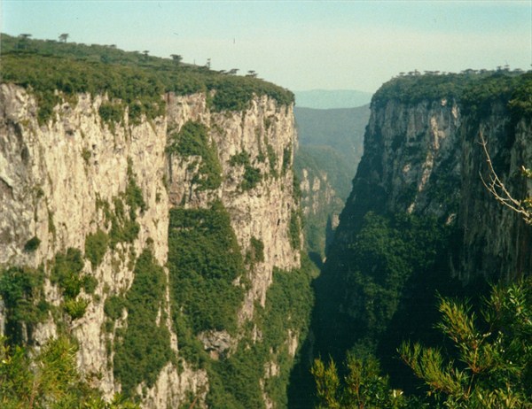
O basalto já solidificado foi partido pela separação dos continentes criando escarpas nos dois lados do futuro Oceano Atlântico e separando as bacias do Paraná e Etendeka. A partir do momento em que o último derramamento de magma cessou e o basalto se solidificou, as forças de erosão começaram a agir. Dois agentes foram e continuam a ser centrais na criação dos cânions que vemos hoje no parque - inclusive no Itaimbezinho – Água e Vegetação.
Um cânion é por definição uma fenda profunda e sinuosa cavada pela erosão de um rio. Os rios que cortam a região passaram a despencar pela borda das escarpas esculpidas pelo basalto e pelo rift do continente. A força constante e cortante da água chocando-se e penetrando nas falhas e fraturas naturais do basalto das escarpas provocou o recuo da escarpa e com o tempo desenvolveu vales em “V” bem fechados – os cânions.
Adicionando-se a força da água, a vegetação da região também contribuiu para o alargamento do cânion. Os derrames basálticos têm limites perfeitamente horizontais caracterizados tanto na base como no topo por superfícies não perfeitamente planas. As camadas dos derrames apresentam nas suas bases e topos fraturas e porosidades que possibilitam a acumulação de água e consequente instalação de uma vegetação arbustiva ao longo da linha de contato. Esta vegetação lança raízes entre as camadas e lentamente enfraquece as rochas, facilitando a ação da água.
The solidified basalt was sliced by the separation of the continents, creating cliffs on both sides of the future Atlantic Ocean and separating the basins of the Paraná and Etendeka. From the moment the last flood ceased and the basalt magma solidified, the forces of erosion began to act. Two agents have been and continue to be central in the creation of the canyons we see today in the park - including Itaimbezinho - Water and Vegetation.
A canyon is by definition a deep and meandering fissure carved by the erosion of a river. The rivers that cross the region began to fall over the edge of the basalt cliffs carved by the continental rift. The waters’s constant cutting force splashing and flowing into natural faults and fractures of the basalt escarpment caused its recess over time developing tightly closed “V” shaped valleys - the canyons.
Added to the water power, the vegetation of the region also contributed to the widening of the canyon. The basaltic flows have perfectly horizontal limits characterized by not perfectly flat top and botton surfaces. Both bottom and top surfaces present fractures and porosities that allow water accumulation and subsequent installation of shrubs along the contact line. This vegetation takes root between the layers limits and slowly weakens the rocks, further facilitating the water action.
O cânion é cercado por duas trilhas que percorrem a sua borda:
Trilha do Vértice: a trilha inicia no centro de visitantes do Parque Nacional dos Aparados da Serra. Em menos de uma hora de caminhada é possível alcançar a borda do cânion Itaimbezinho, chegando até a queda da cascata Andorinhas. O EarthCache e o ponto P1 fazem parte desta trilha.
Trilha do Cotovelo: uma trilha leve de, aproximadamente, 6,3 quilômetros. Esta trilha leva até um mirante que proporciona uma visão geral do cânion. O ponto P2 faz parte desta trilha.
O parque está aberto de quarta a domingo das 09h às 17h. Atenção: é proibido acampar, acender fogueira, fazer travessias e levar animais de estimação nos parques
Curiosidade - a parte superior do cânion até um metro abaixo da borda pertence ao estado do Rio Grande do Sul, enquanto a parte de baixo da parede a partir de um metro do cânion pertence ao estado de Santa Catarina.
The canyon is surrounded by two trails that border its edges:
Vértice Trail: The trail starts at the Aparados da Serra National Park visitors center. I n less than an hour's walk you can reach the edge of the Itaimbezinho canyon, going up to the Andorinhas waterfall. The EarthCache and P1 point are part of this trail.
Cotovelo Trail: a light trail of approximately 6.3 km. This trail leads to a lookout point that provides an overview of the canyon. The point P2 is part of this trail.
The park is open from Wednesday to Sunday from 09am to 5pm.Caution: It is forbidden to camp, make fires, hike and bring pets to the park.
Trivia – The top of the canyon up to one meter below the edge belongs to the state of Rio Grande do Sul, while from the bottom of the wall to up one metre from the canyon’s top belongs to the state of Santa Catarina.
Itaimbezinho Canyon