This spot is an artesian well located at an intersection near the
Mont Alto Penn State campus. The best reason to come here, is the
easy access to the artesian well. To log this cache, you must 1)
log the temperature of the water (so bring a thermometer), 2)
estimate the clarity of the water (is it clear or cloudy) and, 3)
using a container of known size and a timer, record the flow rate
of the well in gallons per minute and email to me. A picture of the
find is encouraged but not required. Drinking water used to be so
easy: Get a cup, find a tap, fill with water, drink, repeat. But
these days even something so simple as water can get complicated.
You may ask yourself: "Am I on well or city water? If I’m on
city water, does it meet FDA guidelines, and are the FDA guidelines
regarding chlorine and arsenic acceptible? Maybe just to be safe
I’ll get a Brita filter, or perhaps something more exotic -
and expensive - involving reverse osmosis? Or how about bottled
water? But bottled from where, and what kind? Spring? Sparkling?
Mineral? How will I know if it’s potable? Does the FDA
regulate bottled water?" And you may say to yourself, "Where can I
get really good water?" Here is your answer.
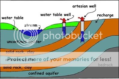
An artesian well allows water to rise to the surface that has
traveled through porous rock from a higher elevation. This pumpless
well seems to defy gravity because the pressure that builds up
between layers of rock gets relieved when the water finds a path to
the open air. For nearly a thousand years, people have drilled
wells to drink such cold, filtered water that doesn't need to be
hauled up from the depths.
An aquifer provides the water source for an artesian well. An
aquifer is the layer of permeable rock, like limestone or
sandstone, that absorbs water from an inlet path at high elevation
such as the top of a mountain. The water source might be fed by
snowmelt or precipitation. Porous stone is sandwiched between a top
and bottom layer of an impermeable substance like clay soil or
shale rock. This keeps the water pressure high, so that when you
get to a point below the entryway of the flow, there is enough
pressure to bring the water up. Natural springs form in the same
way when a gap in the impermeable rock, maybe triggered by an
earthquake, allows the water to rise to the surface.
Entire cities have relied on giant underground aquifers to
provide fresh, cold water when there are no above-ground rivers. In
1126, monks used a rod with a sharp end, called a bore, to
penetrate a layer of impermeable rock. Their percussive drilling,
just hammering on the end of the bore, broke through with sheer
human force. The water that rose had percolated through the pores
of the rock, so that many contaminants have been filtered out, and
it proved safer to drink than standing or river water.
Nowadays, if a town or residence needs water closer to the top
of a mountain, they might lie above the line where there is enough
pressure to push the water all the way to the surface. In this
case, the aquifer can be accessed by drilling a relatively shallow
well and then pumping the water up to ground level. Our
well-drilling has progressed from hammers and bores, to machinery
that twists a giant drill into the ground. Sometimes, if the
pressure is especially strong, because the well is lower in
elevation, the water might thrust up like a fountain, and form a
geyser.
The primary sources of usable water is Pennsylvania include
rainwater , stream inflow from other states, surface water (stored
in lakes, streams, and ponds), and groundwater. In 1966, it was
estimated that Pennsylvanians use approximately 6.6 billion gallons
of water per day and there is approximately 80 trillion gallons of
groundwater and only 2.5 trillion gallons of surface water (DCNR,
Educational Series 3: " The Geology of Pennsylvania's Groudwater").
Below the freshwater aquifer, the bedrock contains salt or brine
water. This brine water is likely water that was trapped in the
formation or material during deposition.
Because of the rural nature of Pennsylvania, groundwater
provides approximately 85 percent of the water used for human
consumption, but because it is difficult to see how water moves
through the soil, unconsolidated material (sand and gravel) and
bedrock, it has mystified individuals. For some homeowners, they
believe that the groundwater comes from a vast underground lake or
from underground streams that come from Canada, Virginia, Vermont,
or even Maine. Even through there is a large database of
information on groundwater in Pennsylvania, it still is difficult
to really document the total available resource and actual movement
and quantity without implementing a very elaborate system of
monitoring wells, observation points, and background water quality
data.
Groundwater is stored in the voids, spaces and cracks between
particles of soil, sand, gravel, rock or other materials. These
cracks or space can include fractures, faults, bedding planes,
solution channels (limestone formations), dissolution channels
associated with more easily weathered material or other structural
features such as bed planes or deformation in the bedrock due to
folding. These materials form what is sometimes called the
groundwater aquifer or reservoir. In most areas of the world, and
specifically in Pennsylvania, water does not flow in and is not
stored in large underground lakes or rivers. The only exception to
this might be the dissolution channels and caverns associated with
limestone formations, abandon mining sites, and mine shafts
associated with underground mining operations.
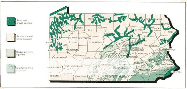
The types of aquifers in Pennsylvania include: unconsolidated
(sand and gravel deposits), sandstone, carbonate, and crystalline
rock. The major water bearing aquifers in Pennsylvania are
associated with sandstone and shale or sedimentary rock units.
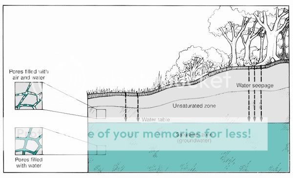
Near surface the material can be divided into the unsaturated or
saturated zone. Recently, the unsaturated zone has been termed to
vadose zone to make it clear that the material may at times be
saturated. Water in the vadose zone can move via saturated and
unsaturated conditions. Under saturated conditions, the
gravitational potential or gravity is the driving force, but under
unsaturated conditions osmotic and matric forces are major
influence.
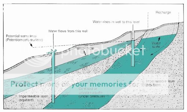
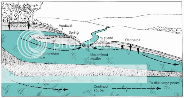
The figure depicts the potential relationship between a recharge
area and a discharge zone and the influence of an aquitard. Figure
7 shows that at some point in the landscape the aquifer is exposed
near the surface. Recharge enters that aquifer, but in some cases
an aquitard, i.e., a formation with a permeability that is at least
10 times, lower than the aquifer acts as a confining layer. This
confining layer causes the water to be directed downslope and
causes pressure to "build-up" in the confined aquifer. If there is
a fracture or weakness in the confining layer, the water will move
up from the deeper groundwater zone and discharge to the surface or
shallow groundwater aquifer.
To understand how we can remove groundwater using wells, we must
understand how groundwater moves. Some people attempt to associate
the flow of water on the earth's surface with groundwater movement.
Surface water flows in rivers or streams at velocities of 2-8 miles
per hour. Pennsylvania's groundwater moves through the spaces
between particles of a saturated material at rates between 0.1 foot
per day to 3 feet per day. That translates into movement of 35 to
1,100 feet per year.
Groundwater moves only if sufficient pressure, or head, is
available to force water through the spaces between porous aquifer
materials. Rate of movement is determined by the hydraulic
gradient, permeability, and porosity of the material. The hydraulic
gradient, or slope of the water surface between two points in an
aquifer, and the aquifer material determines how rapidly water
moves from one location to another.
Groundwater moves from high water surface elevations (high
pressure or head) to low water surface elevations (low pressure or
head). In general, the water flows more rapidly where large
differences exist in water surface elevations (steep hydraulic
gradients), but this is not always the case. A large variation in
the hydraulic gradient could also mean an lower permeability
formation. Groundwater may move toward or away from streams or
lakes, depending on the hydraulic gradient. As groundwater moves it
may be removed by a pumping well, or it may be discharged to the
earth's surface as a spring, a lake or stream. Groundwater supplies
are recharged by precipitation or from rivers and lakes.
Groundwater removed by wells or discharged by springs may have been
stored for thousands of years, or may have entered the aquifer
quite recently.
Under natural conditions, a balance exists between the volume of
water entering an aquifer and the volume of water being discharged
from an aquifer. Under natural conditions, the water is discharged
from the aquifer through evapotranspiration, seepages, streamflow,
and direct discharge to bays/oceans. With the development of water
wells, the natural balance between recharge rates and discharge
rates is disrupted and an artificial groundwater discharge zone is
created when water is extracted from the ground. As long as the
artificial discharge is balanced by enhanced recharge at the
surface, such as the use of on-site well and septic systems,
facilitated or induced stormwater recharge, or large volume treated
effluent recharge systems, the water cycle stays near balanced. If
these additional man-made or influence recharge systems are
established, the result of over-pumping or over-withdrawing water
from the aquifer could cause low baseflows in streams, warmer
streams, less aquatic habitat, high storm or peak flows in streams
because of more runoff, and potential failure of the groundwater
system because of settling of an unconsolidated formation or
induced contamination because of over-pumping.
A local geocacher informed me that this well has had possible
contamination problems in the past due to nitrates and or E. coli.
Due to this, I would advise not to drink from this well.
Come to the coordinates, enjoy the area, answer the questions
and email to me for credit for the find.