Specifics
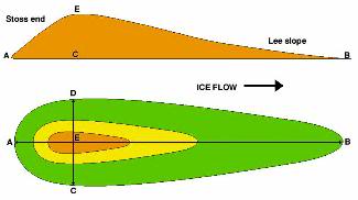
The word “Drumlin” is derived from the Gaelic word “druim” meaning “rounded hill” or “mound”. Drumlins are described as elongated hills in the shape of half-buried eggs or inverted spoons. They are typically up to 2 km long, less than 50m in height, between 300 and 600m in width and roughly symmetrical around their long axis. They generally have a consistent ratio of 2 to 3.5, width to length dimension and are often found in clusters, called “Swarms”, of similarly shaped, sized and oriented hills. These clusters can disrupt drainage so that small lakes and/or swamps may form around or between them. They most often contain layers of varying sized rock (glacial till) indicating that material was repeatedly added to the core over time, a process called stratification.
Formation
There is still debate on how Drumlins were originally formed. The most widely accepted theory states that when the ice flow becomes overloaded with sediment, reducing the competence of the ice, deposition occurs. Sediment deposition occurs much in the same manner that an overloaded river deposits its excess sediment. An ice flow could experience a reduction of competence by means of melt-off or by changes in the velocity of its movement, among other things. Another belief states that an obstacle at ground level, possibly a bedrock outcrop, acts as a barrier, causing glacial till to accumulate around the protrusion as the glacier passes around and over it. It is believed that this second process was responsible for the creation of the Drumlin located here. It’s difficult to understand how the material could have been directly deposited in the characteristic shape of a Drumlin, unless the ice was still moving at the time of deposition. Further ice movement may also have reshaped the Drumlin after it was originally deposited. The origins of Drumlins may be the most studied surface type geologic landform in the Northern Hemisphere.
The Test
This is a drive-by EarthCache. No need to even leave your automobile to collect the information needed. The given coordinates will bring you onto a county road. The Drumlin lies off to the East of this road. The coordinates given will put you on this road, parallel to one end of the Drumlin. Which end it is, is for you to figure out. You will have to drive one way……….or the other, along this county road until you reach a point parellel to what you believe is the opposite end of the Drumlin and take an overall length reading. You will also have to figure out which end is the Stoss slope end and which is the Lee slope end. Also tell me in what direction the ice flow was taking when this Drumlin was formed.
#1. Overall length of Drumlin?
#2. Which end is the Stoss end?
#3. Direction of ice flow?
Email your answers to the questions, to me, using the link in my profile only. If the answers are not recieved, your log will be deleted. You do not have to wait for confirmation from me before logging this cache as completed. Photos are accepted and appreciated as long as the answers to the questions are not revealed. Most of all……Learn……and enjoy the view.