Mays Ledges are a series of rapids on the Brule River north of the town of Brule. They are one of our favorite spots to go when we travel to Brule to take pictures and to enjoy the scenery.
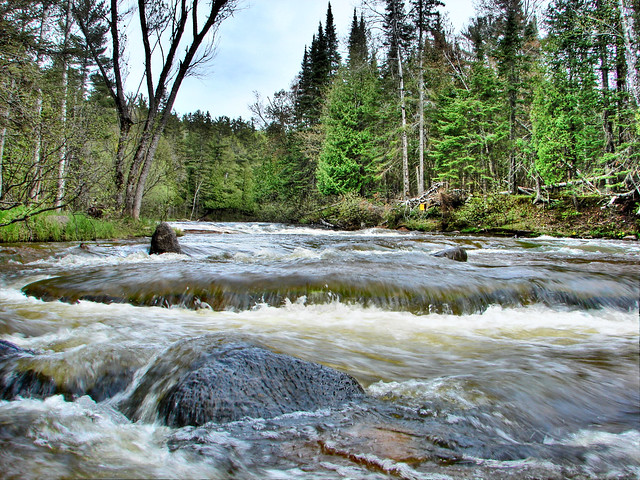
Mays ledges have been classified as class 3 rapids. They are incredibly beautiful and powerful. Yet they are not what you going there to see. You are going to see what the ledges have done to their surroundings.
The Brule River formed when the last glaciers receded from the Superior Area. The bed of the Brule River was carved by melting glacial water as it flowed across the landscape. The receding water washed away dirt and soil but some bedrock was just too hard to cut through. The place you are going is one of those places.
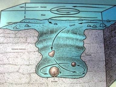
This large boulder has been sculpted and changed over eons of rushing water. One of the many changes brought on by the water was formations called Geological Potholes. Potholes commonly form in the rough parts of the river (such as Mays Ledges.) The rock that is potholed generally stands as a barrier in the way of the onrushing water. In areas like Mays Ledges, the force behind the water is strong enough to push the water up and over the rock. When the water is forced over the still standing bedrock, a spinning effect, or an eddie is created. As the water spins it creates a shallow cavity in which water continues to gather. As small rocks and debris flow with the water over the boulder, the pothole is further eroded into the rock. In some instances these holes may be a couple feet deep. In the case of this large boulder, many potholes have been formed over the life of the Brule River and new potholes continue to be formed.
1) How many Potholes do you see in the rock? (May differ depending on the water levels)
2) How deep are some of the holes? (Measure with a ruler or a stick and then measure the stick)
3) What is the biggest diameter pothole that you can find?
Used information from http://stateparks.us-parks.com and http://thebritishgeographer.weebly.com/river-landforms.html
Please Email us the answers to the questions via my profile page. DO NOT POST THE ANSWERS IN YOUR LOG!
Place with permission from the Wisconsin DNR and the Brule State Forest.
Enjoy your time at Mays Ledges!
