There is no absolutely no need to leave the trails to get the information for this earthcache. Obey all the park rules, be safe, and enjoy your visit!
Vancouver Island was formed through a combination of processes, including tectonic plate movement, volcanism, erosion and glaciation. Between 29,000 and 15,000 years ago, the most recent glacial period or ice age developed and is now referred to as the Fraser Glaciation. Ice accumulated on the mountain peaks of Vancouver Island and slowly grew into large glaciers. Eventually they joined with other glaciers and formed ice sheets that filled the major valleys. Between 15,000 years before present and today, the climate began to warm and the ice sheets slowly melted and retreated. The release of the weight of ice caused the land to rebound. This exposed areas of land that were previously submerged. For about a thousand years, around 10,000 years ago, the rate of rebounding from the land exceeded the sea level rise caused by the melting glaciers. Eventually the sea reclaimed some of the recently exposed land, and stabilized at its current level. In place of the ice sheets, large deposits of glacial till were left. This was formed from rock that was ground up under the ice sheets, deposited on the surface of the glaciers, or pushed up in front of advancing glaciers.
Lakes, streams and rivers formed from melting ice, and rivers transported glacial sediment to new locations. Rivers and streams are not only movers of water, but also of sediment. The water, as it flows over the channel bed, is able to mobilize sediment and transport it downstream, either as bed load, suspended load or dissolved load. The rate of sediment transport depends on the availability of sediment itself and on the rate of the river's discharge. Sediments generally consist of well-compacted material that contains a mixture of particle sizes. It commonly comprises a mixture of sand, silt, and clay that has been transported beneath, beside, on, within, and in front of a glacier and not modified by any intermediate agent.
Pot holes are cavities or holes which appear to have been drilled in the surrounding rocks by eddying currents of water-bearing stones, gravel and other diverse matter. The size varies from a few inches to several feet in depth and diameter. The most common occurrence is in shields, where there are ancient rocks (granite, gneiss) with different resistance to erosion, so strong pebbles fall in a small cavity and swirl making this cavity wider and deeper. In areas where there are diamonds and quartz rocks, the hardness of these rocks cave pot holes and sometimes remain trapped in the bottom of it. Hardness of pebbles must be the same or higher than the bottom of stream where the pothole is forming. Some holes are made within river beds at the foot of cascades, and under some other circumstances.
To log this cache please email me the following information through my geocaching.com account. Once you've sent your answers in, go ahead and log your find without waiting for a reply from me. I will contact you if there is a problem with your log entry. Please do not post your answers with your log!
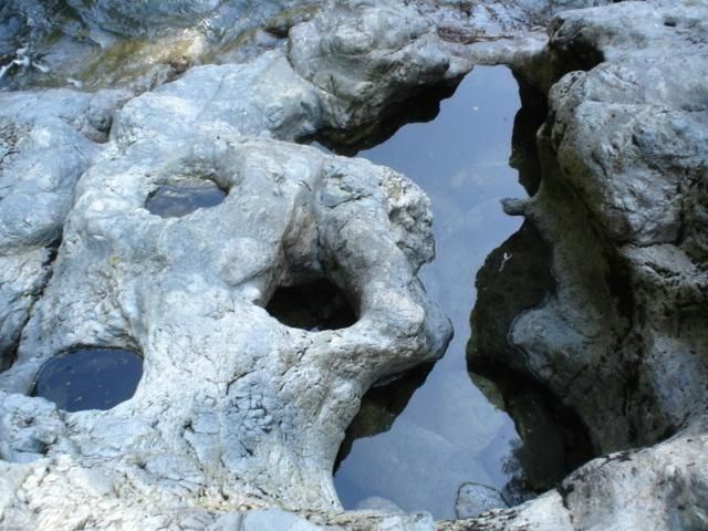
1) From the listed coordinates, (N48 26.232 W123 43.004) at the view point, you will see several pot holes in the exposed rock bed below the viewpoint. One area has several pot holes that have eroded over time and are now joined together. It looks like an animal has been carved in the stone.
How many pot holes are directly
i) below this?
ii) beside this?
iii) above this?
2) How do you think these pot holes formed, and what evidence did you use to come to this conclusion?
3) What is your estimate the average diameter of the pot holes you can see from the viewpoint?
4) The gouges and lines in the rock below run in which direction?
Glossary:
Volcanism
Volcanic activity
Dissolved Load
Dissolved matter is invisible, and is transported in the form of chemical ions (atoms or molecules). All stream carry some type of dissolved load. This type of load can result from mineral alteration from chemical erosion, or may even be the result of ground water seepage into the stream.. Materials comprising the dissolved load have the smallest particle size of the three load types.
Suspended Load
Suspended load is made up of fine sediment particles suspended and transported through the stream. These materials are too large to be dissolved, but too small to lie on the stream bed,. Stream flow keeps these materials such as clay and silt, from settling on the stream bed. Suspended load is the result of material eroded by hydraulic action at the stream surface bordering the channel as well a erosion of the channel itself. Suspended load accounts for the largest majority of stream load.
Bed Load
Bed load rolls slowly along the floor of the stream. This includes the largest and heaviest materials in the stream, ranging from sand and gravel to cobbles and boulders. There are two main ways to transport bed load:Traction and saltation. Traction describes the "scooting and rolling" of particles along the bed. In stream load transport, saltation is a bounce-like movement, occurring when large particles are suspended in the stream for a short distance after which they fall to the bed, dislodging particles from the bed, The dislodged particles move downstream a short distance where they fall to the bed, again loosening bed load particles upon impact.
Rivers Discharge
The discharge of a river is the volume of water which flows through it in a given time. It is usually measured in cubic meters per second. The volume of discharge will be determined by factors such as climate, vegetation, drainage basin relief and the activities of man.