TFGT: Flight Span Traditional Geocache
-
Difficulty:
-

-
Terrain:
-
Size:  (small)
Please note Use of geocaching.com services is subject to the terms and conditions
in our disclaimer.
You do NOT need to go off trail access this cache. No bushwhacking please! The cache is accessible from the trail.
Anyone can claim this cache, but to be eligible for the Taking Flight Geo Tag you use the measuring tape and chart inside of the cache to determine your "wingspan." Take a look at the wingspans for the different types of native Florida birds. Which one are you closest to in feet and inches? Be sure to write your "wingspan," and the bird that is closest, in your passbook.
Stretch out your arms wide and look from fingertip to fingertip. This is your arm span. In birds, this is called the wingspan – the total length of the bird’s wings, measured between the tips of the primary feathers on each wing when the wings are fully extended. Each bird’s wing shape is unique to its particular type of flight; the wingspan will help determine the birds’ most common type of flight. Birds that have fast flight and dive, like falcons, have short wings that taper to points and are built to allow for rapid wing beats and high speed. Some birds have elliptical wings that are short and rounded allowing for tight maneuvering in confined spaces like tree-filled forests. The accipiter hawks, a predator who hunts birds in the trees, is known for this type of wing. Birds that soar for long periods of time, such as albatrosses and other seabirds, have longer wings built for “dynamic soaring”. Their wings can utilize different wind speeds at different heights above the waves in the ocean to provide lift. Still other birds have wings that allow for hovering, such as kingfishers and hummingbirds. By studying the wingspan and overall wing shape of the bird we can learn a great deal about the flight mechanics of each individual species.
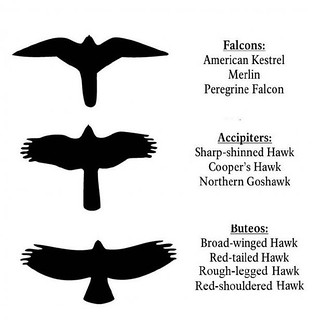
Flight silhouettes
Ungarelli Preserve is now open to the public! Newly opened in March 2016, this coastal gem is now open to explore. When the land was acquired, there was a great deal of trash and exotic invasive plants at the site and the Natural Resources Department has worked hard in order to restore the site back to a more natural environment. Already, a wide variety of birds have been spotted at the site including red bellied woodpeckers, red-shouldered hawks, brown pelicans, killdeers, turkey vultures, white ibises, ospreys, grackles, roseate spoonbills, American crows, tri-colored and great blue herons. With the restoration of the site and the improvement of the habitat, birds have flocked to the site. Many of the birds that are seen here are “fly-overs” as the birds move from one part of Ungarelli to another and this is a great opportunity to check out the flight silhouette of the bird, and its wingspan, in order to attempt to identify it.
Anyone can claim this cache, but to be eligible for the Taking Flight Geo Tag you use the measuring tape and chart inside of the cache to determine your "wingspan." Take a look at the wingspans for the different types of native Florida birds. Which one are you closest to in feet and inches? Be sure to write your "wingspan," and the bird that is closest, in your passbook.
Visit the sites along the Taking Flight GeoTour (TFGT) and learn about Manatee County’s wild spaces and the amazing feathered friends that live in them. Along the way, you will be challenged to become a citizen scientist, a preserve ranger, a detective, a historian, and of course an excellent geocacher in order to find all of the caches in the trail. Caches are located in birding “hot spots” throughout Manatee County’s publicly accessible conservation preserves. Each one highlights a specific bird species or aspect of bird life providing you with opportunities to learn more about these creatures and what we can do to help them survive. Caches also focus on protecting the region's waterways, bays, and natural watersheds, and habitat areas for many of our area’s feathered fliers.
The Taking Flight GeoTour includes 20 caches within Manatee County. A custom Taking Flight Geo Tour trackable geo tag will be awarded for locating at least 12 TFGT caches. To be eligible for the tag, geocachers must download a passport from the TFGT Website or pick one up at the Manatee County Natural Parks & Natural Resources Department office at GT Bray Park 5502 33 rd Ave. Dr. W., Bradenton, FL., Monday through Friday, 9 a.m. to 4 p.m. Geocachers must log at least 12 finds, answer the question from each cache on their passport, and complete any additional requirements for specific caches (such as posting photos for earth caches). After finding a minimum of 12 caches, participants can have their passports validated in person or via mail at the Manatee County Natural Parks & Natural Resources Department office at GT Bray Park 5502 33 rd Ave. Dr. W., Bradenton, FL 34209, Monday through Friday, 9 a.m. to 4 p.m. News and updates on tag availability and validation hours can be found online at the Parks & Natural Resources Department's website.
Thank you for assisting with the Taking Flight GeoTour:
Additional Hints
(Decrypt)
Purpx gur plpnq