The Bar That Named a Town EarthCache
The Bar That Named a Town
-
Difficulty:
-

-
Terrain:
-

Size:  (not chosen)
Related Web Page
Please note Use of geocaching.com services is subject to the terms and conditions
in our disclaimer.

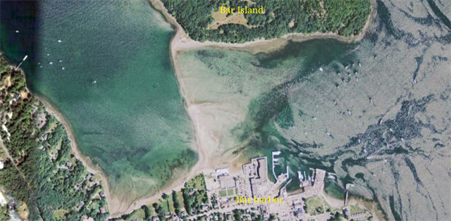
Bar Harbor to Bar Island
A sand and gravel bar, exposed for only couple of hours around low tide, connects Bar Island to Bridge Street in Bar Harbor. At low tide visitors often walk across, or park cars on the exposed bar. However on the island side in front of a locked gate there is only a small grassy area fringed with dense sea rose bushes, elevated enough to be safe for parking when the tide comes in. Visitors have been known to return from a hike to find their cars submerging and themselves stranded until the tide recedes. Please be careful!!
Shoals
A shoal, sandbar, sandbank or gravelbar is a somewhat linear landform within or extending into a body of water, typically composed of sand, silt or small pebbles. A spit or sandspit is a type of shoal. Shoals are characteristically long and narrow and develop where a stream or ocean current promotes deposition of granular material, resulting in localized shallowing (shoaling) of the water. Shoals can appear in the sea, in a lake, or in a river. Alternatively a bar may separate a lake from the sea, as in the case of an ayre. They are typically composed of sand, although could be of any granular matter that the moving water has access to and is capable of shifting around (for example, soil, silt, gravel, cobble, shingle, or even boulders). The grain size of the material comprising a bar is related to the size of the waves or the strength of the currents moving the material, but the availability of material to be worked by waves and currents is also important.
The term bar can apply to landform features spanning a considerable range in size, from a length of a few meters in a small stream to marine depositions stretching for hundreds of kilometers along a coastline, often called barrier islands.
In a nautical sense, a bar is a shoal, similar to a reef: a shallow formation of sand that is a navigation or grounding hazard, with a depth of water of six fathoms 6 fathoms or less. It therefore applies to a silt accumulation that shallows the entrance to the course of a river or creek.
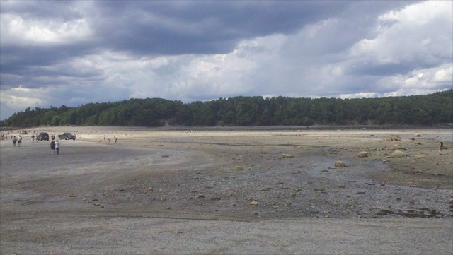
Bar Island in the background
Shoaling
When surface waves move towards shallow water, such as a beach, they slow down, their wave height increases and the distance between waves decreases. This behavior is called shoaling, and the waves are said to shoal. The waves may or may not build to the point where they break, depending on how large they were to begin with, and how steep the slope of the beach is. In particular, waves shoal as they pass over submerged sandbanks or reefs. This can be treacherous for boats and ships. It's good for surfers.
Shoaling can also diffract waves, so the waves change direction. For example, if waves pass over a sloping sandbank which is shallower at one end than the other, then the shoaling effect will result in the waves slowing more at the shallow end. Thus the wave fronts will refract, changing direction like light passing through a prism. Refraction also occurs as waves move towards a beach if the waves come in at an angle to the beach, or if the beach slopes more gradually at one end than the other.
Types of Bars:
Sandbars and Longshore Bars
This bar forms where the waves are breaking, because the breaking waves set up a shoreward current with a compensating counter-current along the bottom. Also known as a trough bar. Sand carried by the offshore moving bottom current is deposited where the current reaches the wave break. Other longshore bars may lie further offshore, representing the break point of even larger waves, or the break point at low tide.
Harbor and River Bars
A harbor or river bar is a sedimentary deposit formed at a harbor entrance or river mouth by the deposition of sediment or the action of waves on the sea floor or adjacent beaches. A bar can form a dangerous obstacle to shipping, preventing access to the river or harbor in unfavorable weather conditions or at some states of the tide. Where beaches are suitably mobile, or the river’s suspended and/or bed loads are large enough, wave action can build up a bar to completely block a river mouth, damming the river, preventing access for boats or shipping, and causing flooding in the lower reaches of the river. This situation will persist until the bar is eroded by the sea, or the dammed river develops sufficient head to break through the bar.
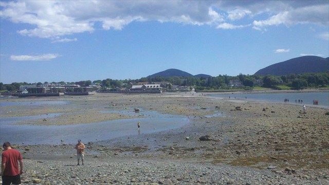
Bar Harbor in the background
Logging Requirements
In an email to the cache owner, please answer the following questions:
1: What time and date did you visit the Earthcache?
2: How many minutes or hours were you there before or after low tide?
3: At the time of your visit, what was the width of the bar, at the bar’s widest point?
4: Do you think this is a "Sandbar/Longshore Bar", or a "Harbor/River Bar"?
5:(This task is optional) Please include a picture of yourself AND/OR your GPS with the either Bar Island, or Bar Harbor in the background.


free counters
free counters
Additional Hints
(No hints available.)