Cache Summary: In the middle of a neighborhood in Houghton, nestled around houses, is a large basaltic outcrop showing evidence of the Scales Creek lava flow dating approximately 1 billion years in age.
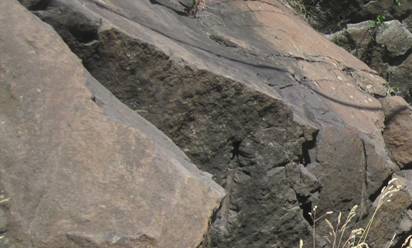 Figure 1. A closeup of the basaltic rock in the scales creek lava flow. Source: photograph taken by K. Luckett
EarthCache Lesson:
How do ancient geological processes affect modern human life?
Driving through the neighborhoods in Houghton you can see many houses built into the side of steeply sloped hills with occasional outcrops of dark colored basalt. These were formed more than 1 billion years ago by a series of lava flows known as the Portage Lake Volcanics. There were approximately 400 lava, that erupted over 2 to 3 million years, originating from cracks or fissures above the once spreading Midcontinent Rift System (see figure two below). As the lavas erupted they flooded the rift basin, covering the areas with flows between 10 and 1200 feet thick. Due to their thickness these flows could take thousands of years to cool.
The Scales Creek flow was one of the Portage Lake lava flows. It was about 200 feet thick and traveled for a distance of at least 20 miles through the Houghton area near Franklin Square. It makes the ridge that many of the houses are built around and the roads have to bend around or be cut through. In some places the roads do not cross it and there are no houses built on this flow.
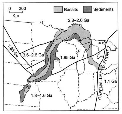
Figure 2. Map showing the basaltic and sedimentary deposits formed by the Midcontinent Rift. These rocks are still exposed today in the Keweenaw Peninsula. Provided by: http://www.geo.msu.edu/geogmich/rift_zone.html
Logging Your Visit:
Logging Question One: Examine the outcrop. Why do thick flows like this make ridges? Use evidence from your observations to provide reasoning.
Logging Question Two: Visit N 47° 7.171’ W 088° 33.762’. How has the Scales Creek flow influenced the construction of the road in this location? Why?
Bonus question: Since building on the basalt is difficult, what other uses could these areas have in the city?
Earth Science Literacy Principles Big Ideas:
BIG IDEA 4. Earth is continuously changing.
Our planet is made up of tectonic plates that are constantly moving around the planet. In the Earth’s history they have done these same processes. Our present location on the Earth has changed and will continue to change as time passes and the plates move. This will allow a different climate and therefore different organisms to live there. The Earth also experiences periodic climate changes (i.e. periods of warming and cooling). These natural cycles allow the Earth to change as well.
Common Earth Science Misconceptions:
All rocks are the same: In the Keweenaw Peninsula, you can see volcanic basalt, conglomerate, and sandstone. These rocks all vary in composition and type.
Basalt, as seen here, is an igneous rock formed from the cooling of basaltic lava exposed at or very near the surface of a planet.
Rock layers are always flat: The rocks seen here have a strike and dip because they are not flat. Rocks can be deposited and then geological processes such as folding, faulting, erosion and uplift can alter the rocks position.
References:
Michigan Rock Deposits. Retrieved July 22nd, 2012 from: http://www.geo.msu.edu/geogmich/rift_zone.html
Rose, Bill. Personal Interview. 28 June 2012.
Rose, Bill. Scales Creek Flow http://www.geo.mtu.edu/~raman/SilverI/HoughtonEC/Scales_Creek.html