 [DEUTSCH]
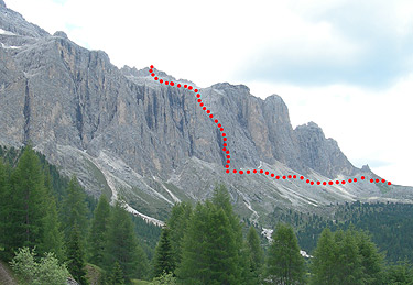
Klettersteig Piz Selva, 2941 m - Pößneckerstieg 6 Std. 750 Hm
Schwierigkeitsgrad : Schwer
Talort: Wolkenstein, 1560 m
Ausgangspunkt: Sellajochhaus, 2176 m
Gehzeiten: Sellajoch - Piz Selva 3 1/2 Std.
Piz Selva - Grödner Joch 2 1/2 Std.
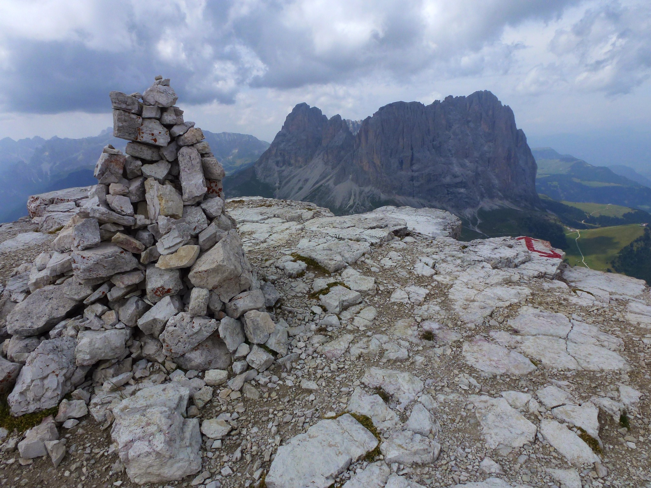
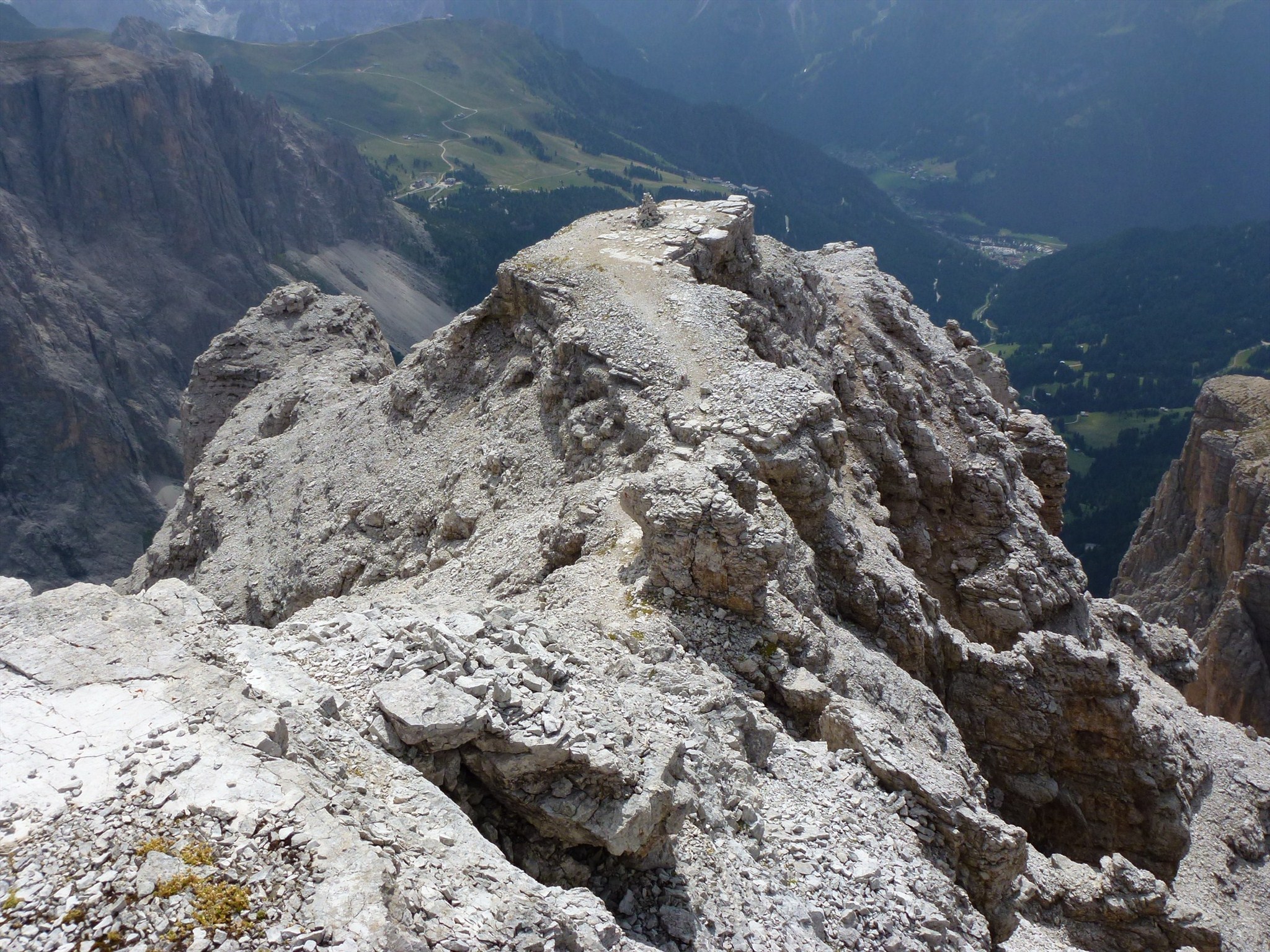
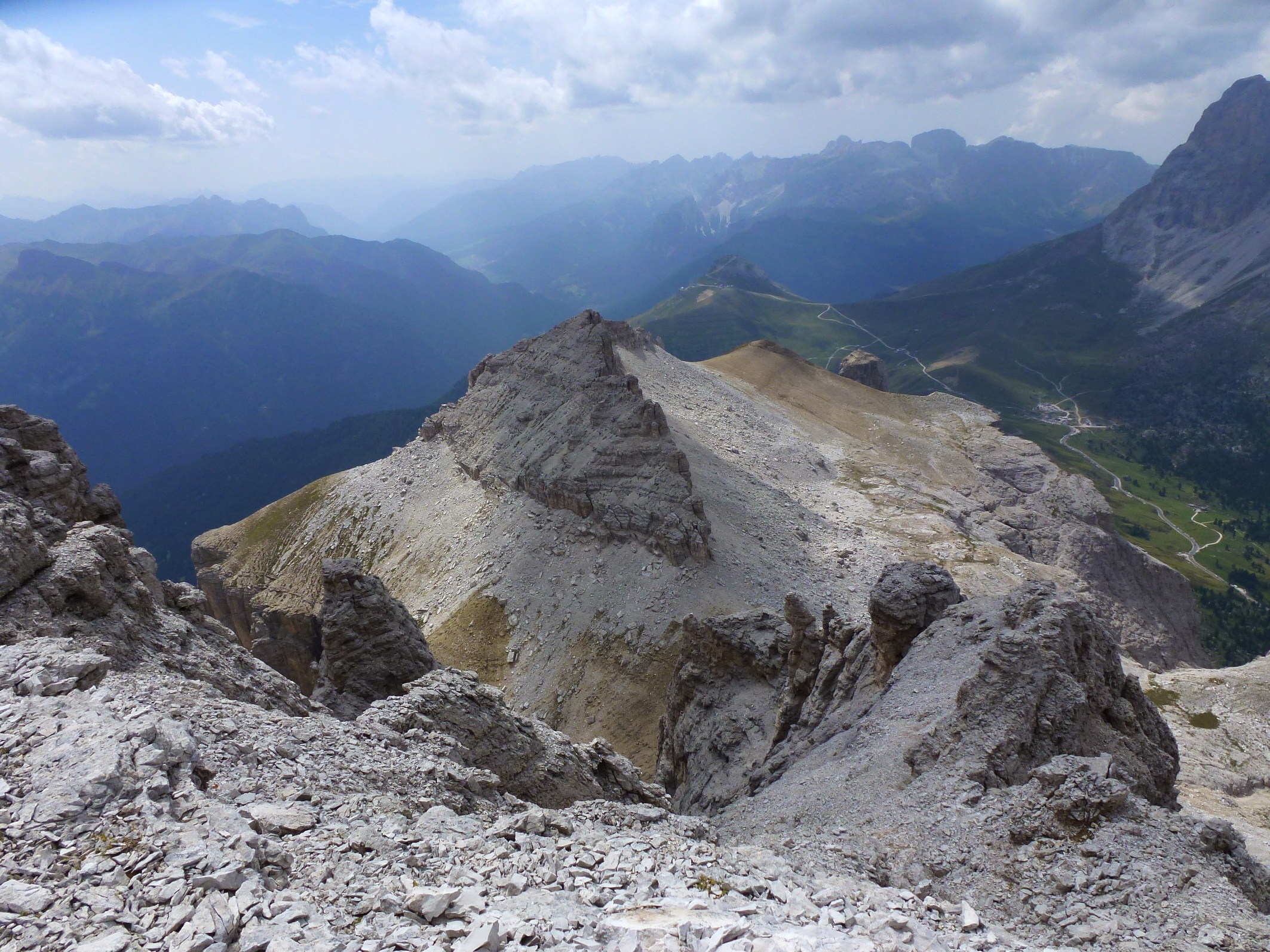
Route: Auf dem Weg Nr. 649 geht es durch Wiesen und über Schutthänge am Westfuß der Sellatürme zu einem kleinen Sattel, dort befindet sich der Klettereinstieg. Eine Leiter führt sie ausgesetzten Wand und mit Hilfe von Drahtseilen und Steighilfen geht es zum Ausstieg. Der Steig der natürlich markiert ist führt Sie zum Sattel. Von dort geht es weiter über einen leichten Klettersteig zum Piz Selva. Nun geht es weiter zu Piz Beguz und zur Gamsscharte. Nun können Sie nördlich durch das Val Ciadin zur mittleren Sellaterrasse und zur Mündung des Val Setus absteigen, der Steig mit der Markierung 666 führt Sie zum Grödner Joch.
Pößnecker Klettersteig (Piz Selva) - Wegbeschreibung
Charakteristik: Der Anstieg des Pößnecker Klettersteigs ist sehr steil und ausgesetzt, vor allem der Ausstieg auf die zweite Leiter ist äußerst exponiert. Armkraft, aber auch gute Technik auf den glatten Felsplatten und im Kamin (nur Eisenklammern, kein Stahlseil) sind unbedingt erforderlich. Eis- und Schneereste können eine Begehung unmöglich machen. Insgesamt sehr lange und anspruchsvolle Tour, die eine gute Portion an alpiner Erfahrung voraussetzt. Zum Teil lange Seilabstände zwischen den einzelnen Verankerungen. Achtung: Das Stahlseil ist zudem an einigen Stellen sehr locker verspannt! Schwierigkeit: Anstieg über zum Teil sehr glatten Fels. Durch nordwestliche Ausrichtung halten sich Schnee und Nässe auf diesem Anstieg sehr lange; oft kalt und vereist. Sehr langer Abstieg. Zugang: Vom Kiosk (siehe Ausgangspunkt) über einen guten Steig mit der Markierung 649 unter den Sellatürmen hindurch zum Einstieg. Technische Details: Sehr alpiner Klettersteig über glatten Fels, Steilpassagen durch Leitern und künstliche Tritte (Eisenbügel und Stifte) etwas entschärft. Zum Großteil sehr steiler und auch exponierter Anstieg, Armkraft und gute Tritttechnik erforderlich. Detailstrecken am Klettersteig: 80 % Stahlseil, 4 % Leitern, 8 % Eisenbügel, 8 % exponierter Pfad. Gesamter Aufstieg: 700 hm, 3:30 Std. Zustieg: 50 hm, 0:30 Std. Klettersteig: 250 hm, 1:30 Std. Ausstieg – Piz Selva: 400 hm, 1:30 Std. Vom Ausstieg weiter auf gut sichtbaren Steigspuren, nochmals kurze Stahlseilsicherung, dann auf markiertem Steig zur oberen Schuttterrasse bzw. in den Sattel zwischen Piz Ciavazes und Piz Selva. Nach links und wiederum gesichert zum Piz Selva. Abstieg: Vom Gipfel führen markierte Steigspuren zum großen Gipfelkreuz am Piz Miara. Weiter abwärts in die Forcela dei Ciamorces (Gamsscharte), 2923 m, und in die Sela de Pisciadù. Rechts ab über Weg Nr. 649 und in den Dolomiten Höhenweg Nr. 2 bis zur Weggabelung, dort Weg Nr. 647 einschlagen. Über diesen durch das Val Lasties bis zur nächsten Wegkreuzung. Dort den Weg Nr. 656 bis zur Kehre der Sellajochstraße benutzen. auf der Straße zurück zumSellajoch (Gegenanstieg). Insgesamt 4:00 Std. Ausrichtung: Nordwest.
 [ITALIANO]
Alpina L'accesso a questa via ferrata è corto e facile, salita ripida ed estremamente alpina, con discesa molto lunga. Si consiglia l'ascensione solo in periodi asciutti e in condizioni di tempo decisamente buone. In primavera attenzione ai residui di neve e ghiaccio. Al mattino la ferrata resta a lungo in ombra. Alcuni brevi tratti non assicurati richiedono un'assoluta sicurezza di passo. In caso di scarsa visibilità l'orientamento sul pianoro sommitale può diventare problematico.
Via ferrata Mesules, Piz Selva - Itinerario
Caratteristiche della via ferrata: salita molto ripida ed esposta; lo è in particolare l'uscita sulla seconda scala. L'arrampicata richiede assolutamente una gran forza di braccia, ma anche una buona tecnica di salita sulle placche lisce e nel camino (solo gradini metallici, niente cavo d'acciaio). La salita può essere resa impossibile dalla presenza di resti di neve o ghiaccio. L'escursione è complessivamente molto lunga e impegnativa e richiede una buona esperienza alpinistica. A volte la distanza tra fittoni dei cavi dacciaio è notevole. Attenzione: il cavo metallico in certi punti è pure poco teso.
Difficoltà: salita su roccia in parte molto liscia. Per sua esposizione a nord-ovest, la via ferrata resta a lungo innevata e bagnata; è spesso fredda e ghiacciata. Discesa molto lunga.
Accesso alla ferrata: dal chiosco si raggiunge l'attacco della via ferrata seguendo il segnavia 649, sotto le torri del Sella.
Particolari tecnici: via ferrata decisamente alpina, che si sviluppa lungo roccia liscia; i passaggi più ripidi si superano su scale e infissi artificiali (staffe e pioli). La salita è in gran parte molto ripida e anche esposta e richiede forza di braccia e buona tecnica di piede
Tipologia del percorso: 80% cavo dacciaio, 4% scale, 8% staffe di ferro, 8% sentiero esposto.
Dislivello complessivo in salita: 700 m, 3:30 ore.
Dislivello fino all'attacco della ferrata: 50 m, 0:30 ora.
Dislivello ferrata: 250 m, 1:30 ore.
Uscita Piz Selva: 400 m, 1:30 ore. All'uscita si prende la traccia ben visibile, si passa nuovamente per un breve tratto assicurato con corda d'acciaio e poi, lungo il sentiero segnato, si raggiunge la terrazza detritica e quindi la forcella tra il Piz Ciavazes e il Piz Selva. Si prende a sinistra e si ritorna, nuovamente assicurati, al Piz Selva
Discesa: dalla cima delle tracce di sentiero segnato portano alla gran croce di vetta del Piz Miara. Più in basso alla Forcela dei Ciamorces (Forcella dei camosci, 2923 m) e alla Sella del Pisciadù. Si scende a destra sul sentiero n. 649 e sulla Alta via n. 2 delle Dolomiti fino al bivio; da lì si prosegue sul sentiero n. 647 e si attraversa la Val Lasties fino ad arrivare al prossimo punto d'incrocio. Il percorso prosegue lungo il sentiero n. 656 fino al tornante della strada che porta al Passo Sella. Su questa si ritorna al passo (salita). In totale 4 ore.
 [ENGLISH]
Alpine Access to this via ferrata is short and easy, and extremely steep climb alpine downhill with very long. It is recommended that the climb only in dry periods and in very good weather conditions. In spring attention to the residues of snow and ice. In the morning the strike remains a long time in the shade. Some short uninsured require absolute safety of pace. In case of poor visibility on the summit plateau orientation can be problematic.
Via ferrata Mesules, Piz Selva - Itinerary
Features of the via ferrata climb very steep and exposed, it is in particular the exit on the second scale. Climbing requires a very large force of arms, but also a good technique to climb on smooth slabs and fireplace (only metal stairs, no steel cable). The ascent can be made impossible by the presence of remnants of snow or ice. The excursion is generally very long and demanding and requires a good mountaineering experience. Sometimes the distance between taproots of cables dacciaio is remarkable. Warning: the wire in some places is also little tense.
Difficulty: rock climbing in the very smooth. By its exposure to the north-west, the railway remains a long snowy and wet, it is often cold and icy. Downhill very long.
Access to railway: from the kiosk you reach the attack of the via ferrata following the trail 649, beneath the towers of Sella.
Technical details: via ferrata decidedly alpine, which runs along smooth rock, the steps are steeper than on artificial scales and fixtures (brackets and pegs). The ascent is mostly very steep and also exposed and requires strength of arms and good technique of foot
Type of trail: 80% dacciaio cable, 4% stairs, 8% iron stirrups, 8% path exposed.
Total uphill altitude difference: 700 m, 3:30 hours.
Difference in altitude up to the attack of the ferrata: 50 m, 0:30 hours.
Difference in altitude climbing: 250 m, 1:30 hours.
Output Piz Selva: 400 m, 1:30 hours. Exit, take the track visible, you switch back to a short stretch secured with steel rope and then along the marked path, you reach the terrace debris and then the fork Ciavazes between Piz and Piz Selva. Turn left and return, again be sure, Piz Selva
Descent from the summit of the tracks marked trail leading to the summit of the Grand Cross of Piz Miara. Further down the Forcela of Ciamorces (Fork of the chamois, 2923 m) and the Sella Pisciadù. Go down to the right along trail. 649 and the Alta Via n. 2 of the Dolomites to the junction, and from there continue on the path n. 647 and cross the Val Lasties up to the next crossroads. The route continues along the path n. 656 up to the bend in the road that leads to Passo Sella. On this return to step (rise). In total 4 hours.