The Green Path: Trekkking and Biking Trail Traditional Geocache
The Green Path: Trekkking and Biking Trail
-
Difficulty:
-

-
Terrain:
-

Size:  (micro)
Please note Use of geocaching.com services is subject to the terms and conditions
in our disclaimer.
DE:
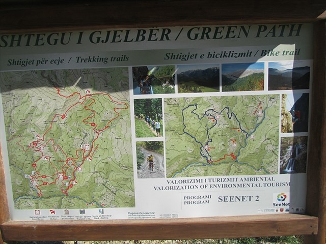
Der Grüne Pfad ist eine Gegend im hinteren Teil des Rugova Tal, welche aus verschiedenen Trekking Trails und einem Bike Trail besteht. Am beginn des Pfades kann man direkt ein Touristenfreundliches Schild finden und sich einen Überblick verschaffen. Es gibt mehrere Kletterpunkte, Gasthäuser, ein Museum und auch einen Wasserfall, in dessen Nähe sich der Cache befindet.
Um den Cache zu finden, fahrt weiter bis zum Parkplatz und nehmt dort den kleinen Pfad, der über ein paar Brücken in den Wald führt. Ganz am Ende findet ihr einen Wasserfall. Der Cache befindet sich rechts von Wasserfall. Um ihn zu finden, müsste ihr den sandigen Berg ein paar Meter nach oben steigen und an der Felswand schauen. Unterschätzt den kleinen Berg nicht. Durch den Sand hat man keinen guten Halt. Sowohl der Auf-, als auch der Abstieg können schnell in einer Rutschpartie enden.
Schaut nicht zu sehr auf die Koordinaten, auf Grund der örtlichen Begebenheiten ist die GPS-Genauigkeit gerade mal bei 35 metern gewesen.
EN:
The Green Path is located almost at the end of the Rugova Gorge and consists of different Trekking Trails and a Bike Trail. At the beginning of the path you can find a sign for tourists to give you an overview of the area. You can find some rock climbing points, guest houses, a museum and a waterfall, where the cache is hidden.
To find the cache you have to drive further to the parking spot and take the small path over some bridges into the wood. At the end you'll find a waterfall. The cache is located on the right of the waterfall. To find it you have to climb the sandy hill a few meters and look at the rock wall. Don't undervalue the hill. Because of the send there's not much grip and the way up as well as the way down can end as a glissade.
Don't look too much for the coords because my gps-accuracy was only 35 meters because of the rocks.
Additional Hints
(Decrypt)
HCF