Walsheimer Duppstein EarthCache
-
Difficulty:
-

-
Terrain:
-

Size:  (not chosen)
Please note Use of geocaching.com services is subject to the terms and conditions
in our disclaimer.
Der Walsheimer "Duppstein"
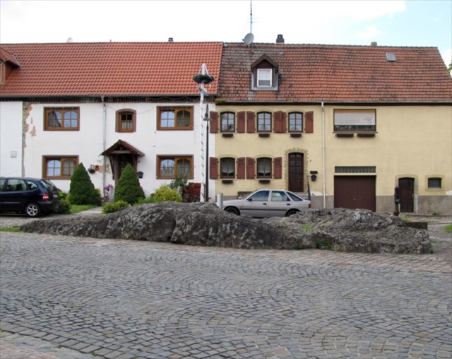

Im Ortskern von Walsheim liegt der "Duppstein", ein Kalktuffrücken,
welcher im Gegensatz zu der geologischen Muschelkalk - Umgebung,
mit einem Alter von 200 Millionen Jahren, nur 10.000 Jahre alt ist.
Hierbei handelt es sich um einen unregelmäßig porösen Kalktuff mit Landschnecken und Pflanzenresten aus dem Quartär.
Der "Duppstein" ist neben dem Kalktuff in Niedaltdorf bei Saarlouis die größte Kalksinterbildung in der Region.
Sinterkalk ist eine Kalkausscheidung einer früher offen zu Tage getretenen Quelle, also kein Meereskalk,
wie man ihn sonst an der Oberfläche des Bliesgaus findet.
Ursprünglich hatte dieser Kalktuff eine Ausdehnung von gut vierzig Quadratmetern
bei einer Dicke von mindestens vier Metern.
Kalktuff entsteht, wenn an Quellaustritten Kalk auskristallisiert und es gleichzeitig zu einem Verlust des zuvor gebundenen Kohlendioxids kommt.
Das Quellwasser erwärmt sich etwas und freies CO2 wird abgeschieden. Das Wasser ist relativ kalkhaltig und es fließt.
Dies sind wichtige Voraussetzungen für die Entstehung des Kalktuffs. Ferner sind Moose und andere pflanzliche Bestandteile an der Bildung des Kalktuffs beteiligt.
Sie lagern sich an das Gestein und beschleunigen so die Entstehung des Kalktuffs und erzeugen eine Vielfalt an Formen und Strukturen.
Ist das Wasser stärker mineralisiert entsteht der sogenannte Travertin.
Travertin ist ein Synonym für den Kalktuff.
Eine weitere Bezeichnung ist Sinterkalk.
Er entsteht als sogenannter Süßwasserkalk mit relativ hoher Dichte überwiegend an Spalten und Höhlen.
Da der "Duppstein" schon seit ca. 10.000 Jahren der Verwitterung ausgesetzt ist, ist seine Oberfläche nicht mehr so wie ursprünglich.
Ebenso haben sich Flechten und Moose angesiedelt.
Aber wenn man genau schaut findet man an geschützten Stellen noch seine ursprüngliche Struktur und Farbe.
Logbedingung :
Stelle dich an die Ecke zwischen dem rechteckigen Brunnen und dem "Duppstein".
Wenn du dich hier ganz nach unten bückst findest Du einen Überhang im "Duppstein".
So vorm Wetter geschützt ist hier die Struktur und die Farbe des "Duppsteins" noch gut zu erkennen.
1. An was erinnert dich diese Struktur und welche Farbe hat hier der Duppstein ?
2. Wieso haben sich diese Strukturen gebildet ?
Maile die Antwort an meine Geocaching.com Adresse. Nicht im Log spoilern !
Warte nicht auf Logfreigabe. Sollte etwas nicht stimmen melde ich mich.
Ps. Wer möchte darf natürlich auch ein Foto von sich vorm Duppstein an das Log hängen.
Ist aber kein Muß
 You can find the Walsheimer - "Duffstein" in the middle of the village walsheim.
The Walsheimer - "Duffstein" is a ridge of tufa with an age of 10.000 years inside
an area of shell lime which has an age of 200 million years.
Here you find the tufa irregular and porous with fossilized snails and plant parts from Quaternary.
Beside the tufa in Niedaltdorf, near the city Saarlouis, the "Duppstein" is the biggest occurrence of tufa here in the region.
The lime here is formed when at outlets of sweetwater sources chalk crystallized and is not sea-lime, which you find normally in the region.
Originally the spot of tufa here had an area of 40 square meters with a height of 4 meters.
Tufa is formed when at outlets of water sources chalk crystallized and simultaneously previously bound carbon dioxide volatilized.
The water warms up a bit and free carbon dioxide is separated off.
The water is relatively calcareous and flows.
These are important preconditions for the emergence of Tufa. Further are mosses and other herbal ingredients involved by the formation of tuba.
They attach themselves to the rock, and so accelerate the formation of tuff and a wide variety of forms and structures.
If the water is higher grade mineralized so the so-called Travertine was created.
Travertine is a synonymous with the tufa.
Another name for tufa is the so-called Sinterkalk.
It arises as a so-called "Süßwasserkalk" with relatively high density mainly at crevices and caves.
Because of the weathering for 10.000 years the "Duppsteins" surface is not what it was in earlier times.
Also you can find mosses and lichen on the stone.
But if you have a closer look you can find the origin structure and colour on secure places
How to log:
Go to the corner between the rectangular fountain and the "Duppstein"
Now look near the bottom. There is an averhang and here you can see the natural structure and colour.
1. the structure looks like ... and what colour it has ?
2. what causes these structures of the stone ?
Send the answers at my geocaching.com profil. Don't spoiler in your log !
Don't wait for approval. If something is wrong i will contact you.
ps. if you want you can attach a photo of you in front of the Duppstein at your log.
It would be "a nice to have " ;-)

Dans le centre de Walsheim se trouve le "Duppstein"
C'est un travertin ou tuf calcaire de 10 000 ans contrairement à la chaux de coquillage géologique des alentours avec 2 millions d'années.
Ici il s'agit d'un tuf calcaire irrégulièrement poreux avec des escargots et des débris de végétaux de la période du Quaternaire.
Le "Duppstein" et le travertin dans Niedaltdorf près de Saarlouis sont les plus grandes formations dans la région.
Le travertin "Sinterkalk" provient d'un dépôt calcaire d'eau douce provenant d'une source, contrairement à la chaux de mer qu'on trouve en surface dans le Bliesgau.
Dans le temps ce travertin avait une surface de 40m2 et une épaisseur de 4 mètres.
Origine du phénomène:
L'eau qui jaillit, a, au préalable, circulé dans une nappe souterraine dans une roche calcaire. Cette eau est donc très chargée en calcaire, mais également en CO2, dissous. Sous les actions combinées des algues, moussses, de l'agitation et d'autres facteurs physico-chimiques, le calcaire (carbonate de calcium) précipite. Le plus souvent cela emprisonne des débris de végétaux, dont l'empreinte sera conservée, éventuellement pour des millions d'années.
Le tuf calcaire, (appelé également travertin) provient de l'encroûtement de la végétation aquatique et des plantes riveraines.
Puisque le "Duppstein" est déjà exposé depuis 10 000 ans aux intempéries sa surface n'a plus sa structure d'origine, mousses et lichens se sont établies.
Conditions pour le log:
-Placez vous au coin entre la fontaine rectangulaire et le "Duppstein".
-Penchez vous vers le bas et en dessous d'un dépassement vous trouvez ici la structure et la couleur d'origine du "Duppstein" qui ont été très bien conservées.
1. Qu'elle est la couleur du "Duppstein" et que vous rappelle sa structure?
2. Comment se sont formées ses structures?
Envoyez vos réponses par mail via mon profil.
Vous pouvez loger de suite, si erreur, je vous contacte.
PS. Une photo de vous prise devant le "Duppstein" est souhaitée et placée dans le log.
Informationen sind teilweise aus Wikipedia sowie aus http://www.gersheim.de entnommen.
Vielen Dank an Saluva57 für die Übersetzung in's Französische.
Additional Hints
(No hints available.)