The Mecan river is spring fed and flows on sand and gravel. It is therefore clear and fast-flowing. The Chain of Lakes is a tunnel channel and the Ice Age Trail is along the south side where you will have excellent views. Ice Age Trail Atlas Map #48.
Reprint permission granted by Ian Freeman, Rebecca Moore, and Kent Syverson, Dept. of Geology, UW-Eau Claire
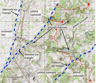
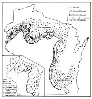
 Other than the glacier itself, water has produced more of our landforms than any other process. Very cold temperatures at the base of a glacier prevented water from flowing out beneath the ice. Subglacial rivers cut into the underlying glacial bed. Eventually, water under high pressure exited and cut a gorge or tunnel channel. In Wisconsin, such channels occur along the outermost edge of the late Wisconsin advance. The water flows that cut tunnel channels were apparently sudden, short-lived, and huge. They carry a large flow of glacial melt-water from beneath the ice creating broad troughs. The water in some channels actually moved upslope under pressure from the glacier and the weight of the overlying ice pushed debris-rich glacial ice into the valley to fill the space that had been occupied by water. This left many tunnel channels partially filled with hummocky sand and gravel, sometimes creating an esker.
Outwash fans occur along moraine fronts where tunnel channels exited the glacier.
© 2011 by the Regents of the University of Wisconsin System. Reprinted by permission of The University of Wisconsin Press
 IATCC is the cache designation to highlight a series of EarthCaches along the Ice Age National Scenic Trail grouped into a special category called "ColdCache."
The Ice Age Trail is one of eleven National Scenic Trails designated by the National Park Service. This unique trail is entirely within the state of Wisconsin and follows along the terminal moraine of the most recent glacier which retreated about 10,000 years ago.
This project is supported by the Ice Age Trail Alliance (IATA). The goal is to bring more visitors to the trail and promote public awareness, appreciation, and understanding of Wisconsin’s glacial landscape.
The IATA has created an awards program to encourage visits to the trail and ColdCache sites. This awards program is separate from, and in addition to, any other Geo- or EarthCache awards program.
A current list of approved ColdCache sites can be found on the “IATCC Bookmark List”. More information on the Ice Age Trail Atlas, the Companion Guide, the ColdCache Project and Awards Program can be found on the “ColdCache Webpage”
The Geocache Notification Form has been submitted to Jim Tomasko of the Wisconsin DNR. Geocaches placed on Wisconsin Department of Natural Resource managed lands require permission by means of a notification form. Please print out a paper copy of the notification form, fill in all required information, then submit it to the land manager. The DNR Notification form and land manager information can be obtained at: www.wi-geocaching.com/hiding
Resources:
Geology of the Ice Age National Scenic Trail; by David M. Mickelson, Louis J. Mahler Jr., and Susan L. Simpson
Roadside Geology of Wisconsin; by Robert H. Dott, Jr. and John W. Attig
1. Estimate the slope and height of the embankment from the top to the springs.
2. Estimate the distance to the top of the embankment on the opposite side.
3. Based on your observations, what direction do you think the ice was moving & why?