Isolukko, Kangasala EarthCache
-
Difficulty:
-

-
Terrain:
-

Size:  (not chosen)
Please note Use of geocaching.com services is subject to the terms and conditions
in our disclaimer.
(FIN) Earthcache joka esittelee ison harjulukon eli supan Kangasalla.
(ENG) Earthcache that introduces Big esker kettle at Kangasala.
 tämä on Earthcache joten et löydä paikalta kätkölaatikkoa tai logikirjaa tähän kätköön liittyen. Tällä Eartcachella käynti osoitetaan suorittamalla kätkökuvauksessa kerrotut tehtävät. Eartcacheen eli maakätköön kuuluu oleellisena osana kohteen geologiaan liittyvä opetuksellisuus.
 This is an Earthcache so you won't find any items, box, physical cache or logbook at this site. you can log you visit by doing given tasks. Each EarthCache provides educational notes about current place geology.
 Isolukko; GC42TV5
Kangasalan harjut ja Isolukko
(skip to English section.)
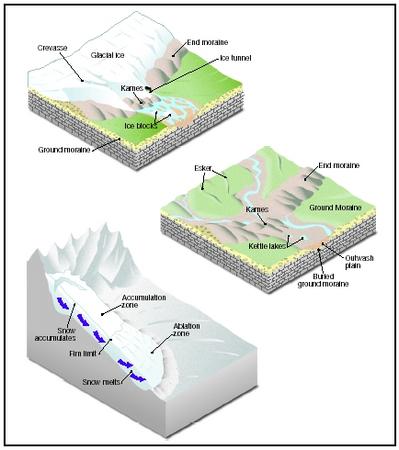
Harjun muodostuminen
Harju syntyy virtaavan jäätikköjoen kuljettaman maa-aineksen laskeutuessa kanavassaan jäätikön sisällä, ja jäätikköjoen suulla. Jäätikköjoen purkautuessa mereen sen suulle vedenpinnan alle voi kerrostua maa-aineksesta delta (suisto) tai maan pinnalle purkautuessa sanduri (kuivan maan delta). Harjujaksot muistuttavat karttakuvissa jokisysteemiä, joka kuvastaa jäätikkökielekkeen muotoa. Leveää ja loivarinteistä deltaa muodostuu jos jäätikkö ei vetäydy, ja jyrkempirinteistä ja kapeampaa harjua jäätikön vetäytyessä. Harju (ent. pitkittäisharju) muodostuu jäätikön vetäytymissuuntaiseksi.
Talvi ja kesä vaikuttivat eri lailla sulamisvesien virtauksiin ja sen seurauksena maa-aines koostuu erilaisista hiekka- ja sorakerrostumista. Pohjimmaiseksi kasautui isoja, jäätikköjoen virtauksessa pyöristyneitä kiviä ja päällimäiseksi hiekkaa. Harjut polveilevat, koska maaperän muodostumat (esim. kukkulat) ovat vaihtaneet jäätikkövirtojen suuntaa.
Jääkauden lopulla yli 9000 vuotta sitten syntyneet soraharjut ovat Suomelle tunnusomaisia maastonmuotoja. Soraharjuja on käytetty paljon soranottoon, mutta nykyään harjumaisemia on alettu suojella. Suurin yhtenäinen soraharjujono (vetäytymissuuntaisia) Suomessa ulottuu Etelä-Pohjanmaalta Lahden seudulle. Pohjoispäässä harjumuodostelmaa on Etelä-Pohjanmaalla Pohjankangas, sen jälkeen Hämeenkangas. Pyynikin harju jatkuu länteen päin Tahmelana tunnettuna kallioisena harjuna ja itään päin harju nousee Tampereen kaupunkiasutuksen jälkeen Kalevankankaaksi. Kangasalla harjumuodostelma jatkuu Kirkkoharjuna ja Keisarinharjuna. Harjujono päättyy Salpausselkään.
Petäjät eli männyt ovat vallanneet suurimman osan harjujen rinteitä ja keväisin varsinkin Etelä- ja Keski-Suomessa sinivuokot koristavat sinisillä ja sinipunaisilla kukillaan etelän puoleiset rinteet. Soraharjut ovat luonnonkauniita maisemallisesti. Soraharjuilla on usein suppia. Suppa syntyy jäälohkareen joutuessa kasautuvan aineksen sisään ja lopulta sulaessa satojen vuosien aikana, jolloin paikalle muodostuu kuoppa.
Kangasalan maaperän synty
Kun mannerjäätikkö peitti Kangasalan aluetta, sen jää virtasi luoteesta kaakkoon (suunnasta 315° - 330°). Virtaavan jään irrottama, kuluttama ja kuljettama kiviaines kerrostui jäätikön pohjalla moreenikerrokseksi. Moreenia on laajalti varsinkin kunnan länsi- ja eteläosien ylänköalueilla. Moreenin pintaosaan on jään sulamisen loppuvaiheessa rikastunut kiviä ja lohkareita yleisesti. Laaksoissa ja muissa painanteissa moreeni on peittynyt laajoilla aloilla sitä nuorempien, hienorakeisten ja eloperäisten maalajien alle. Mannerjäätikön sulamisvaiheessa jäätikön pohjalla virtasi vuolaita sulamisvesijokia, joissa moreeni peseytyi, kivet pyöristyivät ja maa-aines lajittui ja kerrostui sora- ja hiekkamuodostumiksi, harjuiksi. Esimerkiksi Vehoniemen - Kangasalan kautta kulkee harjujakso, joka on tavanomaista kookkaampi, nk. saumaharju.
Kangasalan kunnan alue vapautui mannerjäätiköstä noin 11 000 vuotta sitten, mutta jäi siinä vaiheessa vielä muinaisen Itämerivaiheen, Yoldiameren, peittämäksi. Vain muutamien, lähinnä Kangasalan pohjois- ja itäosassa sijaitsevien mäkien laet jäivät yksinäisinä saarina vedenpinnan yläpuolelle. Nykyisin tämä nk. ylimmän rannan taso on kohonnut jo noin 155 m:n korkeudelle merenpinnasta. Sulamisvesien manner-jäätiköltä kuljettama liete kerrostui syvässä vedessä moreenin päälle hienorakeisten maalajien kerrostumiksi, jotka Kangasalan alueella ovat pääasiassa lustosavia.
Jäätikköjokimuodostumat
Kangasalan kunnan läpi kulkee mahtava ja monin paikoin maisemallisesti kaunis saumaharju. Sen osien nimityksiä ovat luoteesta kaakkoon Kirkko-, Kuohun-, Keisarin- ja Vehoniemenharju. Ketju päättyy Kangasalan osalta laajalle Isokankaalle. Kaikki em. harjanteet nousevat ympäristöään 40 - 50 m korkeammalle. Kirkkoharjulla saumaharjuun yhtyy pienempiä harjuja pohjoisesta, mm. Metsäkulmalta. Kuohunharjun kohdalle yhtyy pohjoisesta, Pikonlinnalta tuleva harju. Kirkkoharju-Isokankaan saumaharjujaksossa on eri puolilla lukuisia muinaisia rantamerkkejä, tasanteita ja törmiä. Kirkkoharjun laella oleva tasanne, noin 155 m mpy, on ylimmän rannan tasoittama. Supista Kirkkoharjun Isolukko sekä Isokankaan Mustalukko ja Punamultalukko ovat Suomen suurimpien joukossa, syvyydeltään noin 40 m. Seismisten luotausten mukaan maaperän paksuus on Kirkkoharjulla 38 - 50 m, Keisarinharjulla 45 - 56 m ja Isokankaalla Punamultalukon vieressä 42 - 57 m.
Kangasalla ei ole harjuja edellämainitun saumaharjukokonaisuuden lounaispuolella. Koillispuolella sen sijaan on useita pieniä, usein lyhyitä ja katkonaisia harjuja mm. Majaalahden tienoilta kaakkoon Ihariin, Kirkkojärven lounaisrannan suuntainen harju, pohjois-eteläsuuntainen harju Pakkalanjärven pohjoispäässä, Moltsian – Välimaan harju ja itäisimpänä Vähä-Saksijärven pieni harju.
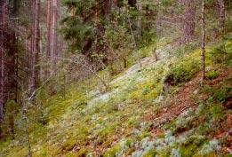
Isolukko
Isolukon lukkoalueeseen kuuluu kaksi eri aikoina rauhoitettua toisiinsa liittyvää luonnonsuojelualuetta. Pikkulukoksi kutsuttu alue on rauhoitettu 12.8.1980 päivätyllä päätöksellä. Noin kahdenkymmenen hehtaarin laajuinen alue Kirkkoharjusta, johon Isolukko kolmen pienemmän supan kanssa kuuluu, on rauhoitettu 15.7.1987 päivätyllä päätöksellä. Rauhoituspäätöksen mukaan alue on pinnanmuodostukseltaan ja maisemiltaan vaihteleva sekä ulkoilun kannalta tärkeä, joten sen rauhoitus edistää huomattavaa yleistä etua. Isolukon lukkoalueella voikin tutustua sekä jääkauden jättämiin jälkiin että harjuluonnon, erityisesti suppien, mielenkiintoiseen kasvillisuuteen. Isolukko on Kangasalan laajin ja Punamultalukon jälkeen syvin suppa. Kirkkoharju, jolla rauhoitusalue sijaitsee, on merkittävä osa kunnan virkistysalueverkostoa ja alueelle on kunnan ylläpitämien ulkoilureittien lisäksi muodostunut tiheä polkuverkosto. Lukkoalueella kulkee koulujen käyttämä luontopolku.
Jotta voit merkitä logatuksi tämän kätkön sinun
täytyy suorittaa seuraavat tehtävät annetuissa koordinaateissa:
1 )
Kulje referennssipisteestä lookout 1 (Reference Point) N 61° 28.625 E 024° 01.020
boguspisteen N 61° 28.670 E 024° 01.110 kautta
Referenssipisteeseen lookout 2 (Reference Point) N 61° 28.710 E 024° 01.215
tai päinvastaiseen suuntaan.
Huomioi että talvella alueella on hiihtolatuja joilla kävely on kielletty.
Tee matkalla havaintoja harjulukon rinteestä;
Voiko rinteessä havaita erilaisia maalaji kerrostumia? Kuvaile minkälaisia ne ovat? (Partikkelien koko, niiden jakauma yms?) Kuinka mahdolliset kerrostumat ovat syntyneet? Mitä maalajia harju on?
(Talviseen aikaan tehtävän mukaisten havaintojen tekeminen on toki hankalampaa lumipeitteen takia. Talvellakin lukko on kyllä vierailemisen arvoinen ja vastauksiksi hyväksytään pääsääntöisesti tällöin soveltuva tarkkuus / oikeansuuntainen päättely).
2 )
kuvittele että kuopan kohdalla on olut harjun syntyessä nykyisen lukon kokoinen jääkimpale. Arvioi tuon kimpaleen koko.
3 )
Vapaaehtoinen tehtävä;
millainen ilmasto lukon pohjalla vallitsee käyntihetkelläsi? miten se eroaa ympäröivästä ilmasta? miksi?
4 )
Lähetä vastauksesi kätkön omistajalle vaikkapa tällä viestilinkillä.
Kirjoita viestin otsikoksi Isolukko, Kangasala
(ps. jos valitset viestin alta "I want to send my email address along with this message" vastaamiseni helpottuu)
5 )
Sinun ei tarvitse odottaa loggauslupaa, mutta asiattomat logit tullaan poistamaan. Omistaja vastaa jollain aikavälillä viestiin, jos vastauksissa on epäselvää.
6 )
Toivottavaa on myös että otat valokuvan itsestäsi ja/tai gps laitteestasi pisteessä N 61° 28.670 E 024° 01.110 lukon pohjalla siten että rinteen jyrkkyys/korkeus on kuvasta havaittavissa , ja liität se logiisi.
Kangasala's eskers and “Isolukko”
The formation of esker and other similar edgeformations
The ice age modified Finland’s soil in a many different ways. Thick ice cover wiped out slowly all the life forms and vegetation by expanding. At the end of the ice age the glacier slowly reverted and it came possible to life forms and vegetation to slowly return to the formerly ice covered areas.
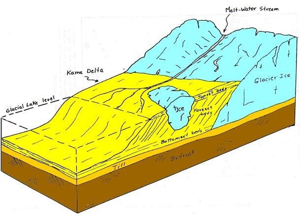
In the expansion process the thick ice layer (glacier) slowly grinded the bedrock by a massive force and weight. Also all the material like stones carried by the ice participated in the grinding process. The movements of the glacier produced about 7 meters thick moraine layer. The glacier carried different size of stones with it, which grinded the bedrock and loosen the moraine. At the end of ice age, the glacier reverted slowly and modified the surroundings, and left gravel eskers, like this area of Kalevankangas Esker. The eskers form mainly of sand and gravel, and have formed mainly after the last ice age, like about 10 000 years ago, during the melt of continental glacier. The melting streams of ice glacier carried and formed a layers of ground-material at the edge of melting glacier, under the glacier and between the melting water streams. Esker is formed by ground material which is carried by Ice Rivers forming from the water streams of melting ice. When the ice-river comes apart from the glacier and it comes apart under water it forms a delta-area. When the ice-river comes apart to a surface of a land, it forms a sandur, which is a form of a dry lands delta.
Broad and gentle sloped delta-area is formed if the glacier is not reverting. The steep hills and narrower esker is formed when the glacier is reverting. Esker, formerly as a longitudinal-esker is forms in the direction of the reverting glacier.
Winter and summer affected differently to the melting water streams and because of that the ground material formed from a different kind of sand- and gravel-layers. The heaviest rocks and materials are at the bottom and at the shallow is the lighter sand. There can also be found very round rocks grinded by the glacier river at the bottom of the esker.
Eskers and edge formations are some of the remarkablest geological formations in a scale of Finland. The eskers and edge formations cover approximately 4% of the land area in Finland. The eskers in Finland are also internationally especially remarkable, if you know where to find and were to look at them.
Pine trees have taken over most of the slopes of esker. The forest type of eskers is mainly dry boreal forest of pine forest vegetations type. One of the end vegetation types of eskers is slopes consisting of gravel and sand with heavy sun light, where man can find rare and endangered species and vegetation, flora and fauna. The diversity of eskers is complement mostly with spruce filled shady slopes, mostly at the northern sides of eskers. Also its remarkable that there are kettle holes with certain kind of and very special microclimate.
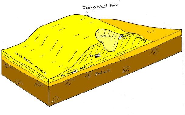
There are very ofteh kettle holes at the eskers. Kettle hole is formed when a iceboulder gets under a forming groundmaterial. At the end, the iceboulder melts very slowly during a hundreds of years, and that forms a kettle hole. Because kettle hole is a sort of a pit, it collects a colder air or climate than the surrounding area. That happens because the colder air is heavier than warm air. The climate in kettle hole is almost always little bit colder than the surrounding climate at the esker. The kettle holes in eskers for as its best own microclimate which differs from the surrounding climate. This can be seen specially at spring, when the snow has already melted from the surrounding of the esker, but the can be still snow at the kettle hole. In Kangasala these kettle holes are often called as locks.
Many of the eskers are very rich in radon, many but not the all of them. Radon is a radioactive gas which penetrates very easily to apartments without radon protection. Radon provides specially chanllenges to building sites and apartments at the esker sides: The apartments has to be build with a certain kind of radon protection, so that the gas cannot access to the apartments. It has been found out at the studies that the radon gas is increasing the possibility to get lung cancer. Theres radon gas almost everywhere in the globe so theres no need to panic. Radon gas is the most common source of the background radiation, and it’s a sign of a normal radioactive decay chain of uranium and thorium. Uranium and thorium have been around since the earth was formed and their most common isotope has a very long half-life (4.5 billion years). Uranium and thorium, radium, and thus radon, will continue to occur for millions of years at about the same concentrations as they do now.
The rising of earth after Ice age
The cause of earth rising is the glacier. The glacier was extremely thick and heavy, and caused the earth to descent thousands of years. You can imagine a spring: when holded down by your fingers it wants to expand. And when you release it, it expands. Same is happening here, of course not so fast what the spring does, but very slowly. And now, when the glacier has melted away about 12 000 years ago, the earth is still rising slowly to its original state.
Isolukko
This Kettle hole is called “Isolukko” or "Big lock". Area includes two inter-related nature reserve. Area called “Pikkulukko” is protected by a Decision dated 12.08.1980. Approximately twenty-hectare area, with three smaller falls, is protected by a Decision dated 07.15.1987. The Protected area has rare topography and scenery, as well as it is important for outdoor recreation, so its preservation promotes public interest substantially. "Isolukko" is the largest a lock at Kangasala.
To log this cache you must do following tasks in given coordinates:
1 )
Walk from reference point lookout 1 N 61° 28.625 E 024° 01.020
via boguspoint N 61° 28.670 E 024° 01.110 to
Referencepoint lookout 2 N 61° 28.710 E 024° 01.215
or other way.
On you way make notices of kettle hole slopes? Can you see different layers in the soil? discribe How does those layers differ from each other? (...Size of the particles, their distribution, etc?) How are those possible different layers formed? from what soiltype is slopes formed from?
Please note that during the winter there is skiingtracks on the area, and the walking on those is prohibited.
2 )
Imagine, that during the birth of this esker there was an ice block at this same place that was as big as this kettle hole. evaluate the size of the iceblock that caused the birth of the lock.
3 )
Optional task about biology:
what kind of climate there is on the bottom of the lock during you visit? how doeas that differ from the "outside" climate? Why?
4 )
Send your answers (for example via this message link) to the cache owner.
Title your post “Isolukko, Kangasala”
(ps. if you enable selection "I want to send my email address along with this message" it is easier for me to reply)
5 )
You don't have to wait for a logging permission, but any incomplete logs will be deleted. Cache owner will reply something for post if there is some faults in answers.
6 )
It is hoped that you take a photo of yourself and / or your GPS device at bottom of the lock at point N 61 ° 28.670 E 024 ° 01.110 , so that the steepness / height of the slope is visible in image is and then paste it to you log.
Kangasala, Oksalla ylimmällä,
on a branch at the top
In the past the nobility discovered Kangasala in the midst of the country of blue lakes and sunny ridges when they needed a refreshing change in their lives. Kangasala has also offered inspiration for many significant national artists through the years.
Tämä earthcache sarja on omistettu Kangasalan luonnolle
This earthcache series is dedicated to the praise the Beautiful Nature of Kangasala
Kangasalan earthcachet :
 Pallograniitti ja verikivi, Kangasala, GC3R3NK
Isolukko, Kangasala, GC42TV5
Haralanharju, Kangasala, GC42TY4
Muuttuneet virrat, Kangasala, GC42YW6
- Maitomies -
you can also contact cache owner via facebook:

Additional Hints
(No hints available.)