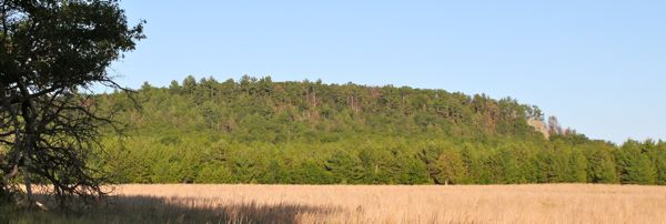
Quincy Bluff and Wetlands is a Wisconsin State Natural Area in central Adams County that consists of over 3000 acres of preserved land owned by both the Wisconsin DNR and the Nature Conservancy. While there are several access points to different parts of the natural area, this cache will take you along 16th Drive to the west of the bluff itself, where you will have several views of the bluff and the original Nature Conservancy acquisition. Click on the "Related Web Page" link under the cache name above to see more of what this area has to offer (tab for "recreation"). Maps of the property can also be found here and at the link provided on the DNR web page to the Wisconsin Nature Conservancy site (look for "Properties We Protect".)
While you will not need to get out of your car at any of the waypoint locations (just at the final), and while no part of this cache is on state natural area property, you may want to park in the lot near the given coordinates to read about Quincy Bluff at the informational kiosk, and to embark on further exploration of the natural area on foot. All of the property abutting 16th Drive on the west is privately held, and the property abutting the east side is a checkerboard of private and public lands. The final of this multicache is on private property, and permission has been granted by the owner for its placement.
To follow this multicache from point to point, you will drive to certain locations (with different views of Quincy Bluff along the way), and make observations at each location that (with some accurate figuring) will lead you to each subsequent stage location. All of the directions listed below are also contained in a handy-dandy "cheat sheet" that you can find in the gallery for this cache, should you want to print off a paper copy to have with you on your drive from point to point.
*********************************************************
At the given coordinates you used to be able to look to your east to see a reddish-brown sign with white letters that was necessary to get your next set of coordinates. Now you just need to check out the photo in the cache page gallery to help you figure out where to go next. Count how many of each letter you see on the top board of the sign in that photo, and then use those values to fill in the blanks in the coordinate puzzle below. Then you will go to the coordinates that you just figured out to work the puzzle for the next stage.
# B + # P = A
(# C + # U) * 2 = B
# D + # K = C
# R + # E = D
# F + # N = E
(# U + # R) * 2 = F
(# E * 2) + # S = G
# V + # M = H
Stage 2 can be found at: North 43˚ 5A.BCD West 089˚ 5E.FGH
*********************************************************
At the coordinates for stage 2 you will see two green and white signs with numbers and letters on them. Look at the numbers on the signs, and also count how many of each letter is on both signs together, and use those values to fill in the blanks in the coordinate puzzle below. Then you will go to the coordinates that you just figured out to work the puzzle for the next stage.
# R + # L = J
2nd # + # A = K
# E + # Q = L
# C + # F = M
1st # + # O = N
# S + # D = P
2nd # + # Y = Q
# U + # G = R
Stage 3 can be found at: North 43˚ 5J.KLM West 089˚ 5N.PQR
*********************************************************
At the coordinates for stage 3 look east where you will see a faded sign with four large red digits on it arranged vertically. We will call those (read top to bottom) V#. Above those four numbers are two smaller digits and one letter, arranged horizontally. We will call those (read left to right) H#. Use the identified six digits to do some math that will fill in the blanks in the coordinate puzzle below. Then you will go to the coordinates that you just figured out to work the puzzle for the next stage.
2nd V# minus 2nd H# = S
1st H# plus 2nd H# = T
4th V# minus 1st V# = U
1st V# plus 2nd V# = V
1st H# plus 1st V# = W
2nd H# plus 1st V# = X
3rd V# minus 1st V# = Y
4th V# minus 1st H# = Z
Stage 4 can be found at: North 43˚ 5S.TUV West 089˚ 5W.XYZ
*********************************************************
At the coordinates for stage 4, look west where you will see (from left to right) a black sign with white letters on it, a cutout animal figure, and a red sign with letters and numbers on it. Look at the numbers on the red sign, and also count how many of each letter is on both signs together, and use those values to fill in the blanks in the coordinate puzzle below. This will give you the coordinates of the final location of the cache
3rd # + # U = A*
2nd # + # M = B*
# E + # Y = C*
# O + # K = D*
4th # + # L = E*
# C + # N = F*
3rd # + # A = G*
1st # + # W = H*
The cache container can be found at: North 43˚ 5A*.B*C*D* West 089˚ 5E*.F*G*H*
Hint for the final hiding spot: Identify the cutout animal figure between the two signs.
If the animal is a BEAR, the hint is “under the Christmas tree”.
If the animal is a DEER, the hint is “tucked in between two downed logs”.
If the animal is an EAGLE, the hint is “covered with bark at base of big tree”.
*********************************************************