As you climb up the hill towards the White Horse from the recommended parking point you will see The Manger on your left hand side. The Manger is an unusually shaped dry valley that occurs across the outcrop of chalk.
Dry valleys are an interesting feature geologically in that there are many theories as to how they are formed, however the most plausible theory, borne out by geological fieldwork, is that this one was formed from retreating permafrost during the most recent Pliocene-Quaternary Ice Age that began 2.58 million years ago.
During the last Ice Age the layer of groundwater that filled the pore spaces of soil and rock became permanently frozen. As the ice sheet receded during the period of climate change the “active layer” of soil close to the surface of permafrost regions underwent seasonal and daily freeze-thaw cycles through a process of solifluction (soil flow) where the ground began to thaw from the surface downward. All of the freshly melted water could not absorb into or move through the permafrost layer and therefore caused the upper layer of soil to become saturated and flow down the slightest of slopes as it slipped over the frozen ground underneath.
In order to log this cache you need to answer the following questions:
- During which period was the downland you are standing on formed?
- Can you estimate how long and deep the dry valley is?
- Looking at The Manger from Waypoint 1, what can you see? How were these formed during the Ice Age?
- What do you notice about the surface drainage on The Manger and why might this be?
Answers to be emailed, not included in your log. Once you have emailed me you are free to log the cache as found.
A photo of The Manger is not a requirement of geocaching.com but it would be good if you could upload one for all to enjoy.
A visit to The Manger would not be complete without taking in all the other features on White Horse Hill, including the Bronze-Age White Horse itself, Uffington Castle, a trig point and Dragon Hill, where it is reputed in legend that St George slew the dragon. There are also some excellent traditional caches in the area that form enjoyable circular walks. Waypoint 2 takes you to the a good vantage point for the Castle and trig point.
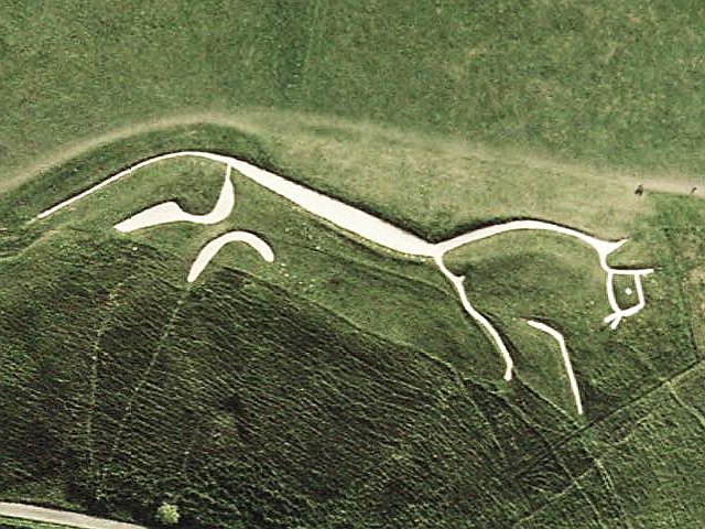
PLEASE NOTE: The White Horse is fragile and carefully managed by the National Trust. Please do not walk on the horse.
 Placed with the kind permission of the National Trust