Ponto de Partida: Queimadas
Ponto de Chegada: Queimadas
Tempo: 5h30 (ida e regresso)
Extensão: 13 Km
Leve o seu almoço
Leve lanterna
Este trilho percorre a esplanada da levada do Caldeirão Verde numa altitude dos 990m no Concelho de Santana. Este percurso tem início e fim no Parque Florestal das Queimadas, numa extensão de 6,5 Km (+ 6,5Km de regresso), numa duração de 5h 30m (ida e regresso).
No Parque Florestal das Queimadas encontra-se a Casa de Abrigo das Queimadas, que mantém as características originais das Casas Tipícas de Santana, apresentando telhado em colmo. Neste Parque existem espécies vegetais arbóreas algumas exóticas realçando exemplares de criptoméria elegante (Cryptomeria japonica) e de faia europeia ( Fagus sylvatica); e outras indígenas como o cedro da Madeira (Juniperus cedrus), o til (Ocotea foetens), o pau Branco (Picconia excelsa), urze (Erica platycodon subsp. maderincola), folhado (Clethra arborea), uveira da serra (Vaccinium padifolium).
Ao iniciar o percurso logo é encontrada a esplanada da levada do Caldeirão Verde. Esta levada, é uma impressionante obra de arte construída no século XVIII, tem início no leito principal da Ribeira do Caldeirão Verde e atravessa por abruptas escarpas e montanhas, transportando a água que escorre das mais altas montanhas da ilha da Madeira, para o regadio dos terrenos agrícolas da freguesia do Faial. Esta levada constitui uma importante via no interior do vale profundo da Ribeira de São Jorge oferecendo ao caminhante uma vertiginosa e espectacular visão da orografia do interior da ilha e a possibilidade de passar por túneis escavados na rocha pelo Homem.
Ao longo do percurso são observadas espécies vegetais pertencentes à Floresta Laurissilva do Til e do Vinhático destacando-se o til (Ocotea foetens), o loureiro (Laurus novocanariensis), o folhado (Clethra arborea), o sanguinho (Rhamnus glandulosa), o perado (Ilex perado), leituga (Sonchus fruticosus), o aderno (Heberdenia excelsa), a corriola (Convolvulus massonii), sabugueiro (Sambucus lanceolata), piorno (Teline madeirensis), o isoplexis (Isoplexis sceptrum) e o alegra –campo (Semele androgyna). Para além destas espécies podem ser observadas com grande frequência as urzes das vassouras e molar (Erica platycodon subsp. maderincola e Erica arborea) e a uveira da serra (Vaccinium padifolium).
Neste percurso também podem ser observadas espécies de avifauna indígena destacando-se o tentilhão (Fringilla coelebs), o bisbis (Regulus ignicapillus madeirensis), o Pombo Trocaz (Columba trocaz trocaz), a Lavadeira (Motacilla cinerea schmitzi) e a manta (buteo buteo harteti).
Ainda no início do percurso pode ser avistado um pequeno aglomerado populacional, trata-se da Achada do marques, sítio contemplado com o estatuto de Paisagem Protegida caracterizado pelos tradicionais poios agrícolas e antigos palheiros de pedra.
Depois de passar pelos 4 túneis existentes ao longo do percurso, o Caldeirão Verde surge à esquerda da levada e para lá chegar, basta subir alguns metros pelo leito do ribeiro. Para passar estes túneis, uns mais extensos do que outros, é necessário atenção pois o piso é escorregadio.
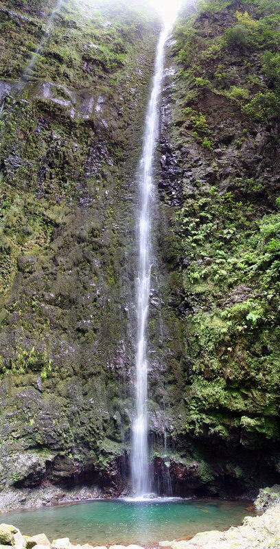
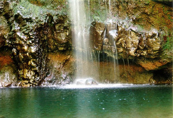
O lago do Caldeirão Verde é formado pela água que se projecta verticalmente do leito do Ribeiro do Caldeirão Verde a uma altura de aproximadamente 100m.
Depois de repousar um pouco e apreciar a paisagem natural envolvente e a espectacular cascata, é tempo de regressar percorrer o mesmo trilho até ao Parque Florestal das Queimadas.
Starting Point: Queimadas
Check Point: Queimadas
Time: 5H30
Length: 13 Km (outward and return)
Take your lunch
Take flashligt
This trail runs along the esplanade of the Caldeirão Verde taken from an altitude of 990m in the Municipality of Santana. This route begins and ends at Queimadas, a distance of 6.5 km (+ 6.5 km return), a duration of 5h 30m (outward and return).
Queimadas is the Shelter of fires, which maintains the original characteristics of the typical houses of Santana, featuring thatched roof. In this park there are some exotic tree species highlighting examples of elegant cryptomeria (Cryptomeria japonica) and European beech (Fagus sylvatica) and other indigenous as cedar wood (Juniperus cedrus), the tilde (Ocotea laurel), Dick White ( Picconia excelsa), heather (Erica platycodon subsp. maderincola), rolling (Clethra arborea), uveira the mountain (Vaccinium padifolium).
When starting the route is found immediately taken from the terrace of the Caldeirão Verde. This led, is an impressive work of art built in the eighteenth century, begins in the main bed of Ribeira do Caldeirão Verde and crosses by steep cliffs and mountains, carrying the water that runs off the highest mountains of the island of Madeira, for the irrigation of agricultural land in the parish of Faial. This is an important route taken inside the deep valley of the Ribeira de São Jorge offering hikers a dizzying and spectacular view of the topography of the island's interior and the possibility of going through tunnels carved into the rock by man.
Along the route are observed plant species belonging to the Laurel Forest Til mahogany and highlighting the tilde (Ocotea laurel), laurel (Laurus novocanariensis), the rolling (Clethra arborea), the Buckthorn (Rhamnus glandulosa), the perado (Ilex perado) leituga (Sonchus fruticosus), the Aderno (Heberdenia excelsa), morning glory (Convolvulus massonii), elderberry (Sambucus lanceolata), Piorno (madeirensis Teline), the ISOPlexis (Isoplexis sceptrum) and rejoices field (Semele androgyna ). Apart from these species can be observed with great frequency heather brooms and molar (Erica platycodon subsp. Maderincola and Erica arborea) and the Sierra uveira (Vaccinium padifolium).
This route can also be observed species of birds indigenous highlighting the chaffinch (Fringilla coelebs), the Madeiran firecrest (Regulus ignicapillus madeirensis), the Trocaz Pigeon (Columba Pigeon Pigeon), the Laundress (Motacilla cinerea schmitzi) and blanket (buteo buteo harteti ).
Even at the beginning of the route can be seen a small cluster population, it is the Achada of marques, site awarded the status of protected landscape characterized by traditional agricultural poles and old stone barns.
After spending the 4 existing tunnels along the route, the Green Cauldron appears to the left of and taken to get there, just a few feet up the bed of the brook. To pass these tunnels, some more extensive than others, attention is necessary because the floor is slippery.
The lake's of Caldeirão Verde is formed by water that protrudes vertically from the bed of the Brook Caldeirão Verde at a height of approximately 100m.
After resting a bit and enjoy the natural surroundings and the spectacular waterfall, it is time to go back to the same track until Queimadas Forest Park.