About the Hide:
17/11/2024:I am aware that part of the cache container is broken. Disappointed, as the outer container is the part that appears to have been broken due to mishandling, its design is quite robust. I did not print this container, I bought it. I am looking for a replacement but the person who created ut us no longer selling these. If I am unable to find an alternative supplier, or alternative container, I will have to archive this cache. Please treat the remnants with care.
The cache container is in two parts - an inner which holds the log, and an outer which contains the magnet and holds the inner. You need to slide the inner out of its slot in order to remove the logsheet. Just use your thumb to slide the inner to a position to get it out. The label will show you the directions. NO NEED FOR TWEEZERS. Please make sure the inner is firmly back in its slot before returning the container to its hiding spot. There is no pen/pencil please BYO. With such a narrow logsheet, I am happy if you just initial and date to 'sign' the logsheet.
You should be able to retrieve the cache from the seated position.
About the Site:
The Jubilee Bridge was the first bridge built connecting Southport with Main Beach and Surfers Paradise, called Elston till 1933. It was constructed in 1925 and was named in honour of 50 years since the first Southport land sale in 1875. Originally the bridge contained a drawbridge lifting section which would accommodate larger vessels such as the Maid of Sker (currently preserved in a park at Nerang) but this lifting span was removed in 1933 since there was no longer any significant river traffic to Brisbane.
Jubilee Bridge 1926. Photo taken Southport side - note the undeveloped nature of Main Beach.
photo courtesy of the Gold Coast City Council Local Studies Library
The bridge was replaced by the current “Sundale” bridge in 1966 and the remains of the Jubilee Bridge demolished.
This cache is sited on the southern side of the bridge, traffic heading south over the bridge would have continued travelling along what is now Main Beach Parade behind you to reach Surfers Paradise. Prior to the construction of the bridge the only way to access Main Beach was via Boulton’s passenger ferry or private boat. Vehicles had to cross the Nerang River by means of Meyers Ferry at Cavill Ave.
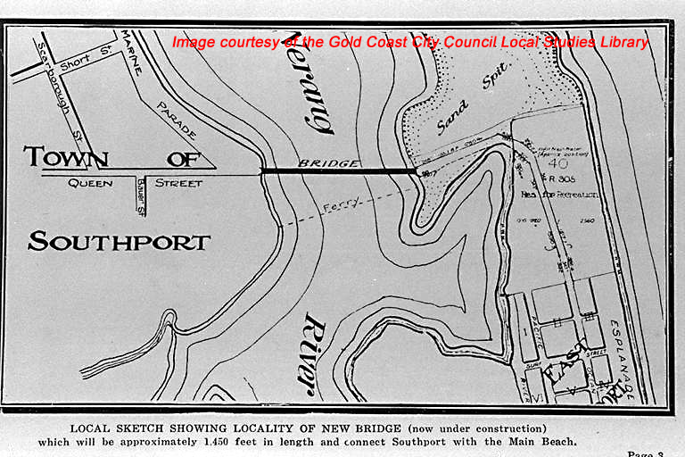 photo courtesy of the Gold Coast City Council Local Studies Library