Despite a modest elevation of 3364 feet, Anderson Mountain is actually the 50th most prominent peak in Washington. Located at the south end of Lake Whatcom, Anderson can be easily seen from both Whatcom and Skagit counties. Unlike many of the nearby mountains, Anderson largely remains heavily forested and undeveloped.Not including its large logging road network, the only official trail on Anderson is the PNT (Pacific Northwest Trail), which makes a full east-west traverse of the mountain. Anderson's summit ridge consists of a series of steep-sided knobs which are very similar in height. This cache is placed on the top of the southernmost knob, which is also the most accessible.
Access
Since the PNT does a full traverse of the mountian, the two easiest ways to access the summit are via the east and west PNT trailheads. A shorter northern route joins connects with the western route a couple miles from the top. I have done all three routes, and I recommend the western approach.
Western Approach (13 miles RT): Probably the most popular route is the section of the PNT that approaches from the "Alger CCC Road" to the west. Much of it receives regular maintenance, and it is very well marked by white paint stripes. The PNT website has a great map of the mountain, which is also available in sections for easy printing. It can be found here. A more detailed description of this route can be found here.
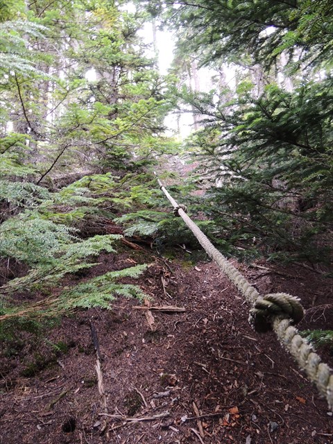
No matter which way you approach, leave the main PNT trail (at this point it is an overgrown logging road) at ( N 48° 38.326 W 122° 15.467 ) and go NE on an overgrown road spur. After following this spur for less than 500 feet, you will see a clearing coming up. Just before entering this clearing ( N 48° 38.390 W 122° 15.399 ) leave the road and head to your left (NW) into the forest. Here you should find a lightly used bootpath that leads you to the bottom of a rope.This rope is very helpful for climbing the steep hillside between the clearing and the summit. If you can't locate the trail or the rope, just scramble straight up the hillside to the top, using the thin trees as anchors.
Northern Approach (12 miles RT): This is the shortest (but certainly not the easiest) route to the top. Park off of "S. Bay Dr." and follow the logging road to the base of a clearcut. Next bushwhack a quarter mile up through the clearcut to a logging road above. This logging road connects with the western approach PNT about two miles from the summit. This route is described in greater detail at the "Lake Whatcom Vista" cache.
Eastern Approach (14 miles RT): Like the western approach, this route follows the PNT. It starts directly off of Hwy 9, and follows a mix of logging roads and originally built trail. Navigation is also easy, as it is very well marked by white paint stripes. The PNT website has a great map of the mountain, which is also available in sections for easy printing. It can be found here. A more detailed description of this route can be found here. The last section of the route is the same for any route and is described above.
The Summit & Cache
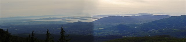
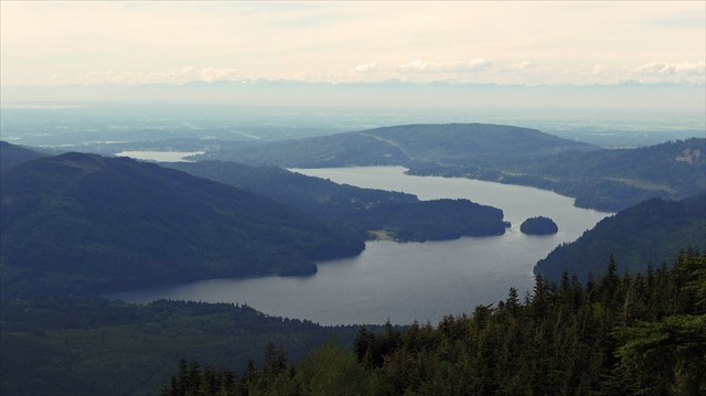
The summit area is sparsely timbered, and it is ringed by steep cliffs to the south, west, and north.The cache is a lock-and-lock box placed next to a mossy open area which provides an excellent view of western Skagit County, the San Juan Islands, and the Olympic Mountains. A clear view of Lake Whatcom can be obtained by carefully following the top of the cliffs north until finding a break in the trees.
The eastern view of Baker and the Twin Sisters range is almost completely obscured by trees. However, an unobstructed view can be gained at the "Eastern Anderson Vista". It is a highly recommended side trip!
I will update this page if trail conditions change. Depending on the amount of snow, this cache is accessible in winter.
Happy Hunting!