It is difficult to tell if a single short ridge of sand and gravel is an esker or a crevasse filling. Most eskers are undulating and gently curving. The ridges at this location are probably crevasse fillings because there are several straight, parallel ridges.
A crevasse is a fissure in the ice formed during the active phase of a surge cycle. As ice deep within a glacier flows, the brittle ice at the top cracks to form the crevasse. Meltwater on a retreating glacier will deposits sand and till to fill the fissure as the stagnant glacier sinks into its bed. When the ice completely melts, it will leave several parallel ridges that are closely spaced, often about one-quarter mile in length.
Crevasses actually form under several different conditions.

Transverse Crevasses form when a glacier travels over a convex surface and the ice bends. The ice on the top gets pulled apart and crevasses tend to form across the glacier perpendicular to the flow.
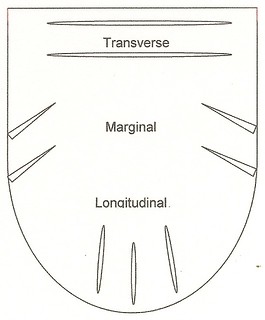
Longitudinal Crevasses form parallel to the flow of the glacier, usually near the terminus as the ice spreads out laterally. The ice becomes shallower near the edges which makes it more sensitive to the underlying terrain.
Marginal Crevasses form along the edge of the glacier which is restrained by the stationary rock along the sides and beneath the thinner ice. Flow rate differences causes tension along 45° angles facing into the glacier.
 IATCC is the cache designation to highlight a series of EarthCaches along the Ice Age National Scenic Trail grouped into a special category called "ColdCache."
The Ice Age Trail is one of eleven National Scenic Trails designated by the National Park Service. This unique trail is entirely within the state of Wisconsin and follows along the terminal moraine of the most recent glacier which retreated about 10,000 years ago.
This project is supported by the Ice Age Trail Alliance (IATA). The goal is to bring more visitors to the trail and promote public awareness, appreciation, and understanding of Wisconsin’s glacial landscape.
The IATA has created an awards program to encourage visits to the trail and ColdCache sites. This awards program is separate from, and in addition to, any other Geo- or EarthCache awards program.
A current list of approved ColdCache sites can be found on the “IATCC Bookmark List”. More information on the Ice Age Trail Atlas, the Companion Guide, the ColdCache Project and Awards Program can be found on the “ColdCache Webpage”
The Geocache Notification Form has been submitted to Jason Quast of the Wisconsin DNR. Geocaches placed on Wisconsin Department of Natural Resource managed lands require permission by means of a notification form. Please print out a paper copy of the notification form, fill in all required information, then submit it to the land manager. The DNR Notification form and land manager information can be obtained at: www.wi-geocaching.com/hiding
Resources
Crevasse-Fill Ridges – A Landform Type Characteristic of Surging Glaciers; by Martin Sharp
Geology of the Ice Age National Scenic Trail; by David M. Mickelson, Louis J. Mahler Jr., and Susan L. Simpson
SummitPost.org
Logging Requirements
- What is the directional orientation of the ridge at each location?
- ______° to ______°
- ______° to ______°
- Based on the directional orientation and the location of the trail on the Lake Michigan lobe side; what type of crevasse would these be?