Ngong Hills
The cache is hidden at Lamwia Peak, the highest and 5th of the 7 Ngong Hills (counting from the northern/Ngong end). There is a short mini-trail heading east from the grassy summit, which is commonly used for 'short calls'. As you enter this trail, you'll see a small depression (or shallow pit) on your left with several stones. The home-made bottle-top cache is under one of these stones. After signing the logbook, please take care to close the zip-lock bag and cache well, and to conceal it carefully with the stones.
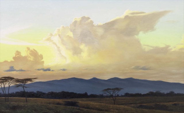
The Ngong Hills (2,460m) are a series of hills on a ridge along the Great Rift Valley, some 23km southwest of Nairobi. 'Ngong' (Maasai) means 'knuckles' describing the appearance of the most prominent 4 hills from the east.
The hills are a popular day-trip destination for visitors including school groups, hikers, picnickers, professional & amateur runners, and worshippers and can become quite busy at weekends!
The hills provide an impressive extended viewpoint. 15km to the east is the Nairobi National Park, to the NE is Nairobi, and to the west the hills overlook Maasai manyattas 1,000m down in the Rift Valley. The whole mountain range is a gazetted 21,000 sq km forest reserve.
Just to the NE of the hills is the busy town/trading centre of Ngong (2009 pop. 107,000), and the suburban residence of many Nairobians. During the years of British  colonial rule, the Ngong Hills area was a major settler farming region, and many traditional half-timbered colonial houses with their large flower gardens can still seen on the lower eastern slopes where the solitary grave of Denys Finch Hatton, marked by an obelisk and garden, is also located, overlooking the national park in the distance.
In the Oscar-winning 1985 film Out of Africa starring Meryl Streep and based loosely on the 1937 autobiographical book of the same name written by Isak Dinesen (the pseudonym of Danish author Karen Blixen), the four most prominent peaks ('knuckles') of the Hills appear in the background of several scenes filmed near Karen Blixen's house. Local residents reported seeing lions in the Hills during the 1990s.
Hiking Trail
This runs all the way along the ridge/peaks of the Ngong Hills as far as Magadi Road near Kona Baridi. It is accessed via a Kenya Forestry Service (KFS) post @ S 01 22.456 E 36 38.520 at the NE foot of the Ngong Hills Forest Recreation Area. (See gallery photo for entry fees as of February 2014). The full trail from the KFS post to Kona Baridi @ S 01 27.817 E 36 39.157 is about 11.5km and takes about 5-6 hours (without long rest breaks) and would of course require a second vehicle to return to Nairobi (unless using public transport).
Otherwise most hikers reach the highest point (the 7th peak called Lamwia - and the location of this cache) and return by the same route making a 12km round trip of 4-5 hours allowing for rest breaks. Some hikers have reported being robbed or mugged on the southern part of the hills in the past - but there have been no recent incidents reported. Kenya Forestry Service provides armed guides/security to accompany you on your hike for a fee of Kshs 1,500/guide. There are numerous buffalo in the bushy/forested part of the hills beyond the 4th hill, so the armed guard is a potentially useful resource! However, resist being be pressured into hiring two guards unless your group is large (say >10 persons).
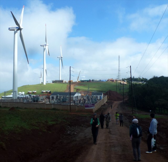 The first part of the trail passes through the Ngong Power Station wind farm operated by KenGen which is located on the lower north-eastern slopes of the hills starting just inside the entrance post. It began in 1993 with 2 turbines donated by the Belgian Government which were later retired. The second phase of 6 turbines was commissioned in August 2009 with a capacity of 5.1 MW contributing however only 0.3% of Kenya's total installed capacity. Now under Ngong II Project, a further 16 x 850kw turbines are being installed to provide another 13.6MW. This is expected to be completed by June 2014.
Beyond the wind farm the next hill top is festooned with various radio and communication towers and masts belonging to Kenya Broadcasting Corporation, various security agencies and others. On the top of the 3rd hill an aircraft navigation beacon to guide the final approach into Jomo Kenyatta International Airport.
To Reach the Cache:
Take the Ngong Road out of Nairobi to the end - a T-junction in the centre of Ngong town. Turn right and after 135m fork left and follow this road around a long left-hand corner as far as the junction just after the Police station @ S 01 21.992 E 36 39.243. Turn right here (signposted 'Ngong Wind Farm') and proceed up this dirt road which gradually ascends 1.8km through settlements to the KFS Gate and entrance where you can park.
If using public transport, take matatu #111 from the terminus near Nairobi Railway Station as far as Ngong town, then hire a bodaboda (motorbike taxi) to take you up to the start of the trail at the KFS post. If you hike all the way to Magadi Rd, you can pick up another matatu there heading back into Nairobi.
After paying your entry and armed guard fees, simply follow the road, then track, then hiking trail over the 6 intervening hills to the high-point where the cache is hidden.
As usual, please retrieve and replace the cache carefully and ensure it is properly hidden and do look out for muggles!
See here for a blog of the hike with some good photos
See here for a blog with excerpts from Karen Blixen's book and interesting archive photos